History of Beaufort, South Carolina

Last updated

The history of Beaufort, South Carolina , is one of the most comprehensive and diverse of any community of its size in the United States.[ citation needed ]

Contents

Overview

The area had been subject to numerous European explorations and several aborted attempts at colonization. Scottish immigrants founded the short-lived "Stuart Town" in 1684, [1] and the British successfully founded the city of Beaufort in 1711, the second-oldest in South Carolina (behind Charleston). The city initially grew slowly, subject to numerous attacks from Native Americans before flourishing as a regional center for the Lowcountry plantation economy up through the Civil War. The community rebounded in the later half of the 20th century and is today recognized as one of the most livable small towns in the country. Beaufort has retained much of its historic character through its renowned architecture and historic preservation efforts.

Colonial period: 1711–1783

The John A. Cuthbert House is an example of antebellum architecture in Beaufort John Cuthbert House (Beaufort, South Carolina).jpg
The John A. Cuthbert House is an example of antebellum architecture in Beaufort

Written history began 500 years ago with the exploration of the area by Spanish Captain Pedro de Salazar between 1514 and 1516. [2] Thus, Beaufort County was the site of the second landing on the North American continent by Europeans;[ citation needed ] the first landing—Ponce de Leon at or near modern St. Augustine, Florida—was only a year or so earlier in 1513.

Beaufort was chartered in 1711 as the second major settlement in South Carolina and named after Henry Somerset, 2nd Duke of Beaufort. The settlement grew very slowly, due to a major attack by the Yemassee in 1717 and the threat of Spanish invasion. It was not until 1733 and the founding of Georgia as a buffer colony did Beaufort truly grow in population and prestige. Though most administrative powers during the early Carolina colony was focused in Charleston, the city gained a reputation for its excellent harbor and the establishment of several church congregations, most notable being St. Helena's Episcopal. By 1776, the city became well known for its shipbuilding enterprises, its rice and indigo trade, and was home to a new circuit court for the colony.

The American Revolution split loyalties in the community, with several families supporting the Tories while others favored independence. Many men fought in battles elsewhere in the state, though little warfare was conducted in and around Beaufort. Following the 1778 capture of nearby Savannah, Georgia, British forces moved to occupy Port Royal Island in late January 1779, but were repulsed by militia under the command of William Moultrie in the Battle of Beaufort. The area was successfully occupied by the British later in 1779, but they withdrew when Savannah came under siege. Most of coastal South Carolina was dominated by British forces after the 1780 Siege of Charleston. After the American victory in the 1781 Siege of Yorktown, the British Army began moving out of the Lowcountry in the summer of 1782. Unlike other regions such as Massachusetts and St. Augustine, Florida, virtually all of the Loyalists in Beaufort decided to stay. South Carolina's leading patriots including the "Swamp Fox" Francis Marion and the "Game Cock" Thomas Sumter were all instrumental in convincing South Carolina's Loyalist community not to leave, and in ensuring that their property and they themselves would be respected in the new country. This effort was successful, and in Beaufort virtually no Loyalists ended up leaving after the war. [3] The Treaty of Beaufort fixing the boundary between South Carolina and Georgia was signed in the city in 1787.

Antebellum period: 1783–1861

In the mid to late antebellum period, the rise of Carolina Gold rice and Sea Island Cotton brought enormous wealth to Beaufort and the surrounding plantations. Beaufort was one of the wealthiest cities in the United States prior to the Civil War and was often considered to be the "Newport" of the South. Although Charleston and Columbia were the leading cities in the state, much economic and political influence was reared by Beaufort. Lowcountry planters in the city and the surrounding islands were among the most ardent supporters of state secession, first during the Nullification Crisis in the 1830s and then in the 1850s. At the eve of secession, Beaufort was arguably at its cultural, economic, and political zenith, with a population of about 4,000, excluding slaves. Like modern-day Beaufort, the city attracted many residents from beyond the state, with many Northerners and Europeans residing in town and operating successful businesses.

Native Beaufortonian Robert Smalls Robert Smalls - Brady-Handy.jpg
Native Beaufortonian Robert Smalls

Civil War and Reconstruction: 1861–1893

The Civil War had a dramatic effect on Beaufort, as an amphibious attack and subsequent occupation of the city in November 1861 made it one of the first communities in the Deep South to be held in Union hands. Though much of the town was spared from physical destruction, there were many incidents of arson and looting. In a historic effort that pre-dated American Reconstruction, the Port Royal Experiment provided a test case for the education of freedmen. In addition to educational advancements, the city made some political ones as well. Robert Smalls, a native son and leading figure in post-war Beaufort would later become one of South Carolina's first elected African-Americans to the United States Congress and remained a prominent civic leader in the state and in Beaufort until his death in 1915. Due in part to the large African-American population and also Small's leading role, Beaufort remained one of the last outposts of Republican Party power in the Solid South.

Some of Beaufort's most prominent families returned to the area but never regained the enormous wealth that slave-based agriculture provided. Most of the original antebellum power brokers never returned to the area. As the influence of cotton declined, the lure of aqua phosphate mining increased. By 1890, Beaufort had regained some of its wealth and prosperity from that industry. It had also retained its position as county seat during that time, having previously lost it to railroad community of Coosawhatchie. However, a series of events would bring Beaufort into a steady economic decline for over half-century.

Decline: 1893–1945

The 1893 Sea Islands Hurricane caused extensive structural damage 1893 sea islands hurricane damaged houses.jpg
The 1893 Sea Islands Hurricane caused extensive structural damage

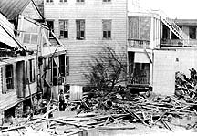
On August 27, 1893, a Category 3 hurricane slammed into the Lowcountry, killing over 2,000 area residents and causing immeasurable damage. Although only four individuals died in the city itself, Beaufort was heavily damaged and its phosphate industry was ruined. A fire that damaged much of the downtown area in 1907 continued to inflict economic and psychological harm to the city. A final blow to the area was gradual; the boll weevil decimated most of the cotton crop, which had for over a century been the major commodity of the community. By 1910, Beaufort had lost almost 40% of its population from ten years earlier. Though the city retained its political status as county seat, Beaufort became one of the poorest communities in the state through the 1940s. The growth of lettuce and tomato farming, in addition to shrimping, became the major facets of the economy during this time.

Recovery: 1945 – present

Beaufort's economic recovery in the latter half of the 20th century can be contributed to three major influences: military investment, resort development, and downtown revitalization. Although Parris Island was continuously occupied after the Civil War, it retained a limited role in military affairs until 1917, when it was selected as a permanent home for the U.S. Marine Corps recruiting station. The onslaught of World War I, World War II and especially the Cold War brought new people and income to the area. A naval air station was established during World War II and transferred to the Marine Corps in the 1950s, thus cementing a major military legacy for the region. A U.S. Naval Hospital located in neighboring Port Royal was also constructed during the war.

New investment in the form of resort and lifestyle development on nearby Hilton Head Island and Fripp Island also contributed to the economy of Beaufort and the Lowcountry starting in the 1960s. Significant economic improvement came upon the completion of a downtown waterfront park in place of abandoned docks, championed by then-mayor Henry Chambers. The park (now named after Chambers) spurred the redevelopment and reinvestment of adjacent Bay Street and downtown Beaufort, propelling land values and commanding the attention of real estate investors, national media, and Hollywood. [4] In recent years, renovations to the park, countless renovations to private homes and businesses, and several streetscape projects have continued to improve the overall quality of life in Beaufort.

Unlike most communities of its size in the south, Beaufort escaped much of the turbulence of the Civil Rights Movement. Jim Crow laws were gradually eased during the 1960s. Schools began the process of desegregation in 1964 and became fully integrated by 1970. Beaufort also elected its first African-American to city council (since 1910) in 1967. The city has experienced other demographic shifts, thanks in part to the city's military presence, its status as a retirement destination for residents from the northern United States and Canada, and a demand for migrant workers, primarily from Latin American nations and mostly for seasonal agriculture.

See also

Notes

    Related Research Articles

    <span class="mw-page-title-main">South Carolina</span> U.S. state

    South Carolina is a state in the coastal Southeastern region of the United States. It is bordered to the north by North Carolina, to the southeast by the Atlantic Ocean, and to the southwest by Georgia across the Savannah River. South Carolina is the 40th most extensive and 23rd most populous U.S. state with a recorded population of 5,124,712 according to the 2020 census. In 2019, its GDP was $213.45 billion. South Carolina is composed of 46 counties. The capital is Columbia with a population of 137,300 in 2020; while its largest city is Charleston with a 2020 population of 150,277. The Greenville–Spartanburg-Anderson metropolitan area is the most populous in the state, with a 2020 population estimate of 1,455,892.

    <span class="mw-page-title-main">Charleston, South Carolina</span> Largest city in the U.S. state of South Carolina

    Charleston is the largest city in the U.S. state of South Carolina, the county seat of Charleston County, and the principal city in the Charleston–North Charleston metropolitan area. The city lies just south of the geographical midpoint of South Carolina's coastline on Charleston Harbor, an inlet of the Atlantic Ocean formed by the confluence of the Ashley, Cooper, and Wando rivers. Charleston had a population of 150,277 at the 2020 census. The 2020 population of the Charleston metropolitan area, comprising Berkeley, Charleston, and Dorchester counties, was 799,636 residents, the third-largest in the state and the 74th-largest metropolitan statistical area in the United States.

    <span class="mw-page-title-main">Beaufort, South Carolina</span> City in South Carolina, United States

    Beaufort is a city in and the county seat of Beaufort County, South Carolina, United States. Chartered in 1711, it is the second-oldest city in South Carolina, behind Charleston. The city's population was 12,361 in the 2010 census. It is a primary city within the Hilton Head Island-Bluffton-Beaufort, SC Metropolitan Statistical Area.

    <span class="mw-page-title-main">Bluffton, South Carolina</span> Town in South Carolina, United States

    Bluffton is a town in Beaufort County, South Carolina, United States. It is primarily located around U.S. Route 278, between Hilton Head Island and Interstate 95. The Lowcountry town's original one square mile area, now known as Old Town, is situated on a bluff along the May River. The population as of the 2020 census was 27,716, an increase of over 120% since 2010, making it one of the fastest growing municipalities in South Carolina with a population over 2,500. Bluffton is the fifth largest municipality in South Carolina by land area. The town is a primary city within the Hilton Head Island-Bluffton-Beaufort, SC Metropolitan Statistical Area.

    <span class="mw-page-title-main">Hardeeville, South Carolina</span> City in South Carolina, United States

    Hardeeville is a city in Jasper and Beaufort counties in the U.S. state of South Carolina. The population was 7,473 as of the 2020 census, an increase of over 150% since 2010. Hardeeville is included within the Hilton Head Island-Bluffton-Beaufort, SC Metropolitan Statistical Area.

    <span class="mw-page-title-main">Saint Helena Island (South Carolina)</span> Island in South Carolina, United States

    St. Helena Island is a Sea Island in Beaufort County, South Carolina, United States. The island is connected to Beaufort by U.S. Highway 21. The island has a land area of about 64 sq mi (170 km2) and a population of 8,763 as of the 2010 census. It is included as part of the Hilton Head Island-Beaufort Micropolitan Area. The island is renowned for its rural Lowcountry character and being a major center of African-American Gullah culture and language. It is considered to be the geographic influence behind the children's television program Gullah Gullah Island.

    <span class="mw-page-title-main">Daufuskie Island</span> Census-designated place in South Carolina, United States

    Daufuskie Island, located between Hilton Head Island and Savannah, is the southernmost inhabited sea island in South Carolina. It is 5 miles (8 km) long by almost 2.5 miles (4.0 km) wide – approximate surface area of 8 square miles (21 km2). With over 3 miles (5 km) of beachfront, Daufuskie is surrounded by the waters of Calibogue Sound, the Intracoastal Waterway and the Atlantic Ocean. It was listed as a census-designated place in the 2020 census with a population of 557.

    <span class="mw-page-title-main">South Carolina Lowcountry</span> Geographic and cultural region located along South Carolinas coast

    The Lowcountry is a geographic and cultural region along South Carolina's coast, including the Sea Islands. The region includes significant salt marshes and other coastal waterways, making it an important source of biodiversity in South Carolina.

    South Carolina was one of the thirteen colonies that first formed the United States. European exploration of the area began in April 1540 with the Hernando de Soto expedition, which unwittingly introduced diseases that decimated the local Native American population. In 1663, the English Crown granted land to eight proprietors of what became the colony. The first settlers came to the Province of Carolina at the port of Charleston in 1670. They were mostly wealthy planters and their slaves coming from the English Caribbean colony of Barbados. They started to develop their commodity crops of sugar and cotton. The Province of Carolina was split into North and South Carolina in 1712. Pushing back the Native Americans in the Yamasee War (1715–17), colonists next overthrew the proprietors' rule in the Revolution of 1719, seeking more direct representation. In 1719, South Carolina became a crown colony.

    <span class="mw-page-title-main">Colonial period of South Carolina</span> History of the colonial period of South Carolina

    The history of the colonial period of South Carolina focuses on the English colonization that created one of the original Thirteen Colonies. Major settlement began after 1651 as the northern half of the British colony of Carolina attracted frontiersmen from Pennsylvania and Virginia, while the southern parts were populated by wealthy English people who set up large plantations dependent on slave labor, for the cultivation of tobacco, cotton, rice, and indigo.

    South Carolina was outraged over British tax policies in the 1760s that violated what they saw as their constitutional right to "no taxation without representation". Merchants joined the boycott against buying British products. When the London government harshly punished Massachusetts for the Boston Tea Party, South Carolina's leaders joined eleven other colonies in forming the Continental Congress. When the British attacked Lexington and Concord in the spring of 1775 and were beaten back by the Massachusetts Patriots, South Carolina Patriots rallied to support the American Revolution. Loyalists and Patriots of the colony were split by nearly 50/50. Many of the South Carolinian battles fought during the American Revolution were with loyalist Carolinians and the part of the Cherokee tribe that allied with the British. This was to General Henry Clinton's advantage. His strategy was to march his troops north from St. Augustine, Florida, and sandwich George Washington in the North. Clinton alienated Loyalists and enraged Patriots by attacking a fleeing army of Patriot soldiers who posed no threat. Enslaved Africans and African Americans chose independence by escaping to British lines where they were promised freedom.

    Antebellum South Carolina is typically defined by historians as South Carolina during the period between the War of 1812, which ended in 1815, and the American Civil War, which began in 1861.

    <span class="mw-page-title-main">Southern theater of the American Revolutionary War</span> Military conflicts in the southeastern United States during the American Revolution

    The Southern theater of the American Revolutionary War was the central theater of military operations in the second half of the American Revolutionary War, 1778–1781. It encompassed engagements primarily in Virginia, Georgia and South Carolina. Tactics consisted of both strategic battles and guerrilla warfare.

    <span class="mw-page-title-main">Area codes 843 and 854</span> Telephone area codes for eastern South Carolina, United States

    Area codes 843 and 854 are telephone area codes in the North American Numbering Plan (NANP) for that portion of the U.S. state of South Carolina comprising roughly the eastern third and the southern tip. The numbering plan area (NPA) includes the Grand Strand, the Lowcountry, the Pee Dee, and the Sandhills. Major cities in the region are Myrtle Beach, Charleston, Beaufort, Hilton Head Island and Florence. Area code 843 was created in 1998 when area code 803 was split, while 854 was added in 2015 to form an all-services overlay.

    John Kizell was an American immigrant to Sierra Leone, who became a leader in Sierra Leone as it was being developed as a new British colony in the early nineteenth century. Believed born on Sherbro Island, he was captured and enslaved as a child, and shipped to Charleston, South Carolina, where he was sold again. Years later, after the American Revolutionary War, during which he gained freedom with the British and was evacuated to Nova Scotia, he eventually returned to West Africa. In 1792 he was among 50 native-born Africans among the 1200 mostly African-American Black Loyalists who were resettled in Freetown.

    <span class="mw-page-title-main">Economy of South Carolina</span> Overview of the economy of South Carolina

    The economy of South Carolina was ranked the 25th largest in the United States based on gross domestic product in 2022. Tourism, centered around Myrtle Beach, Charleston, and Hilton Head Island, is the state's largest industry. The state's other major economic sector is advanced manufacturing located primarily in the Upstate and the Lowcountry.

    <span class="mw-page-title-main">History of Charleston, South Carolina</span> From 1663 to present day

    The history of Charleston, South Carolina, is one of the longest and most diverse of any community in the United States, spanning hundreds of years of physical settlement beginning in 1670. Charleston was one of leading cities in the South from the colonial era to the Civil War in the 1860s. The city grew wealthy through the export of rice and, later, sea island cotton and it was the base for many wealthy merchants and landowners. "Charleston was the capital of American slavery."

    <span class="mw-page-title-main">ACE Basin</span> Ashepoo, Combahee and Edisto Basin

    The Ashepoo, Combahee and Edisto Basin is one of the largest undeveloped estuaries along the Atlantic Coast of the United States. Located primarily in Colleton, Charleston, and Beaufort counties in South Carolina, the Ashepoo, Combahee and South Edisto rivers combine into the larger St. Helena Sound and drain a significant portion of the Lowcountry region. The 350,000 acres (1,400 km2) area is known for its natural environment and the preservation of its marshes, wetlands, hardwood forests, and riverine systems and the fauna that occupy the area.

    Pocotaligo is an unincorporated community located in northeastern Jasper County, South Carolina, United States, close to the border of Beaufort County. The community takes its name from the Pocotaligo River, a small tidal creek that separates Jasper and Beaufort counties. Although historically significant, Pocotaligo today primarily serves as a junction point between U.S. Highway 17, U.S. Highway 17 Alternate and U.S. Highway 21. These roads lead to Interstate 95 at Point South and Yemassee, which have over time eclipsed Pocotaligo in population and importance. Very few people live in the community today.

    <span class="mw-page-title-main">Callawassie Island</span> Island in South Carolina, United States

    Callawassie Island is one of hundreds of barrier and sea islands in the southeast corner in the outer coastal plain, making up a portion of Beaufort County, South Carolina.

    References

    1. Peter N. Moore, Carolina's Lost Colony: Stuarts Town and the Struggle for Survival in Early South Carolina (University of South Carolina, 2022), pp. 1-2.
    2. Hoffman, Paul E. (1980). "A New Voyage of North American Discovery: Pedro de Salazar's Visit to the "Island of Giants"". The Florida Historical Quarterly. 58 (4): 415–426. ISSN   0015-4113. JSTOR   30140493.
    3. South Carolina Loyalists in the American Revolution by Robert Stansbury Lambert, University of South Carolina Press, 1987
    4. "Archived copy". Archived from the original on 2017-09-16. Retrieved 2022-07-09.{{cite web}}: CS1 maint: archived copy as title (link)