History of rail transport in Chile

Last updated

This article is part of the history of rail transport by country series
The Biobio Railroad Bridge under construction.
Credit: The Illustrated London News (24 August 1889). Chile Bio-Bio Bridge 1889.jpg
The Biobío Railroad Bridge under construction.
Credit: The Illustrated London News (24 August 1889).
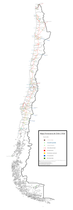
Chile rail map of 1930 Mapa ferroviario Chile 1930.svg
Chile rail map of 1930

The history of rail transport in Chile has gone through several periods of boom and bust. It began in 1840, with the construction by William Wheelwright of the first branch in the north (from Copiapo Caldera; see below). Further construction proceeded apace [1] [2] linking cities from Pisagua all the way to Puerto Montt.

Contents

In addition, there was a network on the big island of Chiloe, and a host of now completely abandoned branches. [3]

Four cross border lines were also built:

The majority of rail infrastructure in Chile was constructed by private enterprise for freight transport, particularly for mining and to some extent forestry. The state did construct and operate some railways, first as FFCC del Estado (in English, 'State Railways'), renamed in 1994 Empresa de los Ferrocarriles del Estado or EFE (in English, 'State Railway Company'). [4] The rail networks in the North and South were essentially separate; in the North used 1,000 mm (3 ft 3+38 in) metre gauge , while the South used 5 ft 6 in (1,676 mm) Indian gauge. [5] [6]

At its peak in 1913, the national rail system had 7,658 km (4,758 mi) of track. It carried about 21 million passengers in 1946 and about 27 million in 1973. [7]

Starting in the 1950s, passenger and freight transport service started to decline due to lack of investment in infrastructure and rolling stock. In 1978, all state funds were cut off to EFE leading to a major crisis. [4] [8] [9] Since the 1990s, with the return of democracy as well as the increase in population density, the need and commitment to create interurban public transport systems at the national level has re-emerged, beginning a financing process for track renovation and the purchase of new rolling stock (such as the Biotrén, Valparaíso Metro or Metrotren Nos), as well as tourist and preservation services. [10] [11] [12] [13] As of 2014, Chile had about 5,500 kilometers (3,400 mi) of operational track, [14] of which 2,200 km (1,400 mi) was managed by the state. [15]

The resurgence of renewable energy in Chile is causing the authorities to consider the possibility of restoring suspended train lines and the creation of new electrified rail projects, public and private. [16]

Northern Network

FCAB railroad crossing the Carcote salar, northern Chile Ferrocarril en el salar de Carcote, Chile, 2016-02-09, DD 70.JPG
FCAB railroad crossing the Carcote salar, northern Chile

La Red Norte (in english, 'Northern Network') ran from the extreme north of Chile, where the Arica–La Paz railway is located, to La Calera in the Valparaíso Province. [5] Its tracks were 1,000 mm (3 ft 3+38 in) metre gauge . However, several sections had originally 1,435 mm (4 ft 8+12 in) standard gauge including the first Chilean railroad from Caldera to Copiapó (see below) and the railroad from Coquimbo to Ovalle. [17]

The North Network ceased to functions on 16 June 1975, after mounting financial losses. [18] This led to the decline of operating branch lines, with some sections of the railway being sold to other companies, some of which maintain cargo services between different locations, such as the Romeral Railway which operates an iron ore line from Romeral mine to the port of Guayacán, and owns the old section of the Northern Longitudinal Railway between La Serena and Coquimbo. [5]

The Trans-Andean Railroad

The Trasandino Los Andes – Mendoza Railway linked the Chilean city of Los Andes with the city of Mendoza in Argentina. Its route began in the Chilean city and went up through the Aconcagua River to Las Cuevas, where there was a tunnel that crossed into Argentina. Then, it continued along the Las Cuevas and Mendoza rivers until reaching the city of the same name.

The Trasandino Railroad was inaugurated on 5 April 1910 and ended its operations in 1984. It was laid to 1,000 mm (3 ft 3+38 in) metre gauge and partially equipped with Abt rack. Much of the infrastructure (bridges and tracks) is still visible. [19]

Arica–La Paz railway

The railway line that connects the cities of Arica and La Paz was built between 1906 and 1913 and was inaugurated on 13 May 1913 . It was entirely administered by Chile until 1928, when Bolivia began to administer the section that runs through its territory. Today the Chilean section is a freight line operated by FCALP. [20]

Antofagasta – La Paz railway

The Ferrocarril de Antofagasta a La Paz was a 1,000 mm (3 ft 3+38 in) metre gauge railway line established at the end of the 19th century as "Antofagasta (Chili) and Bolivia Railway Company".

Until the mid-1970s, the line provided cargo and passenger transport services between the towns of Antofagasta, Ollagüe and La Paz. Currently, the company "Ferrocarril de Antofagasta a Bolivia" (FCAB) uses the railways to transport cargo [21] to and from Bolivia, and also connects its line with the Andean Railway of Bolivia, Ferronor in Chile, and Ferrocarril Belgrano in Argentina.

Mineral lines

There were also private industrial lines such as the Anglo-Chilean Nitrate & Railway Company's Tocopilla nitrate railway [22] which hauled nitrate for decades until 2015 when flood damage put it beyond economic repair.

The first railway: from Caldera to Copiapó

Copiapo Station, now a historical monument in the Atacama region Estacion de ferrocarriles de copiapo.jpg
Copiapo Station, now a historical monument in the Atacama region

The 25 December 1851 was unforgettable for Copiapó. To the rhythm of bells and whistles the first train that made the full journey from Caldera made its entrance to the so called silver capital of Chile, hauled by a locomotive named after the city. It was a triumph for businessman William Wheelwright, an American living in Chile, who after successfully promoting the foundation of the Pacific Steam Navigation Company, embarked on the enterprise of developing the first railway in Chile. He managed to interest several wealthy businessmen, obtaining an initial capital of 800,000 pesos at the time. On 20 November 1849 the government of Manuel Bulnes gave him a firm concession for the nascent Compañía del Camino Ferro-Carril de Copiapó. The reason for building the railway was the discovery in 1832 by Juan Godoy, a humble woodcutter, an enormous silver deposit in Chañarcillo. The need to transport the ore from the interior to the coast, combined with the availability of capital, led to this first Chilean railway.

The works began in March 1850 under the aegis of North American engineers Walton Evans and the Campbell brothers, Alejandro and Allan. 1,435 mm (4 ft 8+12 in) standard gauge was chosen and the layout of the port to the interior was the same as it is today, although the original track was relaid to 1,000 mm (3 ft 3+38 in) metre gauge (for compatibility with the Northern Network) at the beginning of the 20th century. The locomotives and complementary rolling stock were entrusted to the Norris Locomotive Works in the United States, which built many of the powerful machines that opened the path to the West. The equipment arrived on 21 June 1851 in Caldera at 30 km/h.

Thomson says that Wheelwright tried to open the first section on 4 July to coincide with US Independence day but it was not possible. The first test took place on 29 July and was the first time a train ran in Chile, and the third in South America. [FC-LA 1]

From 1 January the train made a daily journey. It left Copiapó at 9 am and arrived at 1 pm in Caldera. At 3 pm it began its return from the port to arrive in the city at 6.30. For those who traveled in first class the ticket cost 4 pesos and 2 reales. For those who traveled in second class, the ticket cost 2 pesos and 1 real. The cargo rate was 4 reals per quintal. Twice a week, a mail train ran in whose last car ran a gambling bank called "la timba", which lightened the pockets of the hard-working miners who were fond of gambling.

The track was later extended to the nearby towns of Puquios and San Antonio and a station was built in Copiapó. They also acquired the route to Chañarcillo, completing 142 kilometers of track. Wheelwright dreamed of a transcontinental railroad but, although he obtained concessions in Argentina, he fell 400 kilometers short of the total of 1,375 needed to complete his dream.

For 58 years the railroad was privately operated, but the decline of mining and the high rates charged led to a campaign to have it purchased by the state, which happened in 1910.

Southern Network

La Calera Station platforms Estacion Calera (10272356064).jpg
La Calera Station platforms

The main line from Valparaíso to Puerto Montt and all its associated branches and sub-branches is known as the Red Sur de Ferrocarriles del Estado (in English, the Southern network of the state railways.

Some of its most important points are (or were), La Calera, where it connected with the North Network, Alameda Station (better known as Central Station) in Santiago and the stations located in large cities from Santiago to Puerto Montt (Talca, Chillán, Temuco, etc).

Practically the entire South Network was built by the State of Chile, initially to unite the few existing cities south of Santiago and later to integrate and establish sovereignty over the Araucanía territories that were being colonized.

Given that the longitudinal track runs, in general terms, in a north-south direction through the central valley of the country, a large number of branches connect(ed) to it reachingi the cities located to the east and west of the main line. For operational, political-social and even financial reasons, many of the old branches were abandoned and dismantled after competition from road transport became more important. They can provide freight services such as Santiago – San Antonio, San Pedro – Ventanas, Llay – Llay – Los Andes – Saladillo; or passengers services between close large cities such as Corto del Laja (Talcahuano – Laja) or the Biotrén (which connects the communes of Talcahuano, San Pedro de la Paz, Coronel, Chiguayante and Hualqui with Concepción).

An exceptional case is the 1,000 mm (3 ft 3+38 in) metre gauge Talca-Constitución line. A railbus to provides a subsidized service to a series of towns located on the bank of the Maule River that do not have road access. After temporary interruption as a result of the devastation caused by the earthquake of 27 February 2010, the service was restored, currently operating normally between Talca and Constitución.

As of 2020, practically the entire trunk network is used to transport cargo, although only a small section from Valparaíso to Limache and from Santiago Alameda Station to Chillán continue to provide passenger services.

Santiago–Valparaíso railway

Estacion Central, km 0 for the national network J24 707 Estacion central, Fernbahngleise.jpg
Estación Central, km 0 for the national network

The existing rail line between Santiago and Valparaíso was opened in 1863, and is 187 km (116 mi) long, single-track and designed to avoid steep gradients through mountainous terrain. Passenger service ceased on this line in 1987, and freight traffic almost non-existent since then. [23] Proposals have existed since the 1990s to build a more direct line between the two cities for passengers and freight. The section from Valparaíso to Limache was doubled and put underground in Viña del Mar as part of the Valparaíso Metro.

Chiloé railway

The Chiloé railway was a 600 mm (1 ft 11+58 in) gauge railway on Chiloé Island, running between Ancud and Castro, with a spur to the Lechagua port. It operated between 1912 and 1960.

Structures

Other lines

Railway map of Chile in 2023 Mapa ferroviario Chile 2023.svg
Railway map of Chile in 2023

In addition to all these longitudinal lines, the Chilean railway network had endless branches of a local nature, with almost all of Chile connected from Iquique to Puerto Montt. Some of the branches were:

Notes

  1. (The first was in Georgetown-Plaisance (8 km) in British Guiana, opened in November 1848. The second was the Callao-Limaline (14 km), which began operations in April 1851.

See also

Related Research Articles

<span class="mw-page-title-main">Transport in Chile</span>

Transport in Chile is mostly by road. The far south of the country is not directly connected to central Chile by road without travelling through Argentina, and water transport also plays a part there. The railways were historically important in Chile, but now play a relatively small part in the country's transport system. Because of the country's geography and long distances between major cities, aviation is also important.
<span class="mw-page-title-main">Mountain railway</span> Railway which operates within a mountainous region

A mountain railway is a railway that operates in a mountainous region. It may operate through the mountains by following mountain valleys and tunneling beneath mountain passes, or it may climb a mountain to provide transport to and from the summit.

<span class="mw-page-title-main">Trans-Andean railways</span>

The Trans-Andean railways provide rail transport over the Andes. Several are either planned, built, defunct, or waiting to be restored. They are listed here in order from north to south.

<span class="mw-page-title-main">Empresa de los Ferrocarriles del Estado</span> State-owned railway company in Chile

Empresa de los Ferrocarriles del Estado is the national railway and the oldest state-run enterprise in Chile. It manages the infrastructure and operating rail services in the country.

<span class="mw-page-title-main">Rail transport in Peru</span>

Rail transport in Peru has a varied history. Peruvian rail transport has never formed a true network, primarily comprising separate lines running inland from the coast and built according to freight need rather than passenger need.

<span class="mw-page-title-main">Transandine Railway</span> Railway between Argentina and Chile (1910–84)

The Transandine Railway was a 1,000 mmmetre gauge combined rack and adhesion railway which operated from Mendoza in Argentina, across the Andes mountain range via the Uspallata Pass, to Santa Rosa de Los Andes in Chile, a distance of 248 km.

<span class="mw-page-title-main">Ferrocarril de Antofagasta a Bolivia</span> Narrow gauge railway line in Chile

The Ferrocarril de Antofagasta a Bolivia is a private railway operating in the northern provinces of Chile. It is notable in that it was one of the earliest railways built to 2 ft 6 in narrow gauge, with a route that climbed from sea level to over 4,500 m (14,764 ft), while handling goods traffic totaling near 2 million tons per annum. It proved that a railway with such a narrow gauge could do the work of a standard gauge railway, and influenced the construction of other railways such as the Estrada de Ferro Oeste de Minas. It was later converted to 1,000 mmmetre gauge, and still operates today.

<span class="mw-page-title-main">Roman Catholic Archdiocese of Santiago de Chile</span> Latin Catholic archdiocese in Chile

The Metropolitan Archdiocese of Santiago de Chile is one of the five Latin metropolitan sees of the Catholic Church in Chile.

<span class="mw-page-title-main">Ferrocarriles Patagónicos</span> Former Argentine State-owned railway company (1908–1948)

Ferrocarriles Patagónicos was an Argentine State-owned railway company that built and operated several rail lines in Patagonia region. FP were part of the Argentine State Railway created in 1909 during the presidency of José Figueroa Alcorta.
<span class="mw-page-title-main">Rail transport in Bolivia</span>

The Bolivian rail network has had a peculiar development throughout its history.

<span class="mw-page-title-main">Arica–La Paz railway</span> International railway line between Chile and Bolivia

The Arica–La Paz railway or Ferrocarril de Arica–La Paz (FCALP) was built by the Chilean government under the Treaty of Peace and Friendship of 1904 between Chile and Bolivia. The railway line was inaugurated on 13 May 1913 and is the shortest line from the Pacific Coast to Bolivia. It is 440 km (273 mi) long, of which 233 km (145 mi) is in Bolivian territory. The Railway is meter gauged. Until 1968, it was rack worked over a 43 km section, on the Chilean side, between Central and Puquios. The line reaches a height of 4257 meters above sea level at General Lagos. The Chile - Bolivia border is crossed between the stations of Visviri and Charaña. When the railway is in operation, it is used for the export of Bolivian minerals and some agricultural production as well as the import of merchandise into Bolivia.

This is an order of battle of the Chilean Army.

The most common track gauge in Chile is the Indian gauge 1,676 mm. In the north there is also some 1,000 mm, metre gauge, rail track.

<span class="mw-page-title-main">Salta–Antofagasta railway</span> Railway line in Argentina and Chile

The Salta–Antofagasta railway, also named Huaytiquina, is a non-electrified single track railway line that links Argentina and Chile passing through the Andes. It is a 1,000 mmmetre gauge railway with a total length of 941 km, connecting the city of Salta (Argentina) to the one of Antofagasta (Chile), on the Pacific Ocean, passing through the Puna de Atacama and Atacama Desert.

<span class="mw-page-title-main">Narrow-gauge railways in Spain</span>

In Spain there is an extensive 1,250 km (780 mi) system of 1,000 mmmetre gauge railways. The majority of these railways was historically operated by FEVE,. Created in 1965 FEVE started absorbing numerous private-owned narrow-gauge railways. From 1978 onwards, with the introduction of regionalisation devolution under the new Spanish constitution, FEVE began transferring responsibility for a number of its operations to the new regional governments. On 31 December 2012 the company disappeared due to the merger of the narrow-gauge network FEVE and the broad-gauge network Renfe.

<span class="mw-page-title-main">History of rail transport in Bolivia</span>

The history of rail transport in Bolivia began in the 1870s after almost three decades of failed efforts to build railroads to integrate the country, mining was the driving force for the construction of railways. The need to transport saltpeter to the coast triggered the first railway lines in Bolivia. It was the silver mining, however, that drove the construction of a railway from the Pacific coast to the high plateau during the nineteenth century. Later, at the beginning of the twentieth century, tin mining gave a new impetus to railway building, forming what is now known as the Andean or Western network. The eastern network, on the other hand, developed between the years 1940 and 1960 and is financed in exchange for oil through agreements with Argentina and Brazil. Bolivia being a landlocked country, the railways played a fundamental role and the history of its railroads is the history of the country's efforts to reach first ports on the Pacific coast and then the Atlantic.

<span class="mw-page-title-main">Tocopilla nitrate railway</span>

The María-Elena - Tocopilla line was the last operating nitrate railway in Chile, and the last operating section of a railway system that moved caliche ore to processing plants and nitrate to the port of Tocopilla. It was a magnet for rail fans before closing in August 2015 after severe rainfall damaged the tracks to the extent that the owner decided it was beyond economic repair.
<span class="mw-page-title-main">Agua Santa nitrate railway</span> Railway line in Chile

The Ferrocarril de Agua Santa was a railway line in the old province of Tarapacá in Chile between 1890 and 1931.

References

  1. Edwards, María Piedad Alliende (16 December 2017). "The Construction of the Railways in Chile 1850–1913". Austral Journal of Social Sciences (5): 143–161. doi: 10.4206/rev.austral.cienc.soc.2001.n5-13 . ISSN   0718-1795 . Retrieved 8 June 2018.
  2. Bengoa, José (24 January 2018). The lost community: Identity and culture: challenges of modernization in Chile (in Spanish). Editorial Catalonia. ISBN   9789563245868 . Retrieved 8 June 2018.
  3. Mateo, Martinic B. (2005). "Ferrocarriles en la Zona Austral de Chile, 1869–1973". Historia. 38 (2): 367–395. doi: 10.4067/S0717-71942005000200005 . ISSN   0717-7194 . Retrieved 8 June 2018.
  4. 1 2 Ortega, Andrea (29 July 2013). "Rieles que unen. Patrimonio ferroviario y configuración del paisaje cultural urbano del Ferrocarril al Sur entre Estación Central y San Bernardo (1905–2013)" (in Spanish). Archived from the original on 12 June 2018. Retrieved 2 June 2018.{{cite journal}}: Cite journal requires |journal= (help)
  5. 1 2 3 "Empresa de Transporte Ferroviario SA (FERRONOR)". www.ferronor.cl. Retrieved 8 June 2018.
  6. Global Logistics Assessments Reports Handbook : Strategic Transportation and Customs Information for Selected Countries. Int'l Business Publications. 15 February 2008. ISBN   9780739766033.
  7. León Donoso, Víctor Manuel (2017). "La decadencia del ferrocarril en la red centro sur de Chile (1950–1990)" (PDF). XVI JORNADAS INTERESCUELAS MAR DEL PLATA. Retrieved 8 June 2018.
  8. Vedoya, Sebastián (9 July 2017). "President EFE: "No vamos a sacar mucho con más Metro y ferrocarriles sino limitamos la congestión vehicular"". Publimetro Chile (in Spanish). Retrieved 8 June 2018.
  9. Polanco Silva, Ana Karen (2015). "TRABAJADORES FERROVIARIOS DE LA COMUNA DE VALDIVIA Y LA CONSTRUCCIÓN DE SU IDENTIDAD EN TORNO A LA EMPRESA DE FERROCARRILES DEL ESTADO (EFE), 1973–1993" (PDF). Retrieved 8 June 2018.{{cite journal}}: Cite journal requires |journal= (help)
  10. Moraga, Efraín (26 January 2018). "Los proyectos que revitalizarían el transporte y la cultura ferroviaria". PULSO (in Spanish). Archived from the original on 12 June 2018. Retrieved 8 June 2018.
  11. "Proponen tren rápido hacia el sur del país para descongestionar la Ruta 5". CNN Chile. 6 April 2018. Retrieved 8 June 2018.
  12. "Ferrocarriles – Infraestructura para Chile". Infraestrura para Chile (in Spanish). Retrieved 8 June 2018.
  13. "Grupo EFE". www.efe.cl. Archived from the original on 12 June 2018. Retrieved 8 June 2018.
  14. "Rail lines (total route-km) – Chile". World bank. Retrieved 22 November 2020.
  15. "Una Nueva Etapa – Plan Maestro 2014–2020" (PDF). Archived from the original (PDF) on 12 June 2018. Retrieved 22 November 2020.
  16. Hair, Carla. "Los proyectos por US$4.200 millones que buscan revivir el tren en Chile". Pulse. Latercera.com. Retrieved 12 May 2019.
  17. In a letter, Alexander Agassiz writes "The railroad from Coquimbo to Ovalle... is a remarkable piece of engineering....the whole thing is spoiled by the absurdly broad gauge ....as broad as that of the Erie Railroad". In p. 133 of Agassiz, G.R. (1913) Letters and recollections of Alexander Agassiz. Constable & Co., 454 p.
  18. "El fin del mítico "Longino"". La Estrella de Antofagasta. 21 March 2016. Retrieved 26 March 2016.
  19. Roberto D. Bloch (2002), Los tres ferrocarriles trasandinos
  20. "Ministros de Relaciones Exteriores y Transportes verifican en terreno operación del ferrocarril Arica – La Paz". Ferrocarril Arica-La Paz. 25 August 2015. Archived from the original on 6 May 2017. Retrieved 11 April 2018.
  21. Daniel Thomas. "A diamond in the desert". LatinTracks. Retrieved 21 April 2020.
  22. See Binns, Donald. The Anglo-Chilean Nitrate & Railway Company. (1995, Trackside Publications). ( ISBN   1-900095025).
  23. "Third proposal unveiled for Chilean high-speed line". International Rail Journal. 8 May 2019. Retrieved 29 July 2019.

Further reading

Commons-logo.svg Media related to History of rail transport in Chile at Wikimedia Commons