The Colorado River is one of the principal rivers in the Southwestern United States and in northern Mexico. The 1,450-mile-long (2,330 km) river, the 5th longest in the United States, drains an expansive, arid watershed that encompasses parts of seven U.S. states and two Mexican states. The name Colorado derives from the Spanish language for "colored reddish" due to its heavy silt load. Starting in the central Rocky Mountains of Colorado, it flows generally southwest across the Colorado Plateau and through the Grand Canyon before reaching Lake Mead on the Arizona–Nevada border, where it turns south toward the international border. After entering Mexico, the Colorado approaches the mostly dry Colorado River Delta at the tip of the Gulf of California between Baja California and Sonora.

Glen Canyon Dam is a concrete arch-gravity dam in the southwestern United States, located on the Colorado River in northern Arizona, near the city of Page. The 710-foot-high (220 m) dam was built by the Bureau of Reclamation (USBR) from 1956 to 1966 and forms Lake Powell, one of the largest man-made reservoirs in the U.S. with a capacity of more than 25 million acre-feet (31 km3). The dam is named for Glen Canyon, a series of deep sandstone gorges now flooded by the reservoir; Lake Powell is named for John Wesley Powell, who in 1869 led the first expedition to traverse the Colorado River's Grand Canyon by boat.
Lake Powell is a reservoir on the Colorado River in Utah and Arizona, United States. It is a major vacation destination visited by approximately two million people every year. It holds 24,322,000 acre-feet (3.0001×10¹⁰ m3) of water when full, second in the United States to only Lake Mead - though Lake Mead has fallen below Lake Powell in size several times during the 21st century in terms of volume of water, depth and surface area.

The Four Corners is a region of the Southwestern United States consisting of the southwestern corner of Colorado, southeastern corner of Utah, northeastern corner of Arizona, and northwestern corner of New Mexico. Most of the Four Corners region belongs to semi-autonomous Native American nations, the largest of which is the Navajo Nation, followed by Hopi, Ute, and Zuni tribal reserves and nations. The Four Corners region is part of a larger region known as the Colorado Plateau and is mostly rural, rugged, and arid.

The San Juan River is a major tributary of the Colorado River in the Southwestern United States, providing the chief drainage for the Four Corners region of Colorado, New Mexico, Utah, and Arizona. Originating as snowmelt in the San Juan Mountains of Colorado, it flows 383 miles (616 km) through the deserts of northern New Mexico and southeastern Utah to join the Colorado River at Glen Canyon.

The Virgin River is a tributary of the Colorado River in the U.S. states of Utah, Nevada, and Arizona. The river is about 162 miles (261 km) long. It was designated Utah's first wild and scenic river in 2009, during the centennial celebration of Zion National Park.

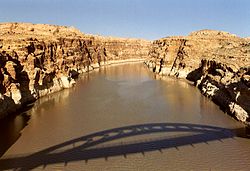
Lees Ferry is a site on the Colorado River in Coconino County, Arizona in the United States, about 7.5 miles (12.1 km) southwest of Page and 9 miles (14 km) south of the Utah–Arizona state line.

The Dirty Devil River is an 80-mile-long (130 km) tributary of the Colorado River, located in the U.S. state of Utah. It flows through southern Utah from the confluence of the Fremont River and Muddy Creek before emptying into the Colorado River at Lake Powell.

The Paria River is a tributary of the Colorado River, approximately 95 miles (153 km) long, in southern Utah and northern Arizona in the United States. It drains a rugged and arid region northwest of the Colorado, flowing through roadless slot canyons along part of its course.

St. Thomas, Nevada is a ghost town in Clark County, Nevada, United States, near where the Muddy River flows into the Colorado River. St. Thomas was purchased by the US Federal Government and abandoned as the waters of Lake Mead submerged the town in the 1930s.
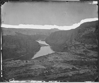
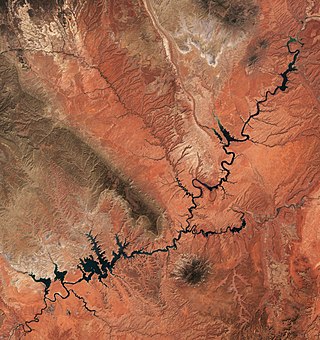
Glen Canyon is a natural canyon carved by a 169.6-mile (272.9 km) length of the Colorado River, mostly in southeastern and south-central Utah, in the United States. Glen Canyon starts where Narrow Canyon ends, at the confluence of the Colorado River and the Dirty Devil River. A small part of the lower end of Glen Canyon extends into northern Arizona and terminates at Lee's Ferry, near the Vermilion Cliffs. Like the Grand Canyon farther downstream, Glen Canyon is part of the immense system of canyons carved by the Colorado River and its tributaries.

Hanksville is a small town in Wayne County, Utah, United States, at the junction of State Routes 24 and 95. The population was 219 at the 2010 census.

State Route 95 or Bicentennial Highway is a state highway located in the southeast of the U.S. state of Utah. The highway is an access road for tourism in the Lake Powell and Cedar Mesa areas, notably bisecting Bears Ears National Monument and providing the only access to Natural Bridges National Monument. The highway does not serve any cities, but the small town of Hanksville is its western terminus. Although the highway has existed since the 1930s as a primitive dirt road, it received its name at its dedication as a paved state highway coincident with the U.S. Bicentennial in 1976. The highway forms part of the Trail of the Ancients National Scenic Byway.

Navajo Mountain is a peak in San Juan County, Utah, with its southern flank extending into Coconino County, Arizona, in the United States. It holds an important place in the traditions of three local Native American tribes. The summit is the highest point on the Navajo Nation.

The Bill Williams River is a 46.3-mile-long (74.5 km) river in west-central Arizona where it, along with one of its tributaries, the Santa Maria River, form the boundary between Mohave County to the north and La Paz County to the south. It is a major drainage westwards into the Colorado River of the Lower Colorado River Valley south of Hoover Dam and Lake Mead, and the drainage basin covers portions of northwest, and west-central Arizona. The equivalent drainage system paralleling the east–west lower reaches of the Bill Williams is the Gila River, which flows east-to-west across central Arizona, joining the Colorado River in the southwest at Yuma. The confluence of the Bill Williams River with the Colorado is north of Parker, and south of Lake Havasu City.

Marble Canyon is an unincorporated community along the Colorado River in Coconino County, Arizona, United States. It is partially located within the Glen Canyon National Recreation Area and the Grand Canyon National Park.

The Colorado River is a major river of the western United States and northwest Mexico in North America. Its headwaters are in the Rocky Mountains where La Poudre Pass Lake is its source. Located in north central Colorado it flows southwest through the Colorado Plateau country of western Colorado, southeastern Utah and northwestern Arizona where it flows through the Grand Canyon. It turns south near Las Vegas, Nevada, forming the Arizona–Nevada border in Lake Mead and the Arizona–California border a few miles below Davis Dam between Laughlin, Nevada and Needles, California before entering Mexico in the Colorado Desert. Most of its waters are diverted into the Imperial Valley of Southern California. In Mexico its course forms the boundary between Sonora and Baja California before entering the Gulf of California. This article describes most of the major features along the river.
Wahweap Creek is a 55.6-mile (89.5 km) long intermittent stream in southern Utah in the United States, and is a tributary of the Colorado River. It drains a rugged, high elevation, largely roadless mesa and canyon country in the Colorado Plateau region. The creek flows into the Lake Powell reservoir at Wahweap Bay where it gives its name to the Wahweap Marina, a popular access point to the Glen Canyon National Recreation Area.
House Rock is a ghost town near the northwest end of the House Rock Valley in northern Coconino County, Arizona, United States. The community was named after the House Rock Valley, which was named by the John Wesley Powell Expedition in 1871.

Gregory Butte is a 4,651-foot elevation sandstone summit located in Glen Canyon National Recreation Area, in San Juan County of southern Utah. It is situated 7.3 miles (11.7 km) northeast of Tower Butte, and 16 miles (26 km) northeast of the town of Page. This iconic landmark of the Lake Powell area towers nearly 1,000 feet above the lake. Before Lake Powell was formed in the 1970s, this butte was set within a meander of the Colorado River. Gregory Butte is a butte composed of Entrada Sandstone. This sandstone, which was originally deposited as sandy mud on a tidal flat, is believed to have formed about 160 million years ago during the Jurassic period as a giant sand sea, the largest in Earth's history. This geographical feature's name was officially adopted in 1977 by the U.S. Board on Geographic Names. Geologist Herbert E. Gregory (1869–1952), mapped much of the bedrock geology of the Colorado Plateau, particularly in geologic monographs concentrating on what is now Navajo Nation land in northern Arizona and southern Utah where this butte is located. According to the Köppen climate classification system, Gregory Butte is located in an arid climate zone with hot, very dry summers, and chilly winters with very little snow.