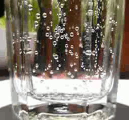
Carbonated water is water containing dissolved carbon dioxide gas, either artificially injected under pressure or occurring due to natural geological processes. Carbonation causes small bubbles to form, giving the water an effervescent quality. Common forms include sparkling natural mineral water, club soda, and commercially produced sparkling water.

The Malvern Hills are in the English counties of Worcestershire, Herefordshire and a small area of northern Gloucestershire, dominating the surrounding countryside and the towns and villages of the district of Malvern. The highest summit affords a panorama of the Severn Valley, the hills of Herefordshire and the Welsh mountains, parts of thirteen counties, the Bristol Channel, and the cathedrals of Worcester, Gloucester and Hereford.

Malvern is a spa town and civil parish in Worcestershire, England. It lies at the foot of the Malvern Hills, a designated Area of Outstanding Natural Beauty. The centre of Malvern, Great Malvern, is a historic conservation area, which grew dramatically in Victorian times due to the natural mineral water springs in the vicinity, including Malvern Water.

Schweppes is a soft drink brand that originated in the Republic of Geneva; it is made, bottled, and distributed worldwide by multiple international conglomerates, depending on licensing and region, that manufacture and sell soft drinks. Schweppes was one of the earliest forms of a soft drink, originally being regular soda water created in 1783. Today, various drinks other than soda water bear the Schweppes brand name, including various types of lemonade and ginger ales.

Great Malvern is an area of the civil parish of Malvern, in the Malvern Hills district, in the county of Worcestershire, England. It lies at the foot of the Malvern Hills, a designated Area of Outstanding Natural Beauty, on the eastern flanks of the Worcestershire Beacon and North Hill, and is the historic centre of Malvern and includes its town centre.

Malvern Wells is a village and civil parish south of Great Malvern in the Malvern Hills district of Worcestershire, England. The parish, once known as South Malvern, was formed in 1894 from parts of the civil parishes of Hanley Castle, Welland, and the former parish of Great Malvern, and owes its development to the 19th-century boom years of Malvern as a spa town. Malvern Wells is a centre of commercial bottling of Malvern water. The population of the parishes of Malvern Wells and Little Malvern was recorded in 2011 as 3,196.

Barnards Green is one of the main population areas of Malvern, Worcestershire, England, situated approximately 1 mile (1.6 km) east and downhill from Great Malvern, the town's traditional centre.

Worcestershire Beacon, also popularly known as Worcester Beacon, or locally simply as The Beacon, is a hill whose summit at 425 metres (1,394 ft) is the highest point in Worcestershire. It is part of the Malvern Hills which run about 13 kilometres (8.1 mi) north-south along the Herefordshire-Worcestershire border.

Great Malvern Priory in Malvern, Worcestershire, England, was a Benedictine monastery and is now an Anglican parish church. In 1949 it was designated a Grade I listed building. It is a dominant building in the Great Malvern Conservation area. It has the largest display of 15th-century stained glass in England, as well as carved misericords from the 15th and 16th century and the largest collection of medieval floor and wall tiles. In 1860 major restoration work was carried out by Sir George Gilbert Scott. It is also the venue for concerts and civic services.

Colwall is a civil parish in Herefordshire, England, situated on the border with Worcestershire, nestling on the western side of the Malvern Hills at the heart of the AONB. Areas of the village are known as Colwall Stone, Upper Colwall which shares a common border at the Wyche Cutting with the Malvern suburb of Malvern Wells, and Colwall Green, spread along 2 miles (3.2 km) of the B4218 road, with the historic village core being 1 mile (1.6 km) to the west of Colwall Stone.

West Malvern is a village and a civil parish on the west side of the north part of the Malvern Hills, on the western edge of Worcestershire, England. It has become effectively a suburb of Malvern and part of an urban area often called The Malverns, locally administered by Malvern Hills District Council and its own parish council. Its altitude up to 250 metres gives West Malvern panoramic views of the Herefordshire countryside to the west. The Church of St James, built in 1840, has an adjacent Church of England primary school. The churchyard includes the grave of Peter Mark Roget, author of Roget's Thesaurus, who died while on holiday in the village. The 2011 Census population of 1,385 was estimated at 1,263 in 2019.

Hartlebury Common is an area of lowland heath in north Worcestershire, England, situated just outside the town of Stourport-on-Severn. Hartlebury Common and Hillditch Coppice are a biological and geological Site of Special Scientific Interest which covers an area of 90.2 hectares . The common supports many varieties of wild plants and insects, especially butterflies and moths. Hartlebury Common and Hillditch Pool are a Local Nature Reserve.

St. Ann's Well is set on the slopes of the Malvern Hills above Great Malvern. It is a popular site on a path leading up to the Worcestershire Beacon and lies on the final descent of the Worcestershire Way. The spring or well is named after Saint Anne, the maternal grandmother of Christ and the patron saint of many wells. A building that dates back to 1813 houses the well or spring. Malvern water flows freely from an elaborately carved water spout. The building also hosts a cafe. During the early 20th century, the now-defunct Burrows company bottled and sold Malvern Water from this source under the "St Ann's Well" brand.

Pitkeathly Wells is a hamlet in the Perth and Kinross area of Scotland, famed for its mineral water. The water was recommended for health during the 19th century, and was bottled for sale, sometimes carbonated. In 1910, Schweppes took over bottling the water, however, they shut down production after a fire.
Malvern water is a natural spring water from the Malvern Hills on the border of the counties of Herefordshire and Worcestershire in England. The Hills consist of very hard granite and limestone rock. Fissures in the rock retain rain water, which slowly permeates through, escaping at the springs. The springs release an average of about 60 litres a minute and the flow has never been known to cease.

Link Top is a locality of Malvern Link, a major population area of the town of Malvern, Worcestershire, England. It is situated at the western extremity of Malvern Link at its boundary with Great Malvern and North Malvern. It is centred on a sharp left hand bend in the Worcester Road (A449) that forms a complex junction with the North Malvern Road, Hornyold Road, Newtown Road, and Lygon Bank,

North Hill is the second highest point of the range of Malvern Hills that runs about 13 kilometres (8.1 mi) north-south along the Herefordshire-Worcestershire border, although North Hill lies entirely within Worcestershire. It has an elevation of 397 metres (1,302 ft), making it the highest point of the Worcestershire Way.

Malvern Water is a brand of bottled drinking water obtained from a spring in the range of Malvern Hills that marks the border between the counties of Herefordshire and Worcestershire in England. The water is a natural spring water from the hills that consist of very hard granite rock. Fissures in the rock retain rain water, which slowly permeates through, escaping at the springs. The springs release an average of about 60 litres a minute. The flow rate depends on rainfall and can vary from as little as 36 litres per minute to over 350 litres per minute.

Rose Garrard is an installation, video and performance artist, sculptor, and author. Garrard's works have been exhibited at the Victoria and Albert Museum, the Tate Gallery, the British Council maintained Great Britain pavilion at the 1984 Venice Biennale, and national galleries in Austria and Canada.
Hillside School was a private preparatory and pre-preparatory boys and girls school in Malvern, Worcestershire, England which was opened in 1870 and closed at the end of 1991 due to lack of demand in the area at the time. In the 1950s and 1960s it was a leading independent school in the area and had around 400 pupils.


