Newland, Worcestershire

Last updated

Newland
Beauchamp Community Alms Houses 1864, Newland.jpg
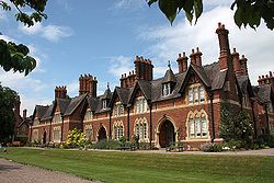
Beauchamp Community alms houses, built 1864, Newland
Worcestershire UK location map.svg
Red pog.svg
Newland
Location within Worcestershire
Population310 
OS grid reference SO796485
Civil parish
  • Newland
District
Shire county
Region
Country England
Sovereign state United Kingdom
Post town MALVERN
Postcode district WR13
Police West Mercia
Fire Hereford and Worcester
Ambulance West Midlands
UK Parliament
  • West Worcestershire
List of places
UK
England
Worcestershire
52°08′04″N2°17′59″W / 52.1344°N 2.2997°W / 52.1344; -2.2997 Coordinates: 52°08′04″N2°17′59″W / 52.1344°N 2.2997°W / 52.1344; -2.2997

Newland is a village and civil parish on the north-eastern edge of Malvern Link, Worcestershire, England, on the A449 road.

Contents

The village lies on the edge of the 6.5 hectare Newland Common, which is protected by the Malvern Hills Conservators and is centred on the traditional English Swan Inn public house. [1] Adjacent to the Swan is a cricket field run as part of Barnards Green Cricket Club. Both the Swan and the cricket field are owned by the Trustees of the Madresfield Estate - a large local landowner. There is no shop or post office in the village.

The population of the parish was 310 in 2011. [2]

Churches and history

The first church at Newland was St Michael's, dating from c1215 and rebuilt in the fifteenth century. It was demolished in 1865.

The St Leonard Chapelry, in Newland is associated with the Beauchamp Community of retired Church of England priests. [3] It was built alongside almshouses on land given by Frederick Lygon, 6th Earl Beauchamp to set up a community based on Anglo-Catholic principles. Originally the almshouses provided homes for retired workers from the Madresfield Estate and for the poor of the parish and now house practising Anglicans and retired clergy from across the country. The chair of trustees is Lady Rosalind Morrison, grand daughter of the 7th Earl Beauchamp and heiress of Madresfield. [4]

Transport

Rail

Rail services are provided from Malvern Link railway station located in Worcester Road about one mile away, with direct services to Worcester, Hereford, Birmingham, Oxford and London.

Alongside the Hereford to Worcester railway line to the north of the village is a former halt, with a signal box and level crossing. This is now a showman site of mobile homes where showpeople live and store their rides, amusements and trade equipment.

Bus

Several local bus services connect Newland with the surrounding area with other routes serving areas further afield including the Malvern to Worcester route 44, 44A, 44B operated by First Diamond serving stops in Malvern Link, Link Top, Great Malvern, and Barnards Green.

Air

The nearest major airport is Birmingham approximately one hour by road via the M5 and M42 motorways. Gloucestershire Airport located at Staverton, in the Borough of Tewkesbury near Malvern is a busy General Aviation airport used mainly for private charter and scheduled flights to destinations such as the islands of Jersey, Guernsey, and the Isle of Man, pilot training, and by the aircraft of emergency services.

Related Research Articles

Malvern, Worcestershire Spa town and civil parish in Worcestershire, England

Malvern is a spa town and civil parish in Worcestershire, England. It lies at the foot of the Malvern Hills, a designated Area of Outstanding Natural Beauty. The centre of Malvern, Great Malvern, is a historic conservation area, which grew dramatically in Victorian times due to the natural mineral water springs in the vicinity, including Malvern Water.

Malvern Hills District Non-metropolitan district in England

Malvern Hills is a local government district in Worcestershire, England. Its council is based in the town of Malvern, and its area covers most of the western half of the county, including the outlying towns of Tenbury Wells and Upton-upon-Severn. It was originally formed in 1974 and was subject to a significant boundary reform in 1998. In the 2011 census the population of the Malvern Hills district was 74,631.

Great Malvern Human settlement in England

Great Malvern is an area of the spa town of Malvern, Worcestershire, England. It lies at the foot of the Malvern Hills, a designated Area of Outstanding Natural Beauty, on the eastern flanks of the Worcestershire Beacon and North Hill, and is the historic centre of Malvern and includes its town centre.

Malvern Wells Human settlement in England

Malvern Wells is a village and civil parish south of Great Malvern in the Malvern Hills district of Worcestershire, England. The parish, once known as South Malvern, was formed in 1894 from parts of the civil parishes of Hanley Castle, Welland, and the former parish of Great Malvern, and owes its development to the 19th-century boom years of Malvern as a spa town. Malvern Wells is a centre of commercial bottling of Malvern water. The population of the parishes of Malvern Wells and Little Malvern was recorded in 2011 as 3,196.

Malvern Link Human settlement in England

Malvern Link is an area of Malvern, Worcestershire, England to the north and east of Great Malvern. The centres of Malvern Link and Great Malvern are separated by Link Common, an area of open land that is statutorily protected by the Malvern Hills Conservators. In 1900 Malvern Link Urban District, which had been formed only five years earlier, merged with Great Malvern to become Malvern Town. The population of Link in 2011 was 6,155.

Barnards Green Human settlement in England

Barnards Green is one of the main population areas of Malvern, Worcestershire, England, situated approximately 1 mile (1.6 km) east and downhill from Great Malvern, the town's traditional centre.

North Malvern Human settlement in England

North Malvern is a suburb of Malvern, Worcestershire, England. It nestles on the northern slopes of the Malvern Hills. It is a contiguous urban extension of Link Top, and other neighbouring centres of population are Great Malvern, Malvern Link, West Malvern and the former village of Cowleigh. It is part of the civil parish of Malvern, administered by the Malvern Hills District, and is included in the informal region known as The Malverns.

West Malvern Human settlement in England

West Malvern is a village and a civil parish on the west side of the north part of the Malvern Hills, on the western edge of Worcestershire, England. It has become effectively a suburb of Malvern and part of an urban area often called The Malverns, locally administered by Malvern Hills District Council and its own parish council. Its altitude up to 250 metres gives West Malvern panoramic views of the Herefordshire countryside to the west. The Church of St James, built in 1840, has an adjacent Church of England primary school. The churchyard includes the grave of Peter Mark Roget, author of Roget's Thesaurus, who died while on holiday in the village. The 2011 Census population of 1,385 was estimated at 1,263 in 2019.

Madresfield Human settlement in England

Madresfield is a village and civil parish in the administrative district of Malvern Hills in the county of Worcestershire, England. It is located about two miles east of Malvern town centre at the foot of the Malvern Hills and is less than two miles from the River Severn. Surrounded by farms and common land, it has a clear view of the entire range of the Malvern Hills, and is part of the informal region referred to as The Malverns.

Frederick Lygon, 6th Earl Beauchamp

Frederick Lygon, 6th Earl Beauchamp PC DL, styled The Honourable Frederick Lygon between 1853 and 1866, was a British Conservative politician.

Madresfield Court

Madresfield Court is a country house in Malvern, Worcestershire, England. The home of the Lygon family for nearly six centuries, it has never been sold and has passed only by inheritance since the 12th century; a line of unbroken family ownership reputedly exceeded in length in England only by homes owned by the British Royal Family. The present building is largely a Victorian reconstruction, although the origins of the present house are from the 16th century, and the site has been occupied since Anglo-Saxon times. The novelist Evelyn Waugh was a frequent visitor to the house and based the family of Marchmain, who are central to his novel Brideshead Revisited, on the Lygons. Surrounded by a moat, the Court is a Grade I listed building.

Great Malvern railway station Grade II listed station in Great Malvern, Worcestershire, England

Great Malvern railway station is one of two stations serving the town of Malvern, Worcestershire, England on the Hereford to Worcester section of the Cotswold Line. It is situated downhill from the centre of Great Malvern and close to Barnards Green. The station retains most of its original Victorian station design by the architect Edmund Wallace Elmslie and is a Grade II listed building.

Callow End Human settlement in England

Callow End is a constituent village of the civil parish of Powick in the Malvern Hills District of Worcestershire, England. It is located on the B4424 road about 1 mile (1.6 km) to the south of its junction with the main A449 Malvern to Worcester road.

St Johns, Worcester Human settlement in England

St John's is a suburb of Worcester, England, lying west of the city centre and the River Severn. St. John's is referred to locally as the "Village in the City", which is partly due to being an independent township, before joining the city in 1837. Although there is still a strong sense of pride and identity within the community.

The Worcester and Hereford Railway started the construction of a standard gauge railway between the two cities in 1858. It had needed the financial assistance of larger concerns, chiefly the Oxford, Worcester and Wolverhampton Railway, and the Newport, Abergavenny and Hereford Railway. It opened its line progressively from 1859 to 1861, delayed by exceptionally difficult tunnelling at Colwall and Ledbury. The company was purchased by the West Midland Railway in 1860, and that company amalgamated with the Great Western Railway in 1863.

Poolbrook Human settlement in England

Poolbrook is a village and a suburb of Malvern, Worcestershire, England, situated approximately 1.5 miles (2.4 km) southeast of Great Malvern, the town's centre, and about 0.5 miles (08 km) from the Malvern suburb of Barnards Green on the Poolbrook Road (B4208). The village comprises several shops, a traditional English pub, and a number of council and private housing estates. St Andrew's C of E parish church was built in Early English style in 1882 as a memorial to a member of the Chance Brothers glass manufacturing family. The village occupies the geographical centre of the Chase ward of Malvern Town Council.

Among the places of worship in the town and area of Malvern, Worcestershire are centres of dedication to many faiths and denominations. The town has 31 Christian churches with 11 belonging to the Church of England, ranging from low church to high Anglo-Catholic, two Roman Catholic, one Evangelical, and the others being Non-Conformist and other faiths. Its oldest place of worship is Great Malvern Priory which is all that remains of the former 10th century abbey of which according to the Worcester Monastic Annals, work began in 1085. The chain of Malvern Hills lies in a north-south direction, thus posing a challenge for the architects of Christian churches located on the steep slopes, chancels being traditionally sited at the east end of the building. Many churches were built in the 19th century concomitant with the rapid expansion of the town due to its popularity as a spa. A few modern buildings such as St Mary's Church (1960) in Sherrard's Green, have been constructed in the second half of the 20th century, and some churches, notably St Andrews in Poolbrook, have had important modern extensions added during the first decade of the 21st century.

Link Top Human settlement in England

Link Top is a locality of Malvern Link, a major population area of the town of Malvern, Worcestershire, England. It is situated at the western extremity of Malvern Link at its boundary with Great Malvern and North Malvern. It is centred on a sharp left hand bend in the Worcester Road (A449) that forms a complex junction with the North Malvern Road, Hornyold Road, Newtown Road, and Lygon Bank,

Sherrards Green Human settlement in England

Sherrard's Green is a village and a suburb of Malvern, Worcestershire, England, situated approximately 1.5 miles southeast of Great Malvern, the town's centre, and about 0.5 miles (0.80 km) from the Malvern suburb of Barnards Green. The village comprises a number of council and private housing estates and the small parish church of St Mary's, Pickersleigh, and a Tesco convenience store that opened in 2011 on the site of a former pub, The New Gas Tavern.

References

  1. Retirement of Swan landlord Retrieved 24 May 2009.
  2. Neighbourhood Statistics
  3. St. Leonards, Newland, The Chapel of the Beauchamp Community, Malvern Retrieved 23 October 2010
  4. "The Beauchamp Community at Newland and St Leonard's Church".