
Worcestershire is a ceremonial county in the West Midlands of England. It is bordered by Shropshire, Staffordshire, and the West Midlands county to the north, Warwickshire to the east, Gloucestershire to the south, and Herefordshire to the west. The city of Worcester is the largest settlement and the county town.

Malvern is a spa town and civil parish in Worcestershire, England. It lies at the foot of the Malvern Hills, a designated Area of Outstanding Natural Beauty. The centre of Malvern, Great Malvern, is a historic conservation area, which grew dramatically in Victorian times due to the natural mineral water springs in the vicinity, including Malvern Water.
Malvern Hills is a local government district in Worcestershire, England. Its council is based in Malvern, the district's largest town. The district also includes the towns of Tenbury Wells and Upton-upon-Severn and a large rural area covering much of the western side of the county, including numerous villages. The district is named after the Malvern Hills, which are a designated Area of Outstanding Natural Beauty.

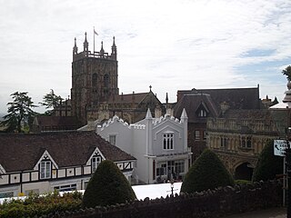
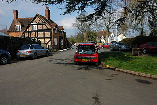
Great Malvern is an area of the civil parish of Malvern, in the Malvern Hills district, in the county of Worcestershire, England. It lies at the foot of the Malvern Hills, a designated Area of Outstanding Natural Beauty, on the eastern flanks of the Worcestershire Beacon and North Hill, and is the historic centre of Malvern and includes its town centre.
Lindridge is a village and civil parish in the Malvern Hills District in the north of the county of Worcestershire, England, near the Shropshire border and the town of Tenbury Wells. The parish is extensive, and includes the hamlets of Eardiston, Lindridge, and Frith Common. The area around the village is known for its extensive hop fields.

Malvern Wells is a village and civil parish south of Great Malvern in the Malvern Hills district of Worcestershire, England. The parish, once known as South Malvern, was formed in 1894 from parts of the civil parishes of Hanley Castle, Welland, and the former parish of Great Malvern, and owes its development to the 19th-century boom years of Malvern as a spa town. Malvern Wells is a centre of commercial bottling of Malvern water. The population of the parishes of Malvern Wells and Little Malvern was recorded in 2011 as 3,196.

The area now known as Worcestershire has had human presence for over half a million years. Interrupted by two ice ages, Worcestershire has had continuous settlement since roughly 10,000 years ago. In the Iron Age, the area was dominated by a series of hill forts, and the beginnings of industrial activity including pottery and salt mining can be found. It seems to have been relatively unimportant during the Roman era, with the exception of the salt workings.

Deeping St James is a large village in the South Kesteven district of Lincolnshire, England. The population of the civil parish was reported as 7,051 at the 2011 census.
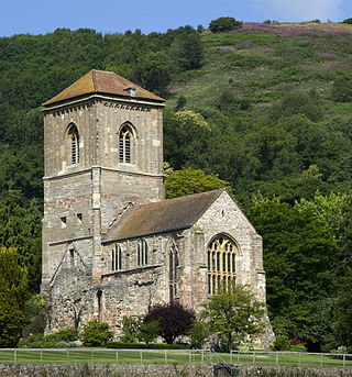
Little Malvern Priory, in the village of Little Malvern near Malvern, Worcestershire, was a Benedictine monastery c. 1171–1537. It was founded from Worcester Cathedral. Little remains of the 12th-century church, which was rebuilt in 1480–1482. The site is now occupied by a house named Little Malvern Court, which has limited public opening. The present building comprises a medieval chancel and crossing tower, and a modern west porch on the site of the east bays of the nave. The transepts and the two chapels flanking the choir are in ruins. The grade I listed Little Malvern Priory church, dedicated to St Giles, is adjacent.

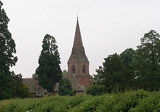
Great Malvern Priory in Malvern, Worcestershire, England, was a Benedictine monastery and is now an Anglican parish church. In 1949 it was designated a Grade I listed building. It is a dominant building in the Great Malvern Conservation area. It has the largest display of 15th-century stained glass in England, as well as carved misericords from the 15th and 16th century and the largest collection of medieval floor and wall tiles. In 1860 major restoration work was carried out by Sir George Gilbert Scott. It is also the venue for concerts and civic services.

Kempsey is a village and civil parish in the Malvern Hills District in the county of Worcestershire, England. It is bounded by the River Severn on the west, and the A38 main road runs through it and is about 3 miles (5 km) south of Worcester. The village has a long history. Its name is derived from the Saxon "Kemys' Eye", or the island of Kemys. Kemys was a Saxon chief, whose island lay between marshes and the River Severn. One of the roads in Kempsey, Lyf's Lane, is named after another Saxon chief. The village was recorded in the 11th century Domesday Book as having a value of £7.
Great Witley is a village and civil parish in the Malvern Hills District in the northwest of the county of Worcestershire, England. It is situated around ten miles to the north west of the city of Worcester. The parish had a population of 743 in 2021.

Madresfield is a village and civil parish in the administrative district of Malvern Hills in the county of Worcestershire, England. It is located about two miles east of Malvern town centre at the foot of the Malvern Hills and is less than two miles from the River Severn. Surrounded by farms and common land, it has a clear view of the entire range of the Malvern Hills, and is part of the informal region referred to as The Malverns.

Eldersfield is a village and civil parish in the Malvern Hills district of Worcestershire, England. It had a population of 584 in 2021.
Little Witley is a village and civil parish in the Malvern Hills District in the county of Worcestershire, England.
Hanley Castle is a village and civil parish in Worcestershire, England, between the towns of Malvern and Upton upon Severn and a short distance from the River Severn. It lies in the administrative area of Malvern Hills District, and is part of the informal region known as The Malverns. It is served primarily by bus service 332 Worcester - Upton upon Severn - Hanley Castle operated by Aston Coaches and 363 Worcester - Tewkesbury operated by First Worcester.

Welland is a village and civil parish in the administrative district of Malvern Hills in the county of Worcestershire, England. It has a combined parish council with Little Malvern, with 9 of the 11 councillors. It is about 6 miles (9.7 km) from the town of Malvern, 15 miles from the city of Worcester, and 18 miles from the city of Gloucester. It is surrounded by farms and common land, and is part of the informal region referred to as The Malverns.
Wichenford is a village and civil parish in the Malvern Hills District in the county of Worcestershire, England. It lies 7 miles (11 km) to the north-west of the city of Worcester and has a population of c 400 for around 250 households. Primary education is provided at nearby Hallow, and at Martley, which also has a secondary school.
Among the places of worship in the town and area of Malvern, Worcestershire are centres of dedication to many faiths and denominations. The town has 31 Christian churches with 11 belonging to the Church of England, ranging from low church to high Anglo-Catholic, two Roman Catholic, one Evangelical, and the others being Non-Conformist and other faiths. Its oldest place of worship is the almost cathedral sized parish church of Great Malvern Priory which is all that remains of the former 10th century abbey in central Malvern, which according to the Worcester Monastic Annals, work began in 1085. The chain of Malvern Hills lies in a north-south direction, thus posing a challenge for the architects of Christian churches located on the steep slopes, chancels being traditionally sited at the east end of the building. Many churches were built in the 19th century concomitant with the rapid expansion of the town due to its popularity as a spa. A few modern buildings such as St Mary's Church (1960) in Sherrard's Green, have been constructed in the second half of the 20th century, and some churches, notably St Andrews in Poolbrook, have had important modern extensions added during the first decade of the 21st century.

St Wulstan's Roman Catholic Church, Little Malvern, Worcestershire, England is a Benedictine parish church administered by the monks of Downside Abbey. The attached churchyard contains the grave of the composer Edward Elgar and of his wife, Alice. The church was designed in 1862 in a Gothic Revival style by Benjamin Bucknall. It is a Grade II listed building. The Elgars' grave has a separate Grade II listing.

