Bransford

Last updated

Bransford
Bransford - Powick junction - geograph.org.uk - 837280.jpg
Bransford – Powick junction
Worcestershire UK location map.svg
Red pog.svg
Bransford
Location within Worcestershire
Population527 (2021 Census)
OS grid reference SO791525
  London 105 miles (169 km)
Civil parish
  • Bransford
District
Shire county
Region
Country England
Sovereign state United Kingdom
Post town WORCESTER
Postcode district WR6
Dialling code 01886
Police West Mercia
Fire Hereford and Worcester
Ambulance West Midlands
List of places
UK
England
Worcestershire
52°10′00″N2°19′00″W / 52.166667°N 2.316667°W / 52.166667; -2.316667 Coordinates: 52°10′00″N2°19′00″W / 52.166667°N 2.316667°W / 52.166667; -2.316667

Bransford is a village and civil parish in the Malvern Hills district of the county of Worcestershire, England. It is situated close to the River Teme and the village of Leigh. It is on the primary route between Worcester and Hereford, the A4103 that runs through the centre of the village. According to the 2021 census, Bransford has a population of 527. [1] The parish shares its parish council with Leigh.

Contents

The main church in Bransford is St. John the Baptist Church, a small Norman building that is lit by candlelight. [2] Bransford is part of the West Worcestershire parliamentary constituency and its current Member of Parliament is Harriett Baldwin, who is a Conservative representative. [3]

History

A map showing Bransford in the 19th century Bransford 19th century map.PNG
A map showing Bransford in the 19th century

The origins of the name 'Bransford' are uncertain, but it is believed to mean 'hill-top ford' or 'ford at Bragen'. This is derived from 'braegen', old English for crown of the head or topographically a hill and then 'ford'. [4] In the Doomsday Book, Bransford was called Bradnesforde and included information about Urso from the Pershore Church and mill. [5] Bransford was home to Wulstan de Bransford, the Bishop of Worcester from 1338 to 1349. [6] Following the Poor Law Amendment Act 1834 Bransford Parish ceased to be responsible for maintaining the poor in its parish, a responsibility transferred to Martley Poor Law Union. [7] In the 1870s, Bransford was described as

"...a chapelry in Leigh parish, Worcestershire; on the river Teme, adjacent to the Malvern railway, 4½ miles SW by W of Worcester. [8] "

Occupation

1881 occupational structure of Bransford, Worcestershire, as reported by 1881 census 1881 Bransford occupational structure.jpg
1881 occupational structure of Bransford, Worcestershire, as reported by 1881 census

It was in 1894 that Bransford was separated from Leigh as an ecclesiastical parish and made into a civil parish of its own right. [6] Bransford was once devoted to pasture and had 2,366 acres of arable land as well as a further 1,062 separate acres of land. [6] There was once a clothing factory by the Teme, explaining why 7 women worked in dress in 1881. [9] There was also a snuff-mill, which then became a corn-mill. [6] When the clothing factory and snuff-mill disappeared, people became involved heavily in agriculture, which explains why in 1881 at least 46 people were engaged in agriculture as their occupation. [9] It was at this time that men were involved in agriculture, whilst women were working in occupations such as domestic services (12 women) and dress services (4 women). Ninety women that lived in Bransford had an unspecified occupation, which was representative of the time. [9] Today, there are 186 residents in employment. [10] 8 people now work in agriculture, compared to 46 in 1881. Wholesale and retail trade now has the highest level of works in Bransford, with 35 people (18.8% of employment) working in this field. [10] Human health and social work has the second highest level of employment in Bransford with jobs in education being third highest. [10] This shows a huge change from 1881 where the majority of jobs were in agriculture, mining and domestic services.

Population and Age

Total Population of Bransford Civil Parish, Worcestershire, as reported by the Census of Population from 1881 to 2011 Bransford population time series 1881-2011.jpg
Total Population of Bransford Civil Parish, Worcestershire, as reported by the Census of Population from 1881 to 2011

The population of Bransford has steadily increased since 1881. There was a slight decrease in 1891 but then it continued to increase until 1911. In 1911, the population was at 263 but this then steeply dropped to 198 in 1921. [11] This was most likely due to World War 1 leading to a vast decrease in population. Since 1961, there has been a sharper increase in population, going from 267 to 389 today. [11] It is important to note that there was no census information between 1961 and 2001, so there may have been changes here that were not recorded. Today, the population may be increasing due to a growing population, as well as the growing number of businesses in Bransford. In 1881 there were 129 males and 128 females living in Bransford. [12] This has changed quite drastically today, as there are 266 males and 264 females. [1] Due to this rise in population there was an increase in housing, going from 62 houses in 1881 [13] compared with the 171 households there are in Bransford today. [14]

The mean age in Bransford is 49.4 and the median age is 53. The largest age bracket is 45–59 years old, as 23.9% of people in Bransford are of this age. [15]

Transport

Bransford lies on the A4103 road, making it accessible. It is served by the 417 [16] and 423 [17] bus services [18] and the nearest train station is Worcester Foregate Street. [19] Until 1965, there was a Great Western Railway station on the Bransford Road. It closed on 5 April 1965, possibly from lack of need. [20] For many, having a car or van is the main method of transport as out of the 171 households, 161 own at least one car or van. [14] Bransford's nearest motorway is the M5.

View of River Teme, situated in Bransford River Teme near Bransford - geograph.org.uk - 634238.jpg
View of River Teme, situated in Bransford
The old Great Western Railway station Bransford Road Station 1931107.jpg
The old Great Western Railway station

Local businesses

Today, Bransford is home to a number of small businesses.

Related Research Articles

<span class="mw-page-title-main">Worcestershire</span> County of England

Worcestershire is a county in the West Midlands of England. The area that is now Worcestershire was absorbed into the unified Kingdom of England in 927, at which time it was constituted as a county.

<span class="mw-page-title-main">River Teme</span> River in Wales and England

The River Teme rises in Mid Wales, south of Newtown, and flows southeast roughly forming the border between England and Wales for several miles through Knighton before entering England in the vicinity of Bucknell and continuing east to Ludlow in Shropshire. From there, it flows to the north of Tenbury Wells on the Shropshire/Worcestershire border on its way to join the River Severn south of Worcester. The whole of the River Teme was designated as an SSSI by English Nature in 1996.

<span class="mw-page-title-main">Malvern Hills District</span> Non-metropolitan district in England

Malvern Hills is a local government district in Worcestershire, England. Its council is based in the town of Malvern, and its area covers most of the western half of the county, including the outlying towns of Tenbury Wells and Upton-upon-Severn. It was originally formed in 1974 and was subject to a significant boundary reform in 1998. In the 2011 census the population of the Malvern Hills district was 74,631.

<span class="mw-page-title-main">Shelsley Walsh</span> Village and civil parish in Worcestershire, England

Shelsley Walsh is a small village and civil parish in Worcestershire, England, on the western side of the River Teme. For administrative purposes it is presently located in the Teme Valley ward of the county’s Malvern Hills district. In the 2011 Census there was an estimated population of 28 people in 12 households. The site has been farmed since Anglo Saxon times and there are also vestiges of former industry, but it is now best known for its association with the Shelsley Walsh Speed Hill Climb.

<span class="mw-page-title-main">Blakedown</span> Human settlement in England

Blakedown is a village in the Wyre Forest District lying along the A456 in the north of the county of Worcestershire, England. Following enclosures and the arrival of the railway, it developed both agriculturally and industrially during the 19th century. Due to its transport links, it now serves mainly as a dormitory for the neighbouring town of Kidderminster and for the cities of Birmingham and Worcester.

<span class="mw-page-title-main">Ashleyhay</span> Human settlement in England

Ashleyhay is a village and civil parish in the Amber Valley district of Derbyshire, England, about five miles north-west of Belper. It is also situated one and three-quarters of a mile south of Wirksworth and eleven miles north of Derby city centre. According to the 2001 census it had a population of 105, increasing to 118 at the 2011 Census.
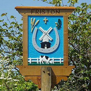
<span class="mw-page-title-main">Darenth</span> Human settlement in England

Darenth is a village and civil parish in the Borough of Dartford, Kent, England. It is located 3.4 miles south east of Dartford and 4.6 miles north east of Swanley.

<span class="mw-page-title-main">Tingrith</span> Human settlement in England

Tingrith is a small village and civil parish in Bedfordshire, England. It is located adjacent to the M1 motorway near the large village of Toddington. The nearest major town is Luton, located about 10 miles (16 km) to the southeast. The parish church of St Nicholas dates back to the 13th century and has Tingrith's only cemetery. The church can seat up to 200 people.

<span class="mw-page-title-main">Langdon, Kent</span> Human settlement in England

Langdon is a civil parish in the Dover district of Kent, England, and contains the villages of East Langdon and West Langdon, and the hamlets of Martin and Martin Mill. Langdon was the site of Langdon Abbey which was dissolved in 1535.

<span class="mw-page-title-main">Clifton upon Teme</span> Human settlement in England

Clifton upon Teme is a village and civil parish in the Malvern Hills District in the county of Worcestershire, England.

<span class="mw-page-title-main">Newborough, Cambridgeshire</span> Human settlement in England

Newborough is a village and a civil parish in the Peterborough district, in the ceremonial county of Cambridgeshire, England. Newborough is situated 7.62 km (4.74 mi) north of Peterborough. Newborough has a population of 1,670 according to the 2011 census

<span class="mw-page-title-main">Pensax</span> Human settlement in England

Pensax is a village and civil parish of northwest Worcestershire in England, incorporating the hamlet of Menithwood to the west of Pensax Common. According to the 2001 census, the parish had a population of 317.

<span class="mw-page-title-main">Clopton, Suffolk</span> Human settlement in England

Clopton is a village and civil parish in Suffolk. It is located between Ipswich and Debenham two kilometres north of Grundisburgh on the River Lark. The village is no larger than a series of houses either side of the B1078, surrounded by farm land. The village itself has no clear centre; houses and other buildings are concentrated around the four manors of Kingshall, Brendhall, Rousehall and Wascolies, all of which are mentioned in the Domesday Book of 1086.

<span class="mw-page-title-main">Fakenham Magna</span> Human settlement in England

Fakenham Magna is a village and civil parish in the West Suffolk district of Suffolk in eastern England. The meaning of the word 'Fakenham' can be split into two: 'Faken' and 'ham', both of which derive from Old English. The former refers to somebody by the name of 'Facca', with the latter meaning 'a village / a homestead', making the direct translation 'Facca's homestead'. 'Magna' translates from Latin as 'great', hence the alternative name of the village of 'Great Fakenham'. During World War Two, however, the village was referred to as 'Little Fakenham', which was used to avoid confusion with the larger civil parish of Fakenham in Norfolk.
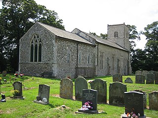
<span class="mw-page-title-main">Rochford, Worcestershire</span> Human settlement in England

Rochford consists of two hamlets, Lower and Upper Rochford. A civil parish in the Malvern Hills District near Tenbury Wells, in the county of Worcestershire, England, Rochford is 18 miles (29 km) NW of Worcester. The River Teme, which rises in Wales, flows past Lower Rochford and joins the River Severn in Worcester. The chapelry of Rochford was an exclave of Herefordshire, part of the hundred of Wolphy. It was transferred by the Counties Act 1844 to Worcestershire.

<span class="mw-page-title-main">Tibenham, Norfolk</span> A village and civil parish in Norfolk, England

Tibenham is a village and civil parish located in the Depwade district of South Norfolk, England. The parish is 2 miles (3.2 km) north west of Tivetshall railway station. It has a public house called The Greyhound.

<span class="mw-page-title-main">Swilland</span> Human settlement in England

Swilland is a village and civil parish, in the East Suffolk district, in the English county of Suffolk. It is north of the large town of Ipswich. Swilland has a church called St Mary's Church and a pub called The Moon & Mushroom Inn which has been awarded Suffolk Pub of The Year on two occasions by the Evening Star. Swilland shares a parish council with Witnesham called "Swilland and Witnesham Grouped Parish Council".

<span class="mw-page-title-main">Huntingfield, Suffolk</span> Human settlement in England

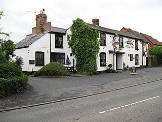
Huntingfield is a village near the B1117 road, in the East Suffolk district, in the county of Suffolk, England. The village is close to the source of the River Blyth and the parish is 12 miles from the seaside town of Southwold. Nearby settlements include the town of Halesworth and the villages of Walpole, Heveningham, Cookley and Laxfield.

<span class="mw-page-title-main">Standon, Staffordshire</span> Human settlement in England

Standon is a village and civil parish in the Stafford district, in the county of Staffordshire, England. Standon has a church called Church of All Saints and one school called All Saints C of E First School. In 2001 the population of the civil parish of Standon was 823, and in the 2011 census it had a population of 879.

<span class="mw-page-title-main">Linton (near Bromyard)</span> Human settlement in England

Linton is a civil parish in north-east of Herefordshire, England, and is approximately 14 miles (23 km) north-east from the city and county town of Hereford. The closest town is Bromyard, conjoined to the parish at the west. The parish includes the public open land of Bringsty Common at its north-east, and the hamlet of Linley Green.

References

  1. 1 2 "Bransford". City population. Retrieved 14 April 2023.
  2. Leach, Andrew. "Parish Finder". www.achurchnearyou.com. Crown. Archived from the original on 4 March 2016. Retrieved 9 February 2016.
  3. "parliament.uk". Harriett Baldwin MP. Retrieved 3 March 2016.
  4. Ekwall, E.; Mills, A. D. "Key to English Place-Names". Key to English Place-Names. Retrieved 28 February 2016.
  5. "Worchestershire A-D". The Domesday Book Online. domesdaybook.co.uk. Retrieved 24 March 2016.
  6. 1 2 3 4 Page, William; Willis-Bund, J W (1924). "Leigh with Bransford". A History of the County of Worcester.
  7. Worcestershire Family History Guidebook, Vanessa Morgan, 2011, p68 The History Press, Stroud, Gloucestershire.
  8. Wilson, John Marius (1870–72). Imperial Gazetteer of England Wales. Edinburgh: A. Fullerton & Co.
  9. 1 2 3 Woollard, Matthew. "1881 Census of England and Wales, Tables: Ages, Condition as to Marriage, Occupations and Birthplaces of people, Table 10: " Occupations of Males and Females in the Division and its Registration Counties"". A Vision of Britain. Retrieved 25 February 2016.
  10. 1 2 3 "Bransford (Parish): Key Figures for 2011 Census: Industry". Neighbourhood Statistics. Office for National Statistics. Retrieved 17 March 2016.
  11. 1 2 "Population Statistics | Total Population, A Vision of Britain through Time". GB Historical GIS / University of Portsmouth, Bransford Ch/CP through time. Retrieved 8 March 2016.
  12. "A Vision of Britain through Time". Bransford Ch/CP through time, Population Statistics, Males & Female. GB Historical GIS / University of Portsmouth. Retrieved 17 March 2016.
  13. "A Vision of Britain Housing Statistics". A Vision of Britain. GB Historical GIS / University of Portsmouth. Retrieved 19 March 2016.
  14. 1 2 "Car and Van Availability, 2011". Neighbourhood Statistics. Office for National Statistics. Retrieved 3 March 2016.
  15. "Bransford (Parish): Age Structure, 2011". Neighbourhood Statistics. Office for National Statistics. Retrieved 24 March 2016.
  16. "Bus timetable, Astons of Kempsey". Traveline Midlands. Retrieved 13 March 2016.
  17. "Bus timetable, LMS Travel". Traveline Midlands. Retrieved 13 March 2016.
  18. Traveline. "for journeys within the South, East and West Midlands". traveline west midlands. Retrieved 25 February 2016.
  19. "Google Maps" . Retrieved 25 February 2016.
  20. Brooksbank, Ben. "Bransford Road Station". Geograph. Retrieved 25 February 2016.
  21. Gogarty, Jeff. "New House Farm, Bransford, Worcestershire". Geograph. Retrieved 25 February 2016.
  22. Fareham, Steve. "Bank House hotel car park". Geograph. Retrieved 25 February 2016.
  23. Allen, Chris. "Fox Inn, Bransford". Geograph. Retrieved 25 February 2016.
  24. Rickard, Trevor. "Bransford Nursery". Geograph. Retrieved 25 February 2016.
  25. "Gilbert's Farm". Gilberts Farm. Fisher German. Archived from the original on 26 March 2016. Retrieved 17 March 2016.