Abberley

Last updated

Abberley
Abberley DSC00296.JPG
Worcestershire UK location map.svg
Red pog.svg
Abberley
Location within Worcestershire
Population788 
OS grid reference SO745675
  London 112 miles (180 km)
Civil parish
  • Abberley
District
Shire county
Region
Country England
Sovereign state United Kingdom
Post town WORCESTER
Postcode district WR6
Dialling code 01299
Police West Mercia
Fire Hereford and Worcester
Ambulance West Midlands
UK Parliament
List of places
UK
England
Worcestershire
52°18′00″N2°22′00″W / 52.3°N 2.366667°W / 52.3; -2.366667

Abberley is a village and civil parish in north west Worcestershire, England.

Contents

It is situated on the northern slopes of Abberley Hill, which is 283 metres (928 ft) tall, between the River Severn and River Teme. The civil parish had a population of 788 in the 2021 census. [1]

Location

Abberley lies halfway between Worcester and Tenbury, at the junction with the road from Worcester to Cleobury Mortimer. The parish was described in 1905 as being "about six miles in length, and nowhere more than one mile in breadth". [2] At the 2001 census, it had the youngest population of any Worcestershire village. [3]

The village

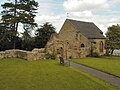
Abberley is a village of three distinct parts. The oldest part, known as The Village, clusters around the 12th century and 13th century parish church of St. Michael. To the west, and divided from the Village by farmland and the Cleobury road, is The Common, where the largest part of the population lives, new housing is being added, and there is a village shop-cum-post office. Between the Village and the Common, on the Cleobury road, are the Parochial VC primary school [4] and the Village Hall. [5]

Overlooking the village is the third part of Abberley, The Hill, with scattered farms, houses and cottages across the steep slopes of Abberley Hill.

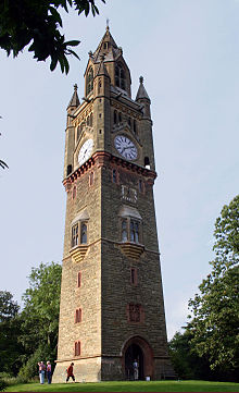
On the far side of Abberley Hill from the village, to the south of the Worcester-Tenbury road, lies Abberley Hall. Abberley Hill forms part of the Abberley and Malvern Hills Geopark. The Hill lies on the path of the Worcestershire Way, [6] a long-distance hiking trail.

Abberley has two churches, a primary school, a modern village hall, and nearby a country hotel and restaurant, The Elms.

Abberley Clock Tower Abberley Clock Tower.jpg
Abberley Clock Tower

Abberley Hall School, a preparatory school set in the grounds of Abberley Hall, closed on 1 July 2023. [7] Abberley Clock Tower is the setting for the children's book by Gene Kemp, The Clock Tower Ghost. [8]

History

The name Abberley probably relates to the 6th century Saxon chief Eobald, by way of Eobaldelega, then Eobaldsleigh. [9] According to The Cambridge Dictionary of English Place-names, Abberley is derived from 'Eadbald's wood or clearing' (Eadbald + lēah). [10] Abberley is recorded in the Domesday Book of 1086–7 as Edboldelege, when it was held by Ralph de Tosny, [11] and was later recorded as Albodeslega in c.1150, Abbedeslegh in 1216, Ab(b)ot(t)eley(e) in 1346-1485 and Aberley in 1480. [10]

In 1405 Abberley Hill was at the centre of a protracted stand-off between two major armies, that of Henry IV camped on Abberley Hill itself and the primarily Welsh army of Owain Glyndŵr camped on nearby Woodbury Hill. Eventually, cut off from their supply line, the Welsh withdrew, never again to penetrate so far into England.

Abberley was in the upper division of Doddingtree Hundred. [12]

On 10 March 1803 Colonel Henry Bromley inherited the Manorship of Abberley. As he had no son, on his death in 1836, the manor was put up for sale by his executors and bought by John Lewis Moilliet of Geneva. He built a new house, Abberley Hall, but he died in 1845 before it was completed. [13]

Following the Poor Law Amendment Act 1834 Abberley Parish ceased to be responsible for maintaining the poor in its parish. This responsibility was transferred to Martley Poor Law Union. [14]

Churches

St. Mary's Church Abberley St Mary's Church DSC00298.JPG
St. Mary's Church

A little to the north, across the Green (developed as a Millennium project) from the village, is the large Victorian St. Mary's church, built between 1850 and 1852. It was designed by John Jenkins Cole and enlarged by the same architect in 1877 following a fire in January 1873. [15]

It was built to replace St. Michael's church when the latter fell into disrepair, though the chancel of St. Michael's was later restored and is still used for some services.

People

Related Research Articles

<span class="mw-page-title-main">River Teme</span> River in Wales and England

The River Teme rises in Mid Wales, south of Newtown, and flows southeast roughly forming the border between England and Wales for several miles through Knighton before entering England in the vicinity of Bucknell and continuing east to Ludlow in Shropshire. From there, it flows to the north of Tenbury Wells on the Shropshire/Worcestershire border on its way to join the River Severn south of Worcester. The whole of the River Teme was designated as an SSSI by English Nature in 1996.

<span class="mw-page-title-main">Stourport-on-Severn</span> Human settlement in England

Stourport-on-Severn, often shortened to Stourport, is a town and civil parish in the Wyre Forest District of North Worcestershire, England, a few miles to the south of Kidderminster and downstream on the River Severn from Bewdley. At the 2021 census, it had a population of 20,653.

<span class="mw-page-title-main">Tenbury Wells</span> Human settlement in England

Tenbury Wells is a market town and civil parish in the northwestern extremity of the Malvern Hills District of Worcestershire, England. Its northern border adjoins Shropshire, and at the 2021 census joint with Burford it had a population of 5,224.

<span class="mw-page-title-main">Selly Oak</span> Human settlement in England

Selly Oak is an industrial and residential area in south-west Birmingham, England. The area gives its name to Selly Oak ward and includes the neighbourhoods of: Bournbrook, Selly Park, and Ten Acres. The adjoining wards of Edgbaston and Harborne are to the north of the Bourn Brook, which was the former county boundary, and to the south are Weoley, and Bournville. A district committee serves the four wards of Selly Oak, Billesley, Bournville and Brandwood. The same wards form the Birmingham Selly Oak constituency, represented since 2010 by Steve McCabe (Labour). Selly Oak is connected to Birmingham by the Pershore Road (A441) and the Bristol Road (A38). The Worcester and Birmingham Canal and the Birmingham Cross-City Railway Line run across the Local District Centre.

<span class="mw-page-title-main">Cleobury Mortimer</span> Human settlement in England

Cleobury Mortimer is a market town and civil parish in south-east Shropshire, England, which had a population of 3,036 at the 2011 census. It was granted a market charter by King Henry III in 1226.

<span class="mw-page-title-main">Great Witley</span> Human settlement in England

Great Witley is a village and civil parish in the Malvern Hills District in the northwest of the county of Worcestershire, England. It is situated around ten miles to the north west of the city of Worcester. The parish had a population of 743 in 2021.

<span class="mw-page-title-main">Hagley</span> Village in Worcestershire, England

Hagley is a village and civil parish in Worcestershire, England. It is on the boundary of the West Midlands and Worcestershire counties between the Metropolitan Borough of Dudley and Kidderminster. Its estimated population was 7,162 in 2019.

<span class="mw-page-title-main">Abberley Hall</span>

Abberley Hall is a country house in the north-west of the county of Worcestershire, England. The present Italianate house is the work of Samuel Daukes and dates from 1846 to 1849. Since 1916 it has been occupied by Abberley Hall School. It is a Grade II* listed building. The gardens are listed as Grade II on the English Heritage Register of Historic Parks and Gardens of Special Historic Interest in England. In the area close to Stourport-on-Severn there are several large manor and country houses, among which Witley Court, Astley Hall, Pool House, Areley Hall, Hartlebury Castle and Abberley Hall are particularly significant.

<span class="mw-page-title-main">Clifton upon Teme</span> Human settlement in England

Clifton upon Teme is a village and civil parish in the Malvern Hills District in the county of Worcestershire, England.

<span class="mw-page-title-main">Middleton on the Hill</span> Human settlement in England

Middleton on the Hill is a village in north east Herefordshire, England, near the border with Worcestershire. Middleton-on-the-Hill lies a few miles to the east of the A49 between Ludlow and Leominster. Middleton on the Hill is one of the 53 Thankful Villages in England and Wales that suffered no fatalities during the Great War of 1914 to 1918; as it did not suffer any losses in World War II either, it is one of 13 villages considered "doubly thankful".

<span class="mw-page-title-main">Worcestershire Way</span> UK long-distance path

The Worcestershire Way is a waymarked long-distance trail within the county of Worcestershire, England. It runs 31 miles (50 km) from Bewdley to Great Malvern.

<span class="mw-page-title-main">Pensax</span> Human settlement in England

Pensax is a village and civil parish of northwest Worcestershire in England, incorporating the hamlet of Menithwood to the west of Pensax Common. According to the 2001 census, the parish had a population of 317.

<span class="mw-page-title-main">Hallow, Worcestershire</span> Human settlement in England

Hallow is a village and civil parish beside the River Severn, about 2 miles (3.2 km) north-west of Worcester in Worcestershire. The village is on the A443 road that links Worcester with Holt Heath.

<span class="mw-page-title-main">Rochford, Worcestershire</span> Human settlement in England

Rochford consists of two hamlets, Lower and Upper Rochford. A civil parish in the Malvern Hills District near Tenbury Wells, in the county of Worcestershire, England, Rochford is 18 miles (29 km) NW of Worcester. The River Teme, which rises in Wales, flows past Lower Rochford and joins the River Severn in Worcester. The chapelry of Rochford was an exclave of Herefordshire, part of the hundred of Wolphy. It was transferred by the Counties Act 1844 to Worcestershire.

<span class="mw-page-title-main">Shrawley</span> Human settlement in England

Shrawley is a village and civil parish in the Malvern Hills District in the county of Worcestershire, England. The village is situated on the western bank of the River Severn. The northern and southern boundaries of the parish are two small tributaries of the River Severn, Dick Brook to the north and Shrawley Brook to the south. To the west is Hillhampton, the north west and north is the parish of Astley and to the south Holt.

Abberley Hall School was a coeducational preparatory day and boarding school with about 160 pupils. It was located between Worcester and Tenbury, near the village of Abberley, Worcestershire, England.

The Hundred of Doddingtree was granted to Ralph Todeni, or Ralph de Toni, a relative of the Duke of Normandy, in 1066 by William the Conqueror as a reward for his services as Standard bearer during the Norman Conquest. It consisted mainly of west Worcestershire.

<span class="mw-page-title-main">The Elms, Abberley</span>

The Elms Hotel in Abberley, Worcestershire is a building of historical significance and is Grade II listed on the English Heritage Register. It was built in 1710 by the architect Thomas White (1674-1748) of Worcester who was a pupil of Sir Christopher Wren. It was the home of several notable families over the next two centuries and is now a hotel.

<span class="mw-page-title-main">Laysters</span> Laysters civil parish in Herfordshire, England

Laysters is a civil parish in north-east Herefordshire, England, and approximately 15 miles (20 km) north-northeast from the city and county town of Hereford. The nearest towns are the market towns of Leominster 4.5 miles (7 km) to the south-west, and Tenbury Wells in Worcestershire, 3.5 miles (6 km) miles to the north-east. Within Letton is the Grade 1 listed Church of St Andrew. The parish was alternatively spelt 'Leysters', the ecclesiastic spelling.

References

  1. "Abberley". City population. Retrieved 14 April 2023.
  2. Moilliet, J Lewis Abberley Manor, Worcestershire 1905 Elliot Stock, London p1
  3. Aslet, Clive (3 June 2006). "Telegraph Property 3 June 2006 : Village voice: history written in stone". London: Telegraph.co.uk. Archived from the original on 13 September 2012. Retrieved 24 August 2007.
  4. "Abberley Parochial VC Primary School : Web site". Abberley Parochial VC Primary School. Archived from the original on 29 September 2007. Retrieved 25 August 2007.
  5. Sheila Mawby. "Abberley Village Hall : Web site". Abberley Village Hall. Archived from the original on 18 October 2009. Retrieved 25 August 2007.
  6. "The Worcestershire Way". Worcestershire County Council. Archived from the original on 16 July 2012.
  7. Wilkinson-Jones, Phil (5 July 2023). "Award-winning Worcestershire school closes for the final time". Worcester News. Retrieved 15 March 2024.
  8. "The Clock Tower Ghost  : Book details". Faber.co.uk. Archived from the original on 27 September 2007. Retrieved 25 August 2007.
  9. "Parishes: Abberley', A History of the County of Worcester: volume 4 (1924)". British History Online. Retrieved 25 August 2007.
  10. 1 2 Watts, Victor (2007). The Cambridge Dictionary of English Place-Names. Cambridge University Press. p. 1. ISBN   978-0521168557.
  11. Williams, Ann; G H Martin (2003). Domesday Book: A Complete Translation. London: Penguin. pp. 486, 1303. ISBN   978-0-14-143994-5.
  12. Worcestershire Family History Guidebook, Vanessa Morgan, 2011, p20 The History Press, Stroud, Gloucestershire.
  13. Victoria County History History of the County of Worcester: volume 4 1924 Accessed 20.10.2014
  14. Worcestershire Family History Guidebook, Vanessa Morgan, 2011, p68 The History Press, Stroud, Gloucestershire.
  15. St Michael's Church, Abberley Abberley Parish News September 2010 p36

'Parishes: Abberley', A History of the County of Worcester: volume 4 (1924), pp. 220–24. Date accessed: 23 August 2007