Worcestershire is a ceremonial county in the West Midlands of England. It is bordered by Shropshire, Staffordshire, and the West Midlands county to the north, Warwickshire to the east, Gloucestershire to the south, and Herefordshire to the west. The city of Worcester is the largest settlement and the county town.

The River Teme rises in Mid Wales, south of Newtown, and flows southeast roughly forming the border between England and Wales for several miles through Knighton before entering England in the vicinity of Bucknell and continuing east to Ludlow in Shropshire. From there, it flows to the north of Tenbury Wells on the Shropshire/Worcestershire border on its way to join the River Severn south of Worcester. The whole of the River Teme was designated as an SSSI by English Nature in 1996.
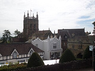
Malvern Hills is a local government district in Worcestershire, England. Its council is based in Malvern, the district's largest town. The district also includes the towns of Tenbury Wells and Upton-upon-Severn and a large rural area covering much of the western side of the county, including numerous villages. The district is named after the Malvern Hills, which are a designated Area of Outstanding Natural Beauty.

Tenbury Wells is a market town and civil parish in the northwestern extremity of the Malvern Hills District of Worcestershire, England. Its northern border adjoins Shropshire, and at the 2021 census joint with Burford it had a population of 5,224.

Abberley is a village and civil parish in north west Worcestershire, England.

Shelsley Walsh is a small village and civil parish in Worcestershire, England, on the western side of the River Teme. For administrative purposes it is presently located in the Teme Valley ward of the county’s Malvern Hills district. In the 2011 Census there was an estimated population of 28 people in 12 households. The site has been farmed since Anglo Saxon times and there are also vestiges of former industry, but it is now best known for its association with the Shelsley Walsh Speed Hill Climb.
Great Witley is a village and civil parish in the Malvern Hills District in the northwest of the county of Worcestershire, England. It is situated around ten miles to the north west of the city of Worcester. The parish had a population of 743 in 2021.

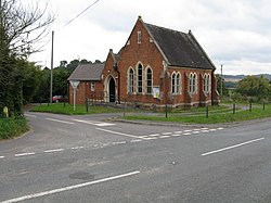
Stockton on Teme is a village and civil parish in the Malvern Hills District in the county of Worcestershire, England. It is close to the River Teme and is noted for its 12th century Norman church with an unusual circular graveyard.(photo).

Broadwas, or Broadwas-on-Teme, is a village and civil parish in the Malvern Hills district of Worcestershire, England. According to the 2021 census it had a population of 387. The village is located on the River Teme, about 6 miles west of Worcester on the A44 road.

Cotheridge is a village and civil parish in the district of Malvern Hills in the county of Worcestershire, England. It is 4 miles (6 km) west of the city of Worcester and a mile north-east of the Leigh Court railway station on the Great Western Railway on the opposite side of the River Teme.
The River Teme flows on the southern and south-western part of the village where the land is low-lying and is susceptible to flooding. The soil content is loam and clay with the subsoil being Keuper Marl.

Bransford is a village and civil parish in the Malvern Hills district of the county of Worcestershire, England. It is situated close to the River Teme and the village of Leigh. It is on the primary route between Worcester and Hereford, the A4103 that runs through the centre of the village. According to the 2021 census, Bransford has a population of 527. The parish shares its parish council with Leigh.

Clifton upon Teme is a village and civil parish in the Malvern Hills District in the county of Worcestershire, England.
The Shelsleys are a group of small villages in the Malvern Hills District in the county of Worcestershire, England. Situated on either wide of the Teme Valley near the village of Clifton-upon-Teme, they encompass the formerly distinct civil parishes of Shelsley Beauchamp, Shelsley Kings and Shelsley Walsh. The three merged in 1972 and now share a single parish council.

Rushwick is a village and civil parish in the Malvern Hills District in the county of Worcestershire, England. It is situated to the west of Worcester, Rushwick Parish comprises the four villages and hamlets of Broadmore Green, Crown East, Rushwick village and Upper Wick. The River Teme forms the southern boundary of the parish, and the Worcester to Hereford railway line passes through the village. The area of the parish is 5.0558 square kilometres (1.9521 sq mi).

Knighton on Teme is a village and civil parish once in the hundred of Doddingtree and now in the Malvern Hills District of the county of Worcestershire, England. Its name is first attested in an eleventh-century manuscript of a charter from c. 957 as Cnihtatun, meaning 'farm of the young men', and also mentions the River Teme.

Rochford consists of two hamlets, Lower and Upper Rochford. A civil parish in the Malvern Hills District near Tenbury Wells, in the county of Worcestershire, England, Rochford is 18 miles (29 km) NW of Worcester. The River Teme, which rises in Wales, flows past Lower Rochford and joins the River Severn in Worcester. The chapelry of Rochford was an exclave of Herefordshire, part of the hundred of Wolphy. It was transferred by the Counties Act 1844 to Worcestershire.

Stanford on Teme is a village and former civil parish, now in the parish of Stanford with Orleton, in the Malvern Hills district, in the county of Worcestershire, England. In 1931 the parish had a population of 144.
The Hundred of Doddingtree was granted to Ralph Todeni, or Ralph de Toni, a relative of the Duke of Normandy, in 1066 by William the Conqueror as a reward for his services as Standard bearer during the Norman Conquest. It consisted mainly of west Worcestershire.

Shelsley Beauchamp or Great Shelsley is a village and civil parish 9 miles (14 km) north west of Worcester, in the Malvern Hills district, in the county of Worcestershire, England. In 2011 the parish had a population of 192. It is on the opposite bank of the River Teme to Shelsley Walsh. The parish touches Clifton upon Teme, Great Witley, Martley, Shelsley Kings and Shelsley Walsh. It shares a parish council with Shelsley Kings and Shelsley Walsh called the Shelsley Parish Council.
Linton is a civil parish in north-east of Herefordshire, England, and is approximately 14 miles (23 km) north-east from the city and county town of Hereford. The closest town is Bromyard, conjoined to the parish at the west. The parish includes the public open land of Bringsty Common at its north-east, and the hamlet of Linley Green.