
Deerhurst is a village and civil parish in Gloucestershire, England, about 2 miles (3 km) southwest of Tewkesbury. The village is on the east bank of the River Severn. The parish includes the village of Apperley and the hamlet of Deerhurst Walton. The 2011 Census recorded the parish's population as 906, the majority of whom live in Apperley.

Earl of Coventry is a title that has been created twice in the Peerage of England. The first creation for the Villiers family was created in 1623 and took its name from the city of Coventry. It became extinct in 1687. A decade later, the second creation was for the Coventry family and is still extant.

Meriden is a village and civil parish in the Metropolitan Borough of Solihull, West Midlands, England. Historically, it is part of Warwickshire and lies between the cities of Birmingham and Coventry. It is located close to the North Warwickshire district border within a green belt of the countryside known as the Meriden Gap and is in the ecclesiastical parish of the Diocese of Coventry. The village is 6.75 miles east-northeast of Solihull, 6.5 miles west-northwest of Coventry and 4.5 miles east-southeast of Birmingham Airport. Birmingham city centre is 12.5 miles east-northeast of the village. Known as "Alspath" in the Domesday Book, it was historically thought to be the geographical centre of England until the early 2000s, though after an analysis by the Ordnance Survey this was proved to be incorrect.
Curdworth is a village and civil parish in the North Warwickshire district of the county of Warwickshire in England. The population taken at the 2011 census was 1,115.

Colonel Charles John Coventry, CB was a British Army officer and an amateur cricketer who played in two retrospectively-recognised Test matches for England in 1899. Those were his only first-class appearances and he was never a member of any first-class county team. He was born in Marylebone, Middlesex, and died in Earl's Croome, Worcestershire.

Pirton is a small village in the English county of Worcestershire. The village has been occupied since at least 1086, when Domesday listed the village of Peritone within the hundred of Pershore.

George William Coventry, 9th Earl of Coventry,, styled Viscount Deerhurst from November 1838 until 1843, was a British Conservative politician. He was Captain of the Gentlemen-at-Arms between 1877 and 1880 and again between 1885 and 1886 as well as Master of the Buckhounds between 1886 and 1892 and again between 1895 and 1901.

Wolverley is a village; with nearby Cookley, it forms a civil parish in the Wyre Forest District of Worcestershire, England. It is 2 miles north of Kidderminster and lies on the River Stour and the Staffordshire and Worcestershire Canal. At the time of the 2001 census, it had a population of 2,096.
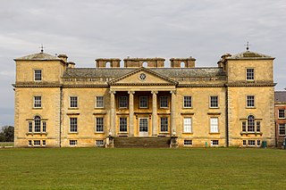
Croome Court is a mid-18th-century Neo-Palladian mansion surrounded by extensive landscaped parkland at Croome D'Abitot, near Upton-upon-Severn in south Worcestershire, England. The mansion and park were designed by Lancelot "Capability" Brown for the 6th Earl of Coventry, and they were Brown's first landscape design and first major architectural project. Some of the mansion's rooms were designed by Robert Adam. St Mary Magdalene's Church, Croome D'Abitot that sits within the grounds of the park is now owned and cared for by the Churches Conservation Trust.
Grafton Flyford is a village about 6 miles (9.7 km) east of Worcester, in Worcestershire, England.
The Croome collection – the archive of the Earls of Coventry – came into public ownership in 2005 as part of the Acceptance in Lieu of Inheritance Tax Scheme, whereby the nation accepts valuable assets to set against tax liabilities. In 2006, after making a case to the Museums, Libraries and Archives Council (MLA) for housing the collection, Worcestershire Record Office was identified as its new permanent home. A project is currently underway to catalogue the collection according to the International Standard for Archival Description (ISAD, making it fully accessible to the public for the first time.
Worcestershire Record Office is located in Worcester, England, as a part of Worcestershire County Council. The Worcestershire Record Office comprises three branches, two of which are located in County Hall, the third at The Hive, Worcester.

Hill Croome is a village, and a civil parish which covers 1000 acres, in the Malvern Hills District in the county of Worcestershire, England. Historically a parish in the lower division of the hundred of Oswaldslow, according to the 2001 census the parish had a population of 169. Hill Croome was once part of the Royal forest of Horewell.

Ripple is a village and civil parish in the county of Worcestershire, England. Ripple is one of the most southerly parishes in the county and is situated on the A38 road with the River Severn as its western boundary. Together with the villages and hamlets of Ryall, Holly Green, The Grove, Naunton, and Uckinghall, the parish has a combined population of 1,799.

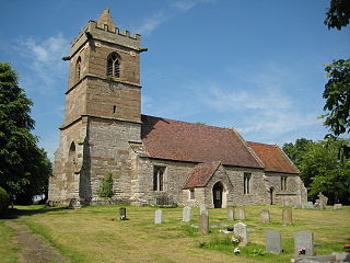
Croome D'Abitot is a village and civil parish, which shares a joint parish council with Severn Stoke, in the Malvern Hills District in the county of Worcestershire, England. The parish church of St Mary Magdalene is situated in the grounds of Croome Court.
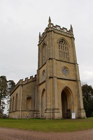
St Mary Magdalene's Church is a former Anglican church in the grounds of Croome Court, at Croome D'Abitot, Worcestershire, England. It is recorded in the National Heritage List for England as a designated Grade I listed building, and is under the care of The Churches Conservation Trust. The church, which is dedicated to Jesus' companion Mary Magdalene, stands on a hill in Croome Park. Commenting on the church, the architectural historian Nikolaus Pevsner stated it is "one of the most serious of the Early Gothic Revival outside, one of the most elegant inside".

Thomas Coventry, 2nd Baron Coventry was an English politician who sat in the House of Commons between 1625 and 1629 and was subsequently a member of the House of Lords. He supported the Royalist cause in the English Civil War.
Henry de Ardern, or Henry Ardern, was a Member of Parliament for Warwickshire in 1377 and again in 1380, and for Worcestershire from November 1381.
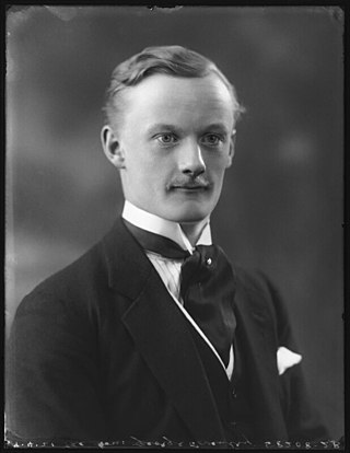
George William Reginald Victor Coventry, 10th Earl of Coventry was the son of George William Coventry, Viscount Deerhurst, and Virginia Daniel. As his father predeceased his grandfather, the 10th Earl was his grandfather's heir to the earldom. George Coventry inherited both the earldom and the viscountcy on 13 March 1930. He was educated at Ludgrove School and Eton College.

Tidmington is a village and civil parish in the Stratford-on-Avon District of Warwickshire, England. It is 11 miles (18 km) south from the town of Stratford-upon-Avon, and at the extreme southern edge of the county bordering Gloucestershire. Within the parish is the Grade II* listed c.1600 Tidmington House, and the Grade II* early 13th-century church of unknown dedication. At the 2001 Census, which for statistical purposes now includes the neighbouring parish of Burmington, the combined population was 153.

