Colwall

Last updated

Colwall
Colwall.jpg
View of Colwall Stone from the Malvern Hills
Herefordshire UK location map.svg
Red pog.svg
Colwall
Location within Herefordshire
Population2,400 (2011) [1]
OS grid reference SO756425
Civil parish
  • Colwall
Unitary authority
Ceremonial county
Region
Country England
Sovereign state United Kingdom
Post town MALVERN
Postcode district WR13
Dialling code 01684
Police West Mercia
Fire Hereford and Worcester
Ambulance West Midlands
List of places
UK
England
Herefordshire
52°04′49″N2°21′27″W / 52.08031°N 2.35746°W / 52.08031; -2.35746

Colwall is a civil parish in Herefordshire, England, situated on the border with Worcestershire, nestling on the western side of the Malvern Hills at the heart of the AONB. [2] Areas of the village are known as Colwall Stone, Upper Colwall which shares a common border at the Wyche Cutting with the Malvern suburb of Malvern Wells, and Colwall Green, spread along 2 miles (3.2 km) of the B4218 road, with the historic village core (at the parish church) being 1 mile (1.6 km) to the west of Colwall Stone.

Contents

A feature of Colwall is the view of the Iron Age British Camp (Herefordshire Beacon), which largely falls within the southeast corner of the parish. The towns of Ledbury and Malvern are 5 miles (8.0 km) southwest and 3 miles (4.8 km) northeast respectively from Colwall Stone, via the B4218. Colwall is often included in the informal region referred to as "The Malverns", which refers to the Malvern Hills and the surrounding settlements.

Amenities and landmarks

Colwall Park Hotel Colwall Park Hotel - geograph.org.uk - 1636093.jpg
Colwall Park Hotel
St. James the Great Church Colwall - St James's church - geograph.org.uk - 845504.jpg
St. James the Great Church

The village is served by a single platform railway station on the single track line between the Great Malvern and Ledbury railway stations, which passes through the Colwall Tunnels, the first of which was dug under the Malvern Hills between 1856 and 1860. The original tunnel was closed in the 1920s when it was in danger of collapse, but served the nation during the Second World War when used as a torpedo store; it is now a roost for a colony of lesser horseshoe bats. [3] Near to the station is the mock Tudor country house style Colwall Park Hotel, purpose built in 1905 to serve the now defunct Colwall Park Racecourse.

South of the village is the Grade II listed Barton Court, built circa 1785 for Henry Lambert. [4]

From the 1920s until the 1960s, the road passing through Colwall and The Wyche was numbered the A4105, before being re-classified as the B4218. It is named "Walwyn Road" from Colwall Green to The Wyche Cutting, and is served by the 675 bus route, running between Great Malvern, West Malvern and Ledbury, Mondays through Saturdays. [5]

The village has a state primary school (Church of England), and two independent preparatory schools, The Downs, Malvern College Prep. and The Elms , founded in 1614. The village is also home to a BBC Children in Need youth project 'Colwall Youth Project' [6] that serves over 180 young people from Colwall and the surrounding area (including Malvern and Ledbury). 'Colwall Youth Project' was founded by Colwall Community Church and now receives funding from National Lottery, BBC Children in Need and the Everson Trust. The world's oldest (private) miniature railway is the Downs Light Railway, located on the Downs school estate.

Colwall Stone has numerous local shops and service businesses, including a convenience store, a small fruit and vegetable shop, a butcher's shop, a pharmacy, an estate agent, a hairdressers and a specialist garden centre. There is also a library, a doctors' surgery [7] and a post office. In Upper Colwall, near The Wyche Cutting, is the Malvern Hills GeoCentre, [8] located in the Wyche Innovation Centre (occupying the former Skot Transformers building) along with a cafe and many small businesses. [9]

The village has several church buildings, most notably the historic Church of England parish church of St James the Great, [10] located in the small medieval core to the west of Colwall Stone. The 'Colwall Community Church' is situated on Walwyn Road in Colwall Stone. [11] On Jubilee Drive in Upper Colwall is the 'Wyche Free Church'. [12] There is also a large, modern village hall on Mill Lane between Colwall Stone and Colwall Green, [13] which incorporates the Church of England's St Crispin's Chapel. [10] The Church of the Good Shepherd in Upper Colwall is no longer a place of worship.

There are four public houses in the parish – the Chase Inn in Upper Colwall, the Crown in Colwall Stone, the Yew Tree in Colwall Green, and the Wellington Inn in Chance's Pitch. Additionally there is the Colwall Park Hotel and Thai Rama in Colwall Stone and the Malvern Hills Hotel at the southern end of Jubilee Drive, near the British Camp. [14]

A clock tower, built in 1931, stands in Colwall Stone, and is locally known as "Aunt Alice". [15]

The population of the parish was recorded in the 2011 census at 2,400 – compared to 2,433 in the 2001 census.

Malvern water

Malvern water has formed a part of the national heritage and culture since Queen Elizabeth I made a point of drinking it in public in the 16th century, and Queen Victoria refused to travel without it. [16] In 1987 Malvern gained recognition as a Natural Mineral Water, a mark of purity and quality. Malvern Water was the only bottled water used by Queen Elizabeth II, which she took on her travels around the world. [17]

It was mentioned in 1622 in Bannister's Breviary of the Eyes: [18]

A little more I'll of their curing tell.
How they helped sore eyes with a new found well.
Great speech of Malvern Hills was late reported
Unto which spring people in troops resorted.

..."The Malvern water says Dr John Wall is famous for containing just nothing at all"...! [19]

It was first bottled on a commercial scale in 1851 and sold as Malvern Soda and then as Malvern Seltzer Water from 1856. In 1890, Schweppes entered into a contract with a Colwall family, and built a bottling plant in 1892. The actual source of the spring is on the western side of the hills in Herefordshire. The factory was acquired by Coca-Cola & Schweppes Beverages [20] and latterly employed 25 people who bottled 12 million litres annually. On 21 October 2010, Coca-Cola announced that Malvern Water would cease production and the Colwall plant would be sold off to property developers. Malvern Water was priced out of the market, with a market share of just 1%.

Politics

Colwall has a parish council.

The parishes of Bosbury, Coddington, Colwall, and Mathon together form the ward of Hope End, which returns one elected councillor to Herefordshire Council. [21] The most recent election was in May 2015, in which the Conservative candidate, Tony Johnson, was elected. [22] Councillor Johnson is the Leader of the Council. [23]

Sport

Colwall is notable in cricket and has one of Herefordshire's main cricket groundsStowe Lane – which hosts a minor counties championship match and a minor counties knockout trophy match every year. In 1926 the Women's Cricket Association was founded in Colwall, and a Women's Cricket Week is held there every year. The Horton brothers Joseph and Henry, came from Colwall,[ citation needed ] and both played first-class cricket for Worcestershire; Henry went to greater fame with Hampshire.

Horse racing took place at Colwall Park Racecourse from 1900 to 1939, and the course also staged pony racing in 1949 and point-to-point from 1960 to 1963. [24]

Legend has it that the Colwall Stone (which gave its name to the settlement of Colwall Stone that has grown around it) was rolled down from the Malvern Hills by a giant whose footprint can be seen to this day on the slopes of the British Camp. The stone was replaced at some point; it took a horse and cart to take the old one away. [25]

Colwall also has a well known Scout group known as 1st Colwall, as well as an attached Explorer Group, named Tiggers. Tiggers recently won at Camp Cockerel, a countywide scouting competition.

Related Research Articles

<span class="mw-page-title-main">Malvern Hills</span> Hills in central England

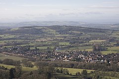
The Malvern Hills are in the English counties of Worcestershire, Herefordshire and a small area of northern Gloucestershire, dominating the surrounding countryside and the towns and villages of the district of Malvern. The highest summit affords a panorama of the Severn Valley, the hills of Herefordshire and the Welsh mountains, parts of thirteen counties, the Bristol Channel, and the cathedrals of Worcester, Gloucester and Hereford.

<span class="mw-page-title-main">Malvern, Worcestershire</span> Spa town and civil parish in Worcestershire, England

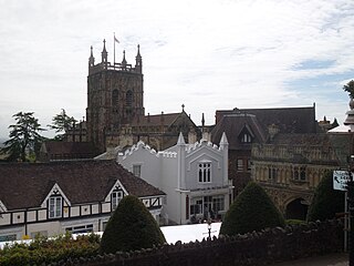
Malvern is a spa town and civil parish in Worcestershire, England. It lies at the foot of the Malvern Hills, a designated Area of Outstanding Natural Beauty. The centre of Malvern, Great Malvern, is a historic conservation area, which grew dramatically in Victorian times due to the natural mineral water springs in the vicinity, including Malvern Water.

<span class="mw-page-title-main">Malvern Hills District</span> Non-metropolitan district in England

Malvern Hills is a local government district in Worcestershire, England. Its council is based in Malvern, the district's largest town. The district also includes the towns of Tenbury Wells and Upton-upon-Severn and a large rural area covering much of the western side of the county, including numerous villages. The district is named after the Malvern Hills, which are a designated Area of Outstanding Natural Beauty.

<span class="mw-page-title-main">Schweppes</span> Soft drink brand used by companies such as Coca-Cola, Suntory, etc

Schweppes is a soft drink brand that originated in the Republic of Geneva; it is made, bottled and distributed worldwide by multiple international conglomerates, depending on licensing and region, that manufacture and sell soft drinks. Schweppes was one of the earliest forms of a soft drink, originally being regular soda water created in 1783. Today, various drinks other than soda water bear the Schweppes brand name, including various types of lemonade and ginger ales.

<span class="mw-page-title-main">Malvern Wells</span> Human settlement in England

Malvern Wells is a village and civil parish south of Great Malvern in the Malvern Hills district of Worcestershire, England. The parish, once known as South Malvern, was formed in 1894 from parts of the civil parishes of Hanley Castle, Welland, and the former parish of Great Malvern, and owes its development to the 19th-century boom years of Malvern as a spa town. Malvern Wells is a centre of commercial bottling of Malvern water. The population of the parishes of Malvern Wells and Little Malvern was recorded in 2011 as 3,196.

<span class="mw-page-title-main">Cotswold Line</span> Railway line between Oxford and Hereford

The Cotswold Line is an 86+12-mile (139.2 km) railway line between Oxford and Hereford in England.

<span class="mw-page-title-main">West Malvern</span> Human settlement in England

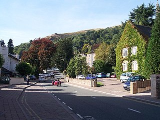
West Malvern is a village and a civil parish on the west side of the north part of the Malvern Hills, on the western edge of Worcestershire, England. It has become effectively a suburb of Malvern and part of an urban area often called The Malverns, locally administered by Malvern Hills District Council and its own parish council. Its altitude up to 250 metres gives West Malvern panoramic views of the Herefordshire countryside to the west. The Church of St James, built in 1840, has an adjacent Church of England primary school. The churchyard includes the grave of Peter Mark Roget, author of Roget's Thesaurus, who died while on holiday in the village. The 2011 Census population of 1,385 was estimated at 1,263 in 2019.

<span class="mw-page-title-main">Bosbury</span> Village in Herefordshire, England

Bosbury is a village and civil parish in Herefordshire, England, approximately 3.5 miles (5.6 km) north of Ledbury. The small River Leadon flows through the parish, passing along the west side of the village. Bosbury shares a parish council with neighbouring Coddington.

<span class="mw-page-title-main">Colwall railway station</span> Railway station in Herefordshire, England

Colwall railway station is a railway station on the Cotswold Line serving the village of Colwall in Herefordshire, England. The station has one platform with seating. There is no ticket office; a passenger-operated Permit to Travel machine is installed, and there has been a ticket machine since 2015.

<span class="mw-page-title-main">Cradley, Herefordshire</span> Human settlement in England

Cradley is a village in the civil parish of Cradley and Storridge, in Herefordshire, England. The nearest Herefordshire to Cradley towns are Ledbury, 9 miles (14 km) to the south and Bromyard, 9 miles to the north-west. The Worcestershire town of Malvern is 4 miles (6 km) to the south-east on the farther side of the Malvern Hills. Cradley and Storridge parish had a 2011 population of 1,667. On 12 October 2018 the parish was renamed from "Cradley" to "Cradley & Storridge".

<span class="mw-page-title-main">Mathon, Herefordshire</span> Human settlement in England

Mathon is a small village and civil parish in eastern Herefordshire, England, lying just to the west of the Malvern Hills between Malvern and Ledbury. Nearby villages include Cradley and Colwall. Immediately to the east is the county boundary with Worcestershire.

<span class="mw-page-title-main">Coddington, Herefordshire</span> Parish in eastern Herefordshire, England

Coddington is a hamlet and civil parish in eastern Herefordshire, England, about 3 miles (4.8 km) north of Ledbury. The west side of the parish covers part of the Malvern Hills, an official Area of Outstanding Natural Beauty. Coddington shares a parish council with neighbouring village of Bosbury.

<span class="mw-page-title-main">Malvern water</span> Natural spring water from the Malvern Hills

Malvern water is a natural spring water from the Malvern Hills on the border of the counties of Herefordshire and Worcestershire in England. The Hills consist of very hard granite and limestone rock. Fissures in the rock retain rain water, which slowly permeates through, escaping at the springs. The springs release an average of about 60 litres a minute and the flow has never been known to cease.

<span class="mw-page-title-main">Jubilee Hill</span>

Jubilee Hill is situated in the range of Malvern Hills that runs about 13 kilometres (8 mi) north-south along the Herefordshire-Worcestershire border. It lies between Perseverance Hill and Pinnacle Hill and has an elevation of 327 metres (1,073 ft).

<span class="mw-page-title-main">Wyche, Worcestershire</span> Human settlement in England

Wyche, often referred to locally as The Wyche, is a village and a suburb of the town of Malvern, Worcestershire, England, and part of the civil parish of Malvern Wells. It is situated approximately 1 mile (1.6 km) south of Great Malvern, the town's centre, on the B4218 road that runs from Malvern to Colwall.

<span class="mw-page-title-main">Malvern Water (bottled water)</span> Brand of bottled drinking water

Malvern Water is a brand of bottled drinking water obtained from a spring in the range of Malvern Hills that marks the border between the counties of Herefordshire and Worcestershire in England. The water is a natural spring water from the hills that consist of very hard granite rock. Fissures in the rock retain rain water, which slowly permeates through, escaping at the springs. The springs release an average of about 60 litres a minute. The flow rate depends on rainfall and can vary from as little as 36 litres per minute to over 350 litres per minute.

<span class="mw-page-title-main">Malvern Hills Conservators</span>

The Malvern Hills Conservators are a body corporate responsible for the care and management of the Malvern Hills and Commons. They were established in 1884 and are governed by five Acts of Parliament, the Malvern Hills Acts 1884, 1909, 1924, 1930 and 1995. They became a registered charity in 1984 and since April 2017 use the working name of the Malvern Hills Trust.

<span class="mw-page-title-main">Holy Well, Malvern</span>

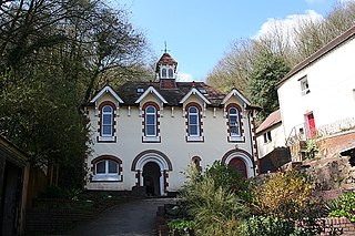
The Holy Well is set on the slopes of the Malvern Hills above Malvern Wells. The well is believed to be the site of the oldest bottling plant in the world. The Malvern spring water was first bottled on a commercial scale at the well and the building houses a modern commercial bottling plant.

<span class="mw-page-title-main">Colwall Tunnels</span> Pair of railway tunnels in England

The Colwall Tunnels are a pair of railway tunnels that connect Colwall and Malvern Wells on the Cotswold Line, passing under the Malvern Hills in the Welsh Marches region of England.

Abbey Well is a brand of bottled water produced by Coca-Cola European Partners in the United Kingdom.

References

  1. "Civil Parish population 2011". Archived from the original on 17 November 2015. Retrieved 29 October 2015.
  2. Colwall Neighbourhood Plan Colwall parish within the Malvern Hills AONB
  3. "Back Track", April 2017
  4. "Book brings historic house between Ledbury and Malvern to life". Malvern Gazette. 5 March 2021. Retrieved 21 August 2021.
  5. Astons Coaches 675 timetable
  6. "Colwall Youth Project".
  7. NHS GP: Colwall
  8. "Malvern Hills GeoCentre". www.geocentre.co.uk.
  9. Wyche Innovation Centre
  10. 1 2 "A Church Near You". Archived from the original on 1 February 2016. Retrieved 25 January 2016.
  11. "Colwall Community Church - Relaxed and Informal, but Serious about God". Colwall Community Church.
  12. Wyche Free Church
  13. "Colwall Village Hall". Colwall Village Hall.
  14. "UK Pub Guide, Campaign for Real Ale • whatpub.com". whatpub.com.
  15. "Search page". buildingstones.org.uk. Retrieved 2 April 2024.
  16. Hansard HC Deb 15 February 1983 vol 37 cc268-74
  17. http://malvern.whub.org.uk/home/mhcindex/mhc-businit/mhc-businit-exper0ience/mhc-businit-cocacola.htm%5B%5D Malvern Hills District Council. Retrieved 20 May 200
  18. F. N. L. Poynter: Notes on a late Sixteenth-Century Ophthalmic Work
  19. Dr John Wall (1756): Experiments & Observations on the Malvern Waters
  20. CocaCola Malvern water web page. Retrieved 20 May 2009 Archived 24 May 2009 at the Wayback Machine
  21. LGBCE Archived 15 February 2016 at the Wayback Machine Final recommendations 2014 review - PDF map
  22. Herefordshire Council Hope End declaration 2015
  23. Herefordshire Council Cllr A W Johnson
  24. Pitt, Chris (2006). A Long Time Gone (Rev. and updated ed.). Halifax: Portway. pp. 204–207. ISBN   1901570622.
  25. Ash, Russell (1973). Folklore, Myths and Legends of Britain. Reader's Digest Association Limited. p. 313. ISBN   9780340165973.