Lexington, consolidated with Fayette County and often denoted as Lexington-Fayette, is the second-largest city in Kentucky and the 60th-largest city in the United States. By land area, Lexington is the 28th largest city in the United States. Known as the "Horse Capital of the World," it is the heart of the state's Bluegrass region. It has a nonpartisan mayor-council form of government, with 12 council districts and three members elected at large, with the highest vote-getter designated vice mayor. In the 2017 U.S. Census Estimate, the city's population was 321,959, anchoring a metropolitan area of 512,650 people and a combined statistical area of 856,849 people.

Scouting in Kentucky has a long history, from the 1910s to the present day, serving thousands of youth in programs that suit the environment in which they live. Kentucky has a very early Scouting heritage, as the home state of Daniel Carter Beard.

The Daniel Boone National Forest is a national forest in Kentucky. Established in 1937, it includes 708,000 acres (287,000 ha) of federally owned land within a 2,100,000 acres (850,000 ha) proclamation bounty. The name of the forest was changed in 1966 in honor of the explorer Daniel Boone.

The Okefenokee Swamp is a shallow, 438,000-acre (177,000 ha), peat-filled wetland straddling the Georgia–Florida line in the United States. A majority of the swamp is protected by the Okefenokee National Wildlife Refuge and the Okefenokee Wilderness. The Okefenokee Swamp is considered to be one of the Seven Natural Wonders of Georgia. The Okefenokee is the largest "blackwater" swamp in North America.

The Cumberland Gap National Historical Park is a United States National Historical Park located at the border between Kentucky, Tennessee, and Virginia, centered on the Cumberland Gap, a natural break in the Appalachian Mountains.
Buckhorn Lake, located south of Buckhorn, Kentucky, United States and northwest of Hazard, Kentucky off Kentucky Route 28, is a 1,230-acre (5 km2) reservoir created by the United States Army Corps of Engineers in 1967 by impounding the Kentucky River.
The University of Kentucky Research and Education Center Botanical Garden, also known as the UK REC Botanical Garden, is a research farm and botanical garden for the University of Kentucky in Princeton, Kentucky.

Kentucky Lake is a major navigable reservoir along the Tennessee River in Kentucky and Tennessee. Created in 1944 by the Tennessee Valley Authority's impounding of the Tennessee River by Kentucky Dam, the 160,309-acre (649 km2) lake is the largest artificial lake by surface area in the United States east of the Mississippi River, with 2,064 miles of shoreline, although the nearby Lake Barkley is larger by volume. Kentucky Lake has a flood storage capacity of 4,008,000 acre-feet, more than 2.5 times of the next largest lake in the TVA system.
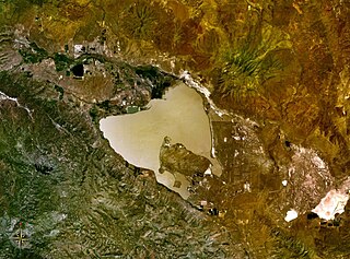
Honey Lake is an endorheic sink in the Honey Lake Valley in northeastern California, near the Nevada border. Summer evaporation reduces the lake to a lower level of 12 square kilometers and creates an alkali flat.

The Zachary Taylor House, also known as Springfield, was the boyhood home of the twelfth President of the United States, Zachary Taylor. Located in Louisville, Kentucky, Taylor lived there from 1795 to 1808, held his marriage there in 1810, and returned there periodically the rest of his life.

Bad Branch Falls State Nature Preserve is a 2,639-acre (10.68 km2) nature preserve in Letcher County, Kentucky. Originally dedicated by the Office of Kentucky Nature Preserves on September 26, 1985, the preserve originally covered 435 acres (1.76 km2) and included Bad Branch Gorge, a forested gorge with a 60-foot (18 m) waterfall tumbling over sandstone cliffs on the south face of Pine Mountain. Subsequent acquisitions have expanded the preserve west into the Presley House Branch watershed, northeast into the upper reaches of the Bad Branch watershed and a small portion of the north face of Pine Mountain. The preserve also protects Kentucky's only known nesting pair of common ravens. Bad Branch has been designated a Kentucky Wild River. There are 7.4 miles (11.9 km) of foot trails and bridges over uneven strenuous terrain.

Riverside, The Farnsley–Moremen Landing is a historic 300-acre (120 ha) farm and house in south end Louisville, Kentucky, along the banks of the Ohio River. The house, a red brick I-house with a two-story Greek Revival portico, was built c. 1838 by Gabriel Farnsley.

Reeds Gap State Park is a 220 acres (89 ha) Pennsylvania state park in Armagh Township, Mifflin County, Pennsylvania in the United States. The park is largely a wilderness area with large white pine and hemlock trees. Honey Creek flows through the park, providing a habitat for trout. Reeds Gap State Park is 7 miles (11 km) from U.S. Route 322 near Milroy in New Lancaster Valley and Bald Eagle State Forest.

Lake Barkley State Resort Park is a park on the eastern shore of Lake Barkley just west of Cadiz, Kentucky in Trigg County. The park encompasses 3,700 acres (1,500 ha) and is one of three Kentucky parks on Land Between the Lakes, a 170,000-acre (69,000 ha) isthmus between Kentucky Lake and Lake Barkley.
Paintsville Lake State Park is a park located just west of Paintsville, Kentucky in Johnson County. The park itself encompasses 242 acres (98 ha), while Paintsville Lake, its major feature, covers approximately 1,139 acres (461 ha) extending into parts of Morgan County.

Pennyrile Forest State Resort Park is a park located near Dawson Springs, Kentucky in Hopkins County. The park encompasses 863 acres (349 ha) and takes its name from a colloquial form of the word pennyroyal, a small flowering plant native to the area. Park features include a 24-room lodge with restaurant, 12 cottages, campground, multi-purpose trails, 18-hole golf course, and 56-acre (23 ha) lake with non-motorized boat rentals.
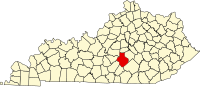
Brigadoon State Nature Preserve is a state nature preserve located in Barren County, Kentucky adjacent to Barren River Lake.

Carr Creek State Park is a park located along Kentucky Route 15 in Knott County, Kentucky, United States. The park itself encompasses 29 acres (12 ha), while the park's main feature, Carr Creek Lake, covers 750 acres (300 ha).
Honey Grove, sometimes spelled as Honeygrove, is an unincorporated community in Christian County, Kentucky, United States. Kentucky Route 508 runs through the community. Honey Grove has a single firehouse that is staffed by volunteer personnel.
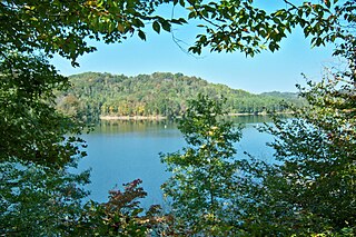
Honey Creek State Park is located in Appanoose County, Iowa. The state park has a hunting unit, a resort, and a fish hatchery.