Fiordland National Park is a national park in the south-west corner of South Island of New Zealand. It is the largest of the 13 national parks in New Zealand, with an area covering 12,607 km2 (4,868 sq mi), and a major part of the Te Wāhipounamu a UNESCO World Heritage Site established in 1990. The park is administered by the Department of Conservation. The southern ranges of the Southern Alps cover most of Fiordland National Park, combined with the deep glacier-carved valleys.

Arthur's Pass National Park is located in the South Island of New Zealand and covers 1,185 km2 of mostly mountainous terrain. Adjacent to it lies Craigieburn Forest Park. The park is administered by the Department of Conservation.
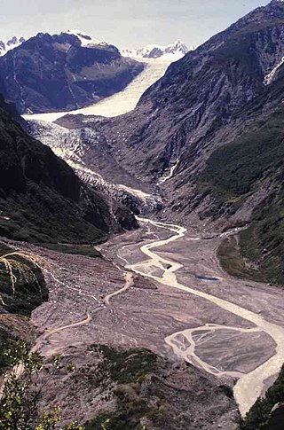
Fox Glacier is a 13-kilometre-long (8.1 mi) temperate maritime glacier located in Westland Tai Poutini National Park on the West Coast of New Zealand's South Island. Like nearby Franz Josef Glacier, Fox Glacier is one of the most accessible glaciers in the world, with a terminal face as low as 300 m above sea level, close to the village of Fox Glacier. It is a major tourist attraction and about 1000 people daily visit it during high tourist season.
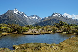
The Routeburn Track is a world-renowned, 32 km tramping (hiking) track found in the South Island of New Zealand. The track can be done in either direction, starting on the Queenstown side of the Southern Alps, at the northern end of Lake Wakatipu or on the Te Anau side, at the Divide, several kilometres from the Homer Tunnel to Milford Sound.
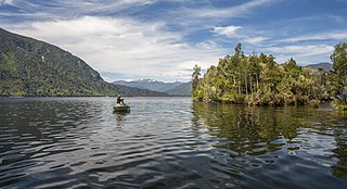
Lake Brunner is the largest lake in the West Coast Region of New Zealand, located 31 km (19 mi) southeast of Greymouth. The main settlement, Moana, is on its northern shore. It is an important settlement and waystation for local Māori. The first Europeans in the area were loggers, and sawmills were an important early industry. Being several kilometres inland from the coast road, it is less frequently visited by tourists than many of the West Coast's scenic highlights, but it is becoming increasingly popular, in part due to its reputation for fishing.

Mount Pirongia is an extinct stratovolcano located in the Waikato region of New Zealand's North Island. It rises to 959 m (3,146 ft) and is the highest peak around the Waikato plains. Pirongia's many peaks are basaltic cones created by successive volcanic eruptions between the late Pliocene and early Pleistocene, about 2.5 million years ago. In the adjacent picture, the characteristic profile of the mountain can be seen, along with a prominent accessory cone to the right.

The Tararua Range, often referred to as the Tararua Ranges or Tararua, is one of several mountain ranges in the North Island of New Zealand.

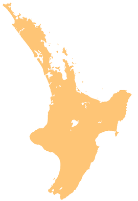
The North Island Volcanic Plateau is a volcanic plateau covering much of central North Island of New Zealand with volcanoes, lava plateaus, and crater lakes. It contains the Taupō caldera complex, Ōkataina caldera complex and Tongariro Volcanic Centre resulting in it being currently the most frequently active and productive area of silicic volcanism on Earth. New Zealand is part of the Pacific Ring of Fire.

The Rossendale Valley is in the Rossendale area of Lancashire, England, between the West Pennine Moors and the main range of the Pennines. The area includes the steep-sided valleys of the River Irwell and its tributaries, which flow southwards into Greater Manchester. The rivers cut through the moorland of the Rossendale Hills, generally characterized by open unwooded land, despite the ancient designation of "forest".

White Deer Hole Creek is a 20.5-mile (33.0 km) tributary of the West Branch Susquehanna River in Clinton, Lycoming and Union counties in the U.S. state of Pennsylvania. A part of the Chesapeake Bay drainage basin, the White Deer Hole Creek watershed drains parts of ten townships. The creek flows east in a valley of the Ridge-and-valley Appalachians, through sandstone, limestone, and shale from the Ordovician, Silurian, and Devonian periods.
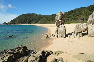
The Abel Tasman Coast Track is a 60 kilometres (37 mi) long walking track within the Abel Tasman National Park in New Zealand. It extends from Mārahau in the south to Wainui in the north, with many side tracks. It is one of two main tracks through the park, the other being the Abel Tasman Inland Track, which stretches for 38 km between Tinline Bay and Torrent Bay off the main coastal track. The coastal track is well sheltered, and with mild weather in all seasons, it is accessible and open throughout the year.

Craigieburn Forest Park is a protected area in the South Island of New Zealand, adjacent to Arthur's Pass National Park to the north.

The Waiheke River is a river of the West Coast Region of New Zealand's South Island. It flows west from its origins on Mount Barron in the Southern Alps to reach the Ahaura River, which it forms where it joins the Tūtaekurī River, 20 kilometres northwest of Lake Sumner.
Hunting is a popular recreational pursuit and a tourist activity in New Zealand with numerous books and magazines published on the topic. Unlike most other developed countries with a hunting tradition, there are no bag-limits or seasons for hunting large game in New Zealand. Hunting in national parks is a permitted activity. The wide variety of game animals and the limited restrictions means hunting is a popular pastime which has resulted in a high level of firearms ownership among civilians.
The Trexler Nature Preserve is an 1,108-acre county park (448 ha) owned and maintained by Lehigh County in the Lehigh Valley region of Pennsylvania. The preserve is situated in Lowhill Township and North Whitehall Township and the land that comprises the preserve was originally purchased between 1901 and 1911 by local industrialist General Harry Clay Trexler.

The Paparoa Track is a 55.7 km (34.6 mi) shared hiking and mountain biking track located in Paparoa National Park in the South Island of New Zealand. The track was created as a memorial for the 29 miners who lost their lives in the Pike River Mine disaster. The track is the tenth Great Walk to be created and has been fully open since 1 March 2020. It was the first addition to the Great Walks in 25 years.

Hutt Water Collection Area is a reserve located in Upper Hutt in the Wellington Region at the southern end of New Zealand's North Island. It is administered by Wellington Regional Council and is located alongside the larger Kaitoke Regional Park.

The Copland Track is a tramping track in the south Westland area of New Zealand's South Island, well known for the naturally-occurring hot springs at Welcome Flat along its route. The main track is approximately 25 kilometres (16 mi) long one-way from the trailhead at State Highway 6 to the track's inland end at the Douglas Rock Hut, and is usually completed in 2 to 4 days depending on whether the full distance is walked, with many opting to walk only as far as Welcome Flat. The track is the western portion of a longer path which historically connected the West Coast to Mount Cook Village via Copland Pass, however erosion and the retreat of the Hooker Glacier has led to the eastern side of this route becoming increasingly dangerous to traverse.

The historic Haast to Paringa Cattle Track is a trail through South Westland, New Zealand, constructed in 1875 to allow farmers in the Landsborough and Cascade Valley area to drive their cattle on an annual two-week journey to the sale yards in Whataroa. It was constructed as an inland loop to bypass the precipitous cliffs at Knights Point. For 90 years it was the only land access to the settlements of Haast and Jackson Bay, but the last mob of cattle was driven in 1961, and the construction of a highway connecting Paringa to Haast Pass in 1965 made it redundant. After falling into disuse, the cattle track was converted into a 33-kilometre (21 mi), three-day tramping track, opening in 1981. The track and its three huts are maintained by the New Zealand Department of Conservation.
The Tūtaekurī River starts near the Hope Pass, in the Southern Alps and flows north-west to join the Ahaura River. The Ahaura joins the Grey River which flows to the Tasman Sea at Greymouth. Tūtaekurī River has been its official name since 21 June 2019. Tūtae kurī is a grass with the latin name agropyron multiflorum.