
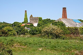
Mount Wellington Tin mine, two miles east of the village of St Day in Cornwall, in the United Kingdom, opened in 1976 and was the first new mine in the region in many years.

Geevor Tin Mine, formerly North Levant Mine is a tin mine in the far west of Cornwall, United Kingdom, between the villages of Pendeen and Trewellard. It was operational between 1911 and 1990 during which time it produced about 50,000 tons of black tin. It is now a museum and heritage centre left as a living history of a working tin mine. The museum is an Anchor Point of ERIH, The European Route of Industrial Heritage. Since 2006, the mine has been part of the UNESCO World Heritage Site Cornwall and West Devon Mining Landscape.

Mullion is a civil parish and village on the Lizard Peninsula in south Cornwall, England, United Kingdom. The nearest town is Helston approximately 5 miles (8 km) to the north.

Gwennap is a village and civil parish in Cornwall, England, United Kingdom. It is about five miles (8 km) south-east of Redruth.

Crowan is a village and civil parish in Cornwall, United Kingdom. It is about three-and-a-half miles (6 km) south of Camborne. A former mining parish, all of the mines had shut by 1880.

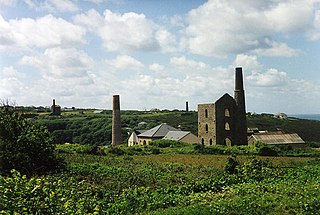
Wheal Jane is a disused tin mine near Baldhu and Chacewater in West Cornwall, England, United Kingdom. The area itself consisted of a large number of mines.

Belowda is a village in Cornwall, England, UK. The village is just north of the A30 trunk road, about seven miles west-southwest of Bodmin. The village also gives its name to the nearby Belowda Beacon. It is in the civil parish of Roche.
Banns is a hamlet in west Cornwall, England, United Kingdom situated between Mount Hawke and Porthtowan at grid reference SW 710 480 in the civil parish of St Agnes. The South West Coast Path is 2 km (1.2 mi) to the west of the hamlet.

The Great County Adit, sometimes called the County Adit, or the Great Adit was a system of interconnected adits that helped drain water from the tin and copper mines in the Gwennap area of Cornwall, in the United Kingdom. Construction started in 1748 and it eventually reached a length of over 40 miles (64 km) of a tunnel, providing drainage to over 100 mines at an average depth of 80–100 metres (260–330 ft).

Wheal Peevor was a metalliferous mine located on North Downs about 1.5 miles north-east of Redruth, Cornwall, England. The first mining sett was granted here in around 1701 on land owned by the St Aubyn family. It was originally mined at shallow depths for copper, but when the price for that metal slumped after 1788, the mine was able to change to mining tin ore, which was found deeper down. In the late 18th century Wheal Peevor had the advantage of being drained by the Great County Adit which was around 100 metres deep here. The mine covered only 12 acres but had rich tin lodes. In addition to tin and copper, pyrite was also mined here between 1872 and 1887.
Wheal Busy, sometimes called Great Wheal Busy and in its early years known as Chacewater Mine, was a metalliferous mine halfway between Redruth and Truro in the Gwennap mining area of Cornwall, England. During the 18th century the mine produced enormous amounts of copper ore and was very wealthy, but from the later 19th century onwards was not profitable. Today the site of the mine is part of the Cornwall and West Devon Mining Landscape World Heritage Site.

Consolidated Mines, also known as Great Consolidated mine, but most commonly called Consols or Great Consols was a metalliferous mine about a mile ESE of the village of St Day, Cornwall, England. Mainly active during the first half of the 19th century, its mining sett was about 600 yards north–south; and 2,700 yards east–west, to the east of Carharrack. Although always much troubled by underground water, the mine was at times highly profitable, and it was the largest single producer of copper ore in Cornwall. Today the mine is part of the Cornwall and West Devon Mining Landscape World Heritage Site.

Trencrom Hill is a prominent hill fort, owned by the National Trust, near Lelant, Cornwall. It is crowned by an univallate Neolithic tor enclosure and was re-used as a hillfort in the Iron Age. Cairns or hut circles can be seen in the level area enclosed by the stone and earth banks. The hill overlooks the Hayle Estuary and river, and Mount's Bay and St. Michael's Mount can be seen to the south. The hill was recorded as Torcrobm in 1758 which is derived from Cornish "torr crobm", i.e. 'hunched bulge'.
Pennance is a hamlet near Lanner in west Cornwall, England.
Rinsey is a hamlet in Cornwall, England, United Kingdom. It is located off the main A394 road between Helston and Penzance in the civil parish of Breage. The nearby hamlet of Rinsey Croft is located 1 km to the north-east. The nearby cliffs and beach are owned and managed by the National Trust and part of Rinsey East Cliff is designated as the Porthcew Site of Special Scientific Interest (SSSI) for its geological interest. The South West Coast Path passes through the property. Rinsey lies within the Cornwall Area of Outstanding Natural Beauty (AONB).
Wheal Baddon is a hamlet south of Baldhu in the county of Cornwall, in the United Kingdom.
Wheal Kitty is a village in Cornwall, England, United Kingdom. It is located about half a mile north east of St Agnes on the Goonlaze Downs plateau. It contains the headquarters of Surfers Against Sewage.

Wheal Fortune or Great Wheal Fortune is the site of a mine in the civil parishes of Breage and Sithney in west Cornwall. Part of the disused mine was designated as a Site of Special Scientific Interest (SSSI) for its geological interest in 1991 and is also a Geological Conservation Review site of national importance for the minerals on the site.
The Portreath Tramroad, or alternatively the Portreath Tramway was opened in 1815, providing a wagonway route from mines near Scorrier in Cornwall, England, to a port at Portreath. From there, it could be transported to market by coastal shipping. It was later extended to serve the Poldice mine near St Day, and became known as the Poldice Tramroad, or Poldice Tramway.

Basset Mines was a mining company formed in Cornwall, England, by the amalgamation of six copper and tin mining setts. It operated from 1896 until 1918, when it was closed due to a fall in the price of tin.
