
Bourke Street is one of the main streets in the Melbourne central business district and a core feature of the Hoddle Grid. It was traditionally the entertainment hub of inner-city Melbourne, and is now also a popular tourist destination and tram thoroughfare.

Queen Victoria Village, generally known as QV Melbourne or just QV, is a precinct in the Melbourne central business district, Victoria, Australia. Covering the city block bounded by Lonsdale, Little Lonsdale, Swanston, and Russell Streets, and located directly opposite the State Library of Victoria and Melbourne Central, QV comprises a large shopping centre, a central plaza, an underground food court, Melbourne central city's first full-size supermarket and apartment buildings.

Collins Street is a major street in the central business district of Melbourne, Victoria, Australia. It was laid out in the first survey of Melbourne, the original 1837 Hoddle Grid, and soon became the most desired address in the city. Collins Street was named after Lieutenant-Governor of Tasmania David Collins who led a group of settlers in establishing a short-lived settlement at Sorrento in 1803.

La Trobe Street is a major street and thoroughfare in the city centre of Melbourne, Victoria, Australia. It runs roughly east–west and forms the northern boundary of Melbourne's central business district. The street was laid out as an extension of the original Hoddle Grid in 1839 and was named after Charles La Trobe. La Trobe Street extends from Victoria Street in the east to Harbour Esplanade in the west.

Hardware Lane is a wide laneway in Melbourne, Australia. It runs roughly north–south between Bourke Street and Little Lonsdale Street in the city centre. It changes name to Hardware Street between Lonsdale and Little Lonsdale Streets.

The City Square was a public plaza located in the Central Business District (CBD) of Melbourne, Victoria, Australia. The site is currently bounded by Swanston Street, Collins Street, Flinders Lane and the Westin Hotel. The historic landmarks of Melbourne Town Hall and St Paul’s Cathedral are across the streets to the north and south respectively. The square has been redeveloped several times and associated with a number of controversies over the years.

Centre Place is a laneway and pedestrian precinct in Melbourne, Australia. It runs north from Flinders Lane to Collins Street, between Elizabeth Street and Swanston Street.

Little Collins Street is a minor street in the central business district (CBD) of Melbourne, Victoria, Australia.

Degraves Street is a pedestrian precinct and thoroughfare in Melbourne, Victoria, Australia. It is a short, narrow laneway in the Central Business District that runs north–south from Flinders Street to Flinders Lane and is situated in-between Swanston Street and Elizabeth Street. Degraves, as the street is colloquially known, is famous for its alfresco dining options and because it epitomises Melbourne's coffee culture and street art scene. For these reasons it has also become a popular tourist destination.
The Royal Arcade is a historic shopping arcade in the central business district of Melbourne, Victoria, Australia. Opened in 1870, it connects Bourke Street Mall to Little Collins Street, with a side offshoot to Elizabeth Street. It is the oldest surviving arcade in Australia, known for its elegant light-filled interior, and the large carved mythic figures of Gog and Magog flanking the southern entry.

McKillop Street is a street in Melbourne, Victoria. It is a short, quiet and narrow open laneway, running between Bourke Street and Little Collins Street between Queen Street and Elizabeth Street in the central business district of Melbourne.

Block Place is a street in Melbourne. It is a short, narrow partially covered laneway, running south from Little Collins Street between Swanston Street and Elizabeth Street in the central business district of Melbourne.

Flinders Lane is a minor street and thoroughfare in the central business district of Melbourne, Victoria, Australia. The laneway runs east–west from Spring Street to Spencer Street in-between Flinders and Collins Streets. Originally laid out as part of the Hoddle Grid in 1837, the laneway was once the centre of Melbourne's rag trade and is still home to boutique designers and high-end retailers including Chanel, now perched alongside numerous upscale hotels like the W Hotel Melbourne and Adelphi Hotel, loft apartments, cafes and bars.
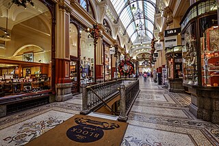
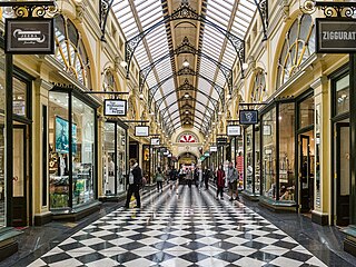
The Block Arcade is an historic shopping arcade in the central business district of Melbourne, Victoria, Australia. Constructed between 1891 and 1893, it is considered one of the late Victorian era's finest shopping arcades and ranks among Melbourne's most popular tourist attractions.

Cathedral Arcade is a heritage shopping arcade in Melbourne, Victoria.
Marcus Barlow (1890–1954) was a prominent Australian architect in the interwar period, who designed a number of notable central city buildings in his home-town of Melbourne. He is best known for the 1932 Manchester Unity Building, whose Gothic corner spire dominates the major intersection of the city.

The Melbourne central business district in Australia is home to numerous lanes and arcades. Often called "laneways", these narrow streets and pedestrian paths date mostly from the Victorian era, and are a popular cultural attraction for their cafes, bars and street art.

Port Phillip Arcade was a small arcade in Melbourne, the capital city of the Australian state of Victoria with several cafés and general food outlets. It connects Flinders Lane with Flinders Street between Swanston Street and Degraves Street.

St. Collins Lane is a shopping centre completed in 2016, designed by ARM Architecture, which stretches between Collins and Little Collins streets in Melbourne, Australia. Previously there were restaurants, arcades and hotels on the site.
Melbourne, the capital of Victoria, Australia, was an important Victorian-era city and erected "some of the world's most majestic buildings" of the era. Several buildings survive from the period, including the State Library of Victoria (1856), Parliament House (1856), the General Post Office, the Royal Exhibition Building (1880), the Windsor Hotel (1884), the Block Arcade (1893), and the Rialto Building Group (1888–1891). However, many of the well-known architectural gems of Melbourne's Victorian central city were demolished in the 20th-century. Some were lost in preparation for the 1956 Summer Olympics when Melbourne sought to reinvent itself as a modern, post-war city. Whelan's or Whelan the Wrecker was a well-known demolition company that was responsible for at least thirty of these demolitions, many at the instruction of the Melbourne City Council.
