Related Research Articles

The Cascade Range or Cascades is a major mountain range of western North America, extending from southern British Columbia through Washington and Oregon to Northern California. It includes both non-volcanic mountains, such as many of those in the North Cascades, and the notable volcanoes known as the High Cascades. The small part of the range in British Columbia is referred to as the Canadian Cascades or, locally, as the Cascade Mountains. The highest peak in the range is Mount Rainier in Washington at 14,411 feet (4,392 m).

The Okanagan, also called the Okanagan Valley and sometimes the Okanagan Country, is a region in the Canadian province of British Columbia defined by the basin of Okanagan Lake and the Canadian portion of the Okanagan River. It is part of the Okanagan Country, extending into the United States as Okanogan County in north-central Washington. According to the 2016 Canadian census, the region's population is 362,258. The largest populated cities are Kelowna, Penticton, Vernon, and West Kelowna.
Highway 97 is a major highway in the Canadian province of British Columbia. It is the longest continuously numbered route in the province, running 2,081 km (1,293 mi) and is the only route that runs the entire north–south length of British Columbia, connecting the Canada–United States border near Osoyoos in the south to the British Columbia–Yukon boundary in the north at Watson Lake, Yukon.

Hope is a district municipality at the confluence of the Fraser and Coquihalla rivers in the province of British Columbia, Canada. Hope is at the eastern end of both the Fraser Valley and the Lower Mainland region, and is at the southern end of the Fraser Canyon. To the east, over the Cascade Mountains, is the Interior region, beginning with the Similkameen Country on the farther side of the Allison Pass in Manning Park. Located 154 kilometres (96 mi) east of Vancouver, Hope is at the southern terminus of the Coquihalla Highway and the western terminus of the Crowsnest Highway, locally known as the Hope-Princeton, where they merge with the Trans-Canada Highway. Hope is at the eastern terminus of Highway 7. As it lies at the eastern end of the Fraser Valley in the windward Cascade foothills, the town gets very high amounts of rain and cloud cover – particularly throughout the autumn and winter.
New Caledonia was a fur-trading district of the Hudson's Bay Company that comprised the territory of the north-central portions of present-day British Columbia, Canada. Though not a British colony, New Caledonia was part of the British claim to North America. Its administrative centre was Fort St. James. The rest of what is now mainland British Columbia was called the Columbia Department by the British, and the Oregon Country by the Americans. Even before the partition of the Columbia Department by the Oregon Treaty in 1846, New Caledonia was often used to describe anywhere on the mainland not in the Columbia Department, such as Fort Langley in the Fraser Valley.
Spuzzum is an unincorporated community in the lower Fraser Canyon area of southwestern British Columbia, Canada. The place is on the west shore of the Fraser River and north shore of Spuzzum Creek. The locality, on BC Highway 1, is by road about 40 kilometres (25 mi) north of Hope and 69 kilometres (43 mi) south of Lytton.
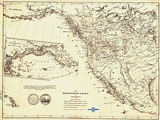
British Columbia gold rushes were important episodes in the history and settlement of European, Canadian and Chinese peoples in western Canada.

The Cariboo Road was a project initiated in 1860 by the Governor of the Colony of British Columbia, James Douglas. It was built in response to the Cariboo Gold Rush to facilitate settlement of the area by miners. It involved a feat of engineering stretching from Fort Yale to Barkerville, B.C. through extremely hazardous canyon territory in the Interior of British Columbia.

Alexander Caulfield Anderson was a British Hudson's Bay Company (HBC) fur-trader, explorer of British Columbia and civil servant.

The Fraser Canyon Gold Rush, began in 1858 after gold was discovered on the Thompson River in British Columbia at its confluence with the Nicoamen River a few miles upstream from the Thompson's confluence with the Fraser River at present-day Lytton. The rush overtook the region around the discovery and was centered on the Fraser Canyon from around Hope and Yale to Pavilion and Fountain, just north of Lillooet.

The Columbia District was a fur trading district in the Pacific Northwest region of British North America in the 19th century. Much of its territory overlapped with the disputed Oregon Country. It was explored by the North West Company between 1793 and 1811, and established as an operating fur district around 1810. The North West Company was absorbed into the Hudson's Bay Company in 1821 under which the Columbia District became known as the Columbia Department. The Oregon Treaty of 1846 marked the effective end of the Hudson's Bay Company's Columbia Department.

The Whatcom Trail was an overland trail from the Puget Sound area of Washington Territory during the Fraser Canyon Gold Rush of 1858. The trail began on Bellingham Bay, at Fairhaven, the route used went via a route known as the Columbia Valley, which is a lowland route connecting the mid-Nooksack River area with Cultus Lake and the lower Chilliwack River in the Upper Fraser Valley, about 80 km east of today's Vancouver. In 1858, T. G. Richards built the first brick building in Washington as an outfitter for those using the Whatcom Trail.

The Douglas Road, a.k.a. the Lillooet Trail, Harrison Trail or Lakes Route, was a goldrush-era transportation route from the British Columbia Coast to the Interior. Over 30,000 men are reckoned to have travelled the route in, although by the end of the 1860s it was virtually abandoned due to the construction of the Cariboo Wagon Road, which bypassed the region.

The Okanagan Trail was an inland route to the Fraser Canyon Gold Rush from the Lower Columbia region of the Washington and Oregon Territories in 1858–1859. The route was essentially the same as that used by the Hudson's Bay Company fur brigades, following the Columbia River to the confluence of the Okanogan River, and then up that river's watercourse via Osoyoos, Skaha (Dog) and Okanagan lakes, then using a pass via Monte Creek to Fort Kamloops, at the confluence of the North and South Thompson rivers. From there, the route went west down the Thompson River either to the lower gold-bearing bars of the Fraser River between what is now Lytton, British Columbia and Yale, British Columbia, or via Hat Creek and Marble Canyon to the upper Fraser goldfields around present-day Lillooet, British Columbia. A shorter branch-route to the lower Thompson and lower Fraser Canyon diverged from the main route at the confluence of the Similkameen River and the Okanogan. Cayoosh and The Fountains are today's Lillooet, British Columbia and environs.
The Dewdney Trail is a 720 km (450 mi) trail in British Columbia, Canada, that served as a major thoroughfare in mid-19th century British Columbia. The trail was a critical factor in the development and strengthening of the newly established British colony of British Columbia, tying together mining camps and small towns that were springing up during the gold rush era prior to the colony's joining Canada in 1871. Establishing this route became important and urgent for the colony when many new gold finds occurred at locations near the US border that at the time were much more easily accessed from Washington Territory than from the then barely settled parts of the Lower Mainland and Cariboo. Approximately 80 percent of the trail's route has been incorporated into the Crowsnest Highway.
Nicola, also Nkwala or N'kwala, was an important First Nations political figure in the fur trade era of the British Columbia Interior as well as into the colonial period (1858–1871). He was grand chief of the Okanagan people and chief of the Nicola Valley peoples, an alliance of Nlaka'pamux and Okanagans and the surviving Nicola Athapaskans, and also of the Kamloops Band of the Shuswap people.

The British Columbia Interior, popularly referred to as the BC Interior or simply the Interior, is a geographic region of the Canadian province of British Columbia. While the exact boundaries are variously defined, the British Columbia Interior is generally defined to include the 14 regional districts that do not have coastline along the Pacific Ocean or Salish Sea, and are not part of the Lower Mainland. Other boundaries may exclude parts of or even entire regional districts, or expand the definition to include the regional districts of Fraser Valley, Squamish–Lillooet, and Kitimat–Stikine.
The Old Cariboo Road is a reference to the original wagon road to the Cariboo gold fields in what is now the Canadian province of British Columbia. It should not be confused with the Cariboo Road, which was built slightly later and used a different route.

Thompson Country, also referred to as The Thompson and sometimes as the Thompson Valley and historically known as the Couteau Country or Couteau District, is a historic geographic region of the Southern Interior of British Columbia, more or less defined by the basin of the Thompson River. This is a tributary of the Fraser; the major city in the area is Kamloops.
References
- ↑ ""First Brigade Trail", Outdoor Recreation Guide, fvrd.ca" (PDF). Archived from the original (PDF) on 2016-03-04. Retrieved 2014-11-24.
- ↑ ""1858 Gold Rush Trail", Outdoor Recreation Guide, fvrd.ca" (PDF). Archived from the original (PDF) on 2016-03-04. Retrieved 2014-11-24.
- ↑ "HBC Heritage Trail | Hope Mountain Centre". Hope Mountain Centre for Outdoor Learning. Retrieved 2023-04-27.
- ↑ "Tikwalus Heritage Trail | Hope Mountain Centre". Hope Mountain Centre for Outdoor Learning. Retrieved 2023-04-27.
- Gibson, James R. (1997). The Lifeline of the Oregon Country: The Fraser-Columbia Brigade System, 1811-47 . University of British Columbia (UBC) Press. ISBN 0-7748-0643-5.