
The Ball Range is a mountain range on the Continental Divide between Vermilion Pass and Red Earth Pass in Kootenay National Park, Canada. The range is named after John Ball, a politician who helped secure funding for the Palliser expedition.

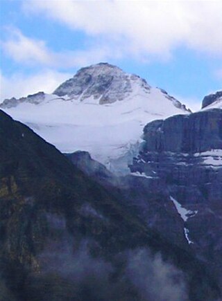
Mount Ball is a mountain located on the Continental Divide, on the borders of Banff and Kootenay national parks in Western Canada. Mt. Ball is the highest peak of the Ball Range in the Canadian Rockies.
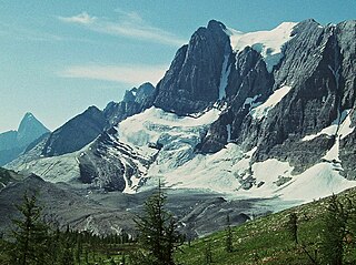
Stanley Peak is a 3,155-metre (10,351 ft) mountain located in the Ball Range, at the northeastern section of Kootenay National Park, in the Canadian Rocky Mountains. The mountain was named in 1901 by its first climber, the English explorer Edward Whymper, after Frederick Stanley, 16th Earl of Derby, the sixth Governor-General of Canada. There are sources that date the naming in 1912 after Stanley H. Mitchell, Secretary-Treasurer of Alpine Club of Canada.

The Purcell Mountains are a mountain range in southeastern British Columbia, Canada. They are a subrange of the Columbia Mountains, which includes the Selkirk, Monashee, and Cariboo Mountains. They are located on the west side of the Rocky Mountain Trench in the area of the Columbia Valley, and on the east side of the valley of Kootenay Lake and the Duncan River. The only large settlements in the mountains are the Panorama Ski Resort and Kicking Horse Resort, adjacent to the Columbia Valley towns of Invermere and Golden, though there are small settlements, such as Yahk and Moyie along the Crowsnest Highway, and residential rural areas dependent on the cities of Creston, Kimberley and Cranbrook, which are located adjacent to the range..

The Purcell Wilderness Conservancy is a provincial park in British Columbia, Canada. It was established in 1974, and encompasses six large drainages in the Purcell Mountains in the southeast of the province. It contains high peaks, alpine meadows and ridges, deep creek and river valleys, and hot springs at Dewar Creek.

Mount Goodsir is the highest mountain in the Ottertail Range, a subrange of the Park Ranges in British Columbia. It is located in Yoho National Park, near its border with Kootenay National Park. The mountain has two major summits, the South Tower and the North Tower, 3,525 metres (11,565 ft).

The Kootenay Ranges, also known as the Western Ranges, are one of the three main subdivisions of the Continental Ranges which comprise the southern half of the Canadian Rockies, the other two subdivisions being the Front Ranges and the Park Ranges. The Kootenay Ranges lie between the Bull River (E) and the town of Golden, British Columbia (W) and south of Kicking Horse Pass, and are the location of the headwaters of the Kootenay River
Mount Little is situated at the northern end of Kootenay National Park, and straddles the Continental Divide marking the Alberta-British Columbia border. It was named in 1916 after George F. Little, a member of the first ascent party.
A mountain formerly known as Mount Pétain, but with no current official name, is located on the border of the Canadian provinces of Alberta and British Columbia (BC) on the Continental Divide.
The Nelson Range is a subrange of the Selkirk Mountains in the West Kootenay region of British Columbia, Canada. It is located south of the west arm of Kootenay Lake between the Salmo (W) and Kootenay Rivers (E) and also to the west of the south arm of Kootenay Lake. The range gets its name from the City of Nelson, which is on the south bank of the West Arm of Kootenay Lake and at the foot of the range's northwestern slopes.
The Kokanee Range is a subrange of the Selkirk Mountains in the West Kootenay region of southeastern British Columbia, Canada. It is located between the valley of the Slocan River (W) and that of Kootenay Lake (E), and to the north of the Kootenay River and the West Arm of Kootenay Lake. The range includes Kokanee Glacier Provincial Park, Kokanee Peak, and Grays Peak, notable as the mountain featured on the label of Kokanee beer. The name "Kokanee" refers to a land-locked variety of Sockeye salmon.
Mount Fisher, also known locally as Fisher Peak, is a 2,843-metre (9,327-foot) mountain summit located in the Hughes Range of the Canadian Rockies in British Columbia, Canada. Situated east of historic Fort Steele and the Rocky Mountain Trench, this prominent peak is visible from the Crowsnest Highway and Cranbrook. Its nearest higher peak is Mount Morro, 23.0 km (14.3 mi) to the north. The Steeples are located 10.0 km (6.2 mi) to the south.

The Steeples is a 2,843-metre (9,327-foot) elevation mountain ridge located at the southern end of the Hughes Range in the Canadian Rockies of British Columbia, Canada. Situated immediately east of Norbury Lake Provincial Park and the Rocky Mountain Trench, this prominent five kilometres in length ridge is visible from the Crowsnest Highway and Cranbrook. The nearest higher peak is Mount Fisher, 10.0 km (6.2 mi) to the north-northwest.

Foster Peak is a 3,204-metre (10,512-foot) mountain summit located on the western border of Kootenay National Park. It is the highest point in the Vermilion Range, a sub-range of the Canadian Rockies of British Columbia, Canada. Its nearest higher peak is Mount Ball, 14.96 km (9.30 mi) to the northeast. The mountain is part of what is known as The Rockwall. Floe Lake, southeast of the peak, is one of the beauty spots of Kootenay National Park. The area is accessible via the Floe Lake Trail and Rockwall Trail. The Rockwall Trail is a scenic 55 kilometre traverse of alpine passes, subalpine meadows, hanging glaciers, and limestone cliffs, in some places in excess of 900 metres above the trail.

Mount Drysdale is a 2,932-metre (9,619-foot) mountain summit located on the western border of Kootenay National Park in the Vermilion Range, which is a sub-range of the Canadian Rockies of British Columbia, Canada. Its nearest higher peak is Rockwall Peak, 1.0 km (0.62 mi) to the west. The mountain is part of what is known as the Rockwall which is an escarpment of the Vermilion Range. The Rockwall Trail is a scenic 55 kilometre traverse of alpine passes, subalpine meadows, hanging glaciers, and limestone cliffs, in some places in excess of 900 m (2,950 ft) above the trail.

Mount Gray is a 2,886-metre (9,469-foot) mountain summit located on the western border of Kootenay National Park in the Vermilion Range, which is a sub-range of the Canadian Rockies in British Columbia, Canada. Its nearest higher peak is Tumbling Peak, 3.1 km (1.9 mi) to the southeast. The mountain is part of what is known as the Rockwall which is an escarpment of the Vermilion Range. The Rockwall Trail is a scenic 55 kilometre traverse of alpine passes, subalpine meadows, hanging glaciers, and limestone cliffs, in some places in excess of 900 m (2,953 ft) above the trail.
Tumbling Peak is a 3,145-metre (10,318-foot) mountain summit located on the western border of Kootenay National Park in the Vermilion Range, which is a sub-range of the Canadian Rockies of British Columbia, Canada. The mountain takes its name from the Tumbling Glacier located on its northeast flank. Its nearest higher peak is Foster Peak, 6.8 km (4.2 mi) to the southeast. Hewitt Peak is also to the southeast, and Mount Gray is to the immediate northwest. The mountain is situated in an area known as the Rockwall, which is an escarpment of the Vermilion Range. The Rockwall Trail is a scenic 55 kilometers traverse of alpine passes, sub-alpine meadows, hanging glaciers, and limestone cliffs, in some places in excess of 900 meters above the trail.

Mount Harkin is a 2,979-metre (9,774-foot) mountain summit located in the Kootenay River Valley along the eastern border of Kootenay National Park. Park visitors can see the peak from Highway 93, also known as the Banff–Windermere Highway. It is part of the Mitchell Range, which is a sub-range of the Canadian Rockies of British Columbia, Canada. Its nearest higher peak is Mount Assiniboine, 14.0 km (8.7 mi) to the northeast.
Mount Selkirk is a 2,930-metre (9,610-foot) mountain summit located in the Vermilion River Valley along the eastern border of Kootenay National Park. Park visitors can see the peak from Highway 93, also known as the Banff–Windermere Highway. It is part of the Mitchell Range, which is a sub-range of the Canadian Rockies of British Columbia, Canada. The nearest higher neighbor is Catlin Peak, 1.6 km (0.99 mi) to the northwest.
The Vermilion Range is a mountain range of the Canadian Rockies, in British Columbia, Canada. The range is west of the Vermilion River and east of the headwaters of the Kootenay River.

