
Celestún is a town in Yucatán, Mexico. It is located in the northwest corner of the state, just north of the border with the state of Campeche, on the Gulf of Mexico coast at 20°51.5′N90°24′W. In 2000, it had a population of just under 6,000 people; however, the population swells to 10,000 during the octopus hunting season. It is mostly a fishing town, with a 19th-century lighthouse and an abandoned historic hacienda. Besides fishing, Celestún also produces salt, as it has done from pre-Columbian times. Tourism is also making up an increasing portion of the town's economy, as the community has many kilometers of sand beaches and abundant wildlife.
Cajeme is one of the 72 municipalities of the northwestern state of Sonora, Mexico. It is named after Cajemé, a Yaqui leader. The municipality has an area of 3,312.05 km2 and with a population of 436,484 inhabitants as of 2020.

Heroica Nogales, more commonly known as Nogales, is a city and the county seat of the Municipality of Nogales. It is located on the northern border of the Mexican state of Sonora. The city is abutted on its north by the city of Nogales, Arizona, across the U.S.-Mexico border.

Benito Juárez, is a borough in Mexico City. It is a largely residential area, located to the south of historic center of Mexico City, although there are pressures for areas to convert to commercial use. It was named after Benito Juárez, president in the 19th century.
Huatabampo is a city in Huatabampo Municipality in the state of Sonora, in northwestern Mexico. It is situated on the Gulf of California, near the mouth of the Mayo River. It is located at latitude 26°49′N109°40′W. Huatabampo is 34 km (21 mi) southwest of Navojoa via Sonora State Highway 56 and Sonora State Highway 149. Mexican Federal Highway 15 can be accessed via Sonora State Highway 176. It is notable as the home of revolutionary general Álvaro Obregón, a successful chickpea farmer before the Mexican Revolution, and now his burial site.
Navojoa is the fifth-largest city in the northern Mexican state of Sonora and is situated in the southern part of the state. The city is the administrative seat of Navojoa Municipality, located in the Mayo River Valley.
Mexico City is one of the 32 federal entities of Mexico, the others being the 31 states. It was named Distrito Federal up to February 5, 2016, when it was officially renamed the Ciudad de México. According to the 2020 Mexican Census, it is the second most populated entity with 9,209,944 inhabitants and the smallest by land area spanning 1,494.3 square kilometres (577.0 sq mi).

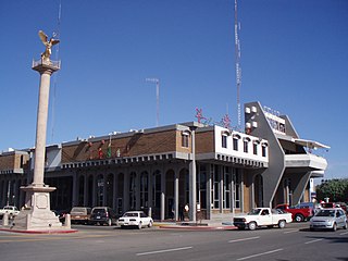
Ciudad Obregón is a city in southern Sonora. It is the state's second largest city after Hermosillo and serves as the municipal seat of Cajeme, as of 2020, the city has a population of 436,484. Ciudad Obregón is 530 km (330 mi) south of the state's northern border.

Cócorit is a town located in the municipality of Cajeme in the southern part of the Mexican state of Sonora. The name of the town is derived from the Yaqui word for a chili pepper, ko'oko'i. Cócorit and the municipality of Cajeme are within the Yaqui River Valley. The comisario municipal of Cajeme is Ing. Arturo Soto Valenzuela. Cócorit reported a 2005 census population of 7,953 inhabitants, and is the fifth-largest town in the municipality of Cajeme.

Federal Highway 1 is a free (libre) part of the federal highway corridors of Mexico, and the highway follows the length of the Baja California Peninsula from Tijuana, Baja California, in the north to Cabo San Lucas, Baja California Sur, in the south. The road connects with Via Rapida, which merges into the American Interstate 5 (I-5) at the San Ysidro Port of Entry, which crosses the international border south of San Ysidro, California.

Mexicali Municipality is a municipality in the Mexican state of Baja California. Its municipal seat is located in the city of Mexicali. As of 2020, the municipality had a total population of 1,049,792. The municipality has an area of 13,700 km2 (5,300 sq mi). This includes many smaller outlying communities as well as the city of Mexicali. Also, the islands of Baja California located in the Gulf of California are part of the municipality, among them the mudflat islands at the mouth of the Colorado River, Isla Ángel de la Guarda and the islands of the San Lorenzo Marine Archipelago National Park. Mexicali is the northernmost municipality of Latin America.

Colonia Roma, also called La Roma or simply, Roma, is a district located in the Cuauhtémoc borough of Mexico City just west of the city's historic center, and in fact is no longer a single colonia (neighbourhood) but now two officially defined ones, Roma Norte and Roma Sur, divided by Coahuila street.

The Roman Catholic Diocese of Ciudad Obregón. It is centered in Ciudad Obregón, Sonora, Mexico. It is a suffragan diocese of the Archdiocese of Hermosillo. Along with the Archdiocese of Chihuahua and the Diocese of Ciudad Juárez, it yielded territory in 1966 to form the Territorial Prelature of Madera.

Ciudad Benito Juárez, or simply Juárez, is the name of a city located in the eastern part of the Monterrey metropolitan area in the state of Nuevo León, Mexico. It is the seat of the municipality of the same name. Ciudad Benito Juárez had a 2010 census population of 256,970 persons and is the eighth-largest city in Nuevo León. It shares borders with the municipalities of Pesquería to the north; to the south with Santiago; to the east with Cadereyta Jiménez; and to the west with Guadalupe.
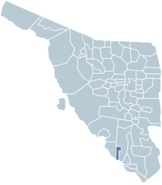
Bácum Municipality is a municipality of southwestern Sonora, in northwestern Mexico. The population was 21,322 in 2005.

The Benito Juárez National Park is in the Valles Centrales Region of Oaxaca, Mexico, and includes parts of the municipalities of San Felipe Tejalapam and San Andres Huayapan. The southern boundary of the park is about 5 kilometers north of the City of Oaxaca. The park was established in 1937 during the presidency of General Lazaro Cardenas del Rio, and is named after President Benito Juárez, who was a native of Oaxaca.
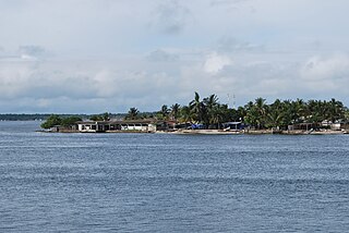
Sánchez Magallanes is a small fishing town and port located in the far northwest of the state of Tabasco, Mexico in the municipality of Cárdenas. It is named after a leader in the French Intervention in Mexico, Coronel Andrés Sánchez Magallanes. The town is located on small peninsula which is between the Gulf of Mexico and a lagoon called Del Carmen, which the port faces. Fishing is the main economic activity here, especially the production of oysters, although there is tourism and oil production as well. The last has been problematic for fishing and tourism due to pollution. The most serious environmental problem is the erosion of the area’s fragile beaches, especially the thin strips of land between the Gulf and the lagoons.

Tekax Municipality is one of the 106 municipalities in the Mexican state of Yucatán containing (3,819.61 km2) of land and is located roughly 125 kilometres (78 mi) southeast of the city of Mérida.

San Pedro de los Pinos is a neighborhood located in center-west of Mexico City. Before being urbanized during the first half of the 20th century, the colonia was part of a vast farming area belonging to several ranches and haciendas.

Colonia Florida is a neighborhood in Mexico City, located in the Álvaro Obregón borough.