
Kingston upon Hull, usually abbreviated to Hull, is a port city and unitary authority area in the East Riding of Yorkshire, England. It lies upon the River Hull at its confluence with the Humber Estuary, 25 miles (40 km) inland from the North Sea and 37 miles (60 km) south-east of York, the historic county town. With a population of 267,014 (2021), it is the fourth-largest city in the Yorkshire and the Humber region after Leeds, Sheffield and Bradford.

A lightvessel, or lightship, is a ship that acts as a lighthouse. They are used in waters that are too deep or otherwise unsuitable for lighthouse construction. Although some records exist of fire beacons being placed on ships in Roman times, the first modern lightvessel was off the Nore sandbank at the mouth of the River Thames in England, placed there by its inventor Robert Hamblin in 1734. The type has become largely obsolete; lighthouses replaced some stations as the construction techniques for lighthouses advanced, while large, automated buoys replaced others.

The River Ancholme is a river in Lincolnshire, England, and a tributary of the Humber. It rises at Ancholme Head, a spring just north of the village of Ingham and immediately west of the Roman Road, Ermine Street. It flows east and then north to Bishopbridge west of Market Rasen, where it is joined by the Rase. North of there it flows through the market town of Brigg before draining into the Humber at South Ferriby. It drains a large part of northern Lincolnshire between the Trent and the North Sea.

The Bridgwater and Taunton Canal is a canal in the south-west of England between Bridgwater and Taunton, opened in 1827 and linking the River Tone to the River Parrett. There were a number of abortive schemes to link the Bristol Channel to the English Channel by waterway in the 18th and early 19th centuries. These schemes followed the approximate route eventually taken by the Bridgwater and Taunton Canal, but the canal was instead built as part of a plan to link Bristol to Taunton by waterway.
The River Hull is a navigable river in the East Riding of Yorkshire in Northern England. It rises from a series of springs to the west of Driffield, and enters the Humber Estuary at Kingston upon Hull. Following a period when the Archbishops of York charged tolls for its use, it became a free navigation. The upper reaches became part of the Driffield Navigation from 1770, after which they were again subject to tolls, and the section within the city of Hull came under the jurisdiction of the Port of Hull, with the same result.

The A63 is a major road in Yorkshire, England between Leeds and Kingston upon Hull. A section between North Cave and Hull forms the eastward continuation of the M62 motorway and is part of the unsigned Euroroute E20.

Bristol Harbour is the harbour in the city of Bristol, England. The harbour covers an area of 70 acres. It is the former natural tidal river Avon through the city but was made into its current form in 1809 when the tide was prevented from going out permanently. A tidal by-pass was dug for 2 miles through the fields of Bedminster for the river, known as the "River Avon New Cut", "New Cut", or simply "The Cut". It is often called the Floating Harbour as the water level remains constant and it is not affected by the state of the tide on the river in the Avon Gorge, The New Cut or the natural river southeast of Temple Meads to its source.

The Leven Canal runs for 3.18 miles (5.1 km) from the River Hull to the village of Leven, East Riding of Yorkshire, England. It was built for Mrs Charlotta Bethell in 1805, and remained in use until 1935. It is now a Site of Special Scientific Interest.

The Spurn Lightship is a lightvessel, previously anchored in Hull Marina in the British city of Kingston upon Hull, England. It was relocated to a shipyard in October 2021 for restoration, prior to becoming a display together with the Arctic Corsair.

The Stainforth and Keadby Canal is a navigable canal in South Yorkshire and Lincolnshire, England. It connects the River Don Navigation at Bramwith to the River Trent at Keadby, by way of Stainforth, Thorne and Ealand, near Crowle. It opened in 1802, passed into the control of the River Don Navigation in 1849, and within a year was controlled by the first of several railway companies. It became part of the Sheffield and South Yorkshire Navigation, an attempt to remove several canals from railway control, in 1895. There were plans to upgrade it to take larger barges and to improve the port facilities at Keadby, but the completion of the New Junction Canal in 1905 made this unnecessary, as Goole could easily be reached and was already a thriving port.

The Hull and Selby Railway is a railway line between Kingston upon Hull and Selby in the United Kingdom which was authorised by an act of 1836 and opened in 1840. As built the line connected with the Leeds and Selby Railway at Selby, with a Hull terminus adjacent to the Humber Dock.

Netham Lock is the point at Netham in Bristol at which boats from the River Avon, acting as part of the Kennet and Avon Canal, gain access to Bristol's Floating Harbour.

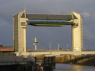
The Port of Hull is a port at the confluence of the River Hull and the Humber Estuary in Kingston upon Hull, in the East Riding of Yorkshire, England.

The Hull Maritime Museum is a museum in Kingston upon Hull, England, that explores the seafaring heritage of the city and its environs. The museum's stated mission is "To preserve and make available the maritime history of Hull and east Yorkshire through artefacts and documents".

The Port of Grimsby is located on the south bank of the Humber Estuary at Grimsby in North East Lincolnshire. Sea trade out of Grimsby dates to at least the medieval period. The Grimsby Haven Company began dock development in the late 1700s, and the port was further developed from the 1840s onwards by the Manchester, Sheffield and Lincolnshire Railway (MSLR) and its successors. The port has had three main dock systems:

The Port of Immingham, also known as Immingham Dock, is a major port on the east coast of England, located on the south bank of the Humber Estuary in the town of Immingham, Lincolnshire. In 2019, the Port of Grimsby & Immingham was the largest port in the United Kingdom by tonnage with 54.1 million tonnes of cargo passing through that year.

The Canal & River Trust (CRT), branded as Glandŵr Cymru in Wales, holds the guardianship of 2,000 miles of canals and rivers, together with reservoirs and a wide range of heritage buildings and structures, in England and Wales. Launched on 12 July 2012, the Trust took over the responsibilities of the state-owned British Waterways in those two places.
The following is a timeline of the history of the city of Kingston upon Hull, East Riding of Yorkshire, England.
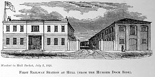
Manor House Street station was the original terminus station of the Hull and Selby Railway, opened in 1840 adjacent to the Humber Dock in Kingston upon Hull, England. In 1848 the station was superseded by Hull Paragon station after which it was primarily used for goods traffic.

Hedon Haven is a waterway that connected the Humber Estuary with the port of Hedon, in Holderness, East Riding of Yorkshire, England. The waterway allowed ships to unload at the port in Hedon, which was also known as Hedon Haven and had, at its peak, three canalised arms that stretched into the town. The port at Hedon was the main port for south Holderness between the 12th and 13th centuries, and was the busiest port in Holderness before the docks at Hull were built.
