Hundred of Blackheath, Surrey

Last updated

Coordinates: 51°12′22″N0°31′23″W / 51.206°N 0.523°W / 51.206; -0.523 Blackheath Hundred or the Hundred of Blackheath was a hundred in the county of Surrey, England. It corresponds to parts of the districts of Waverley and Guildford.

Geographic coordinate system Coordinate system

A geographic coordinate system is a coordinate system that enables every location on Earth to be specified by a set of numbers, letters or symbols. The coordinates are often chosen such that one of the numbers represents a vertical position and two or three of the numbers represent a horizontal position; alternatively, a geographic position may be expressed in a combined three-dimensional Cartesian vector. A common choice of coordinates is latitude, longitude and elevation. To specify a location on a plane requires a map projection.

Surrey County of England

Surrey is a subdivision of the English region of South East England in the United Kingdom. A historic and ceremonial county, Surrey is also one of the home counties. The county borders Kent to the east, East Sussex and West Sussex to the south, Hampshire to the west, Berkshire to the northwest, and Greater London to the northeast.

Contents

Use and significance

Though used for entirely secular purposes, it consisted of eleven parishes which in the polity of England from the Norman Conquest until the late 19th century had dual secular and religious functions. Its economic unity was shattered like most hundreds given the rise of smaller manors and newer manors which came to form the main, manageable agricultural asset throughout the country. It occupied approximately the south to south-west twelfth of the county. [1] [2]

Manor an estate in land to which is incident the right to hold a manorial court

A manor in English law is an estate in land to which is incident the right to hold a court termed court baron, that is to say a manorial court. The proper unit of tenure under the feudal system is the fee, on which the manor became established through the process of time, akin to the modern establishment of a "business" upon a freehold site. The manor is nevertheless often described as the basic feudal unit of tenure and is historically connected with the territorial divisions of the march, county, hundred, parish and township.

Its parishes were [1] [2]

Albury, Surrey village and civil parish in the borough of Guildford in Surrey, England

Albury is a village and civil parish in the borough of Guildford in Surrey, England, about 4 miles (6.4 km) south-east of Guildford town centre. The village is within Surrey Hills Area of Outstanding Natural Beauty and part of it forms the 63 acres (0.25 km2) Colyer's Hanger SSSI, financially supported by Natural England. Farley Green, Little London and adjacent Brook form part of the secular parish.

Alfold a village located in Waverley, United Kingdom

Alfold is a village and civil parish in Surrey, England on the West Sussex border. Alfold is a dispersed or polyfocal village in the Green Belt, which is buffered from all other settlements. The Greensand Way runs north of the village along the Greensand Ridge and two named localities exist to the north and south of the historic village centre which features pubs, a set of stocks and a whipping post.

Bramley, Surrey farm village in the United Kingdom

Bramley is a village and civil parish about three miles (5 km) south of Guildford in the Borough of Waverley in Surrey, south east England. Most of the parish lies in the Surrey Hills Area of Outstanding Natural Beauty.

History

The hundred court meeting place was on the River Wey at a place called Perry Bridge, or La Perie at the western edge of Shalford. The jurisdiction of the sheriff's court was much curtailed by private rights. In 1086 Odo, Earl of Kent (and Bishop of Bayeux) held Bramley, its central area. The Victoria County History attributes its conflation with Bramley to its stated size of 6½ hides of land, versus 97 stated to exist before the Norman Conquest in the same 'Domesday Book' survey document. The manorial lords of Bramley, Shalford, Wintershull, and Gomshall, and the rectors of Shalford and Cranleigh also had courts leet, and the lord of Albury view of frankpledge, but the latter gave those profits to the Crown. The lord of Shere claimed view of frankpledge up to 1238, the lord of Albury claimed the same, and it was granted to Bramley by charter of Henry III. These townships paid an annual fine to the sheriff. In 1671 Shere paid the most, at 20s. The royal rights, such as they were, were granted by James VI and I in 1620 to Sir Edward Zouche of Woking Palace, and to the heirs male of Sir Alan his uncle, together with the very large manor of Woking (the main asset), Woking Hundred and other lands, to be held by the service of bringing in the first dish to the king's table on St. James's Day and paying annually £100 (initially equivalent to £19,133in 2016 but reduced in modern terms by inflation). All feudal system incidents were expressly abrogated at that time. Eventually the hundred rent ceased to be reclaimable from any tenants in the area.

River Wey river in Surrey, United Kingdom

The River Wey is a tributary of the River Thames in south east England and one of two major tributaries in Surrey. The name is of unknown origin and meaning. It begins as two branches rising outside the county which join at Tilford between Guildford and Farnham. Once combined the flow is eastwards then northwards via Godalming and Guildford to meet the Thames while in Surrey. The main sub-tributary is the Tillingbourne flowing from the western slopes of Leith Hill in Surrey westwards to a point just south of Guildford between the main village of Shalford and the hamlet of Peasmarsh. Downstream the river forms the backdrop to Newark Priory and Brooklands.

Victoria County History

The Victoria History of the Counties of England, commonly known as the Victoria County History or the VCH, is an English history project which began in 1899 and was dedicated to Queen Victoria with the aim of creating an encyclopaedic history of each of the historic counties of England. In 2012 the project was rededicated to Queen Elizabeth II in celebration of her Diamond Jubilee year. Since 1933 the project has been coordinated by the Institute of Historical Research in the University of London.

The hide was an English unit of land measurement originally intended to represent the amount of land sufficient to support a household. It was traditionally taken to be 120 acres, but was in fact a measure of value and tax assessment, including obligations for food-rent, maintenance and repair of bridges and fortifications, manpower for the army, and (eventually) the geld land tax. The hide's method of calculation is now obscure: different properties with the same hidage could vary greatly in extent even in the same county. Following the Norman Conquest of England, the hidage assessments were recorded in the Domesday Book and there was a tendency for land producing £1 of income per year to be assessed at 1 hide. The Norman kings continued to use the unit for their tax assessments until the end of the 12th century.

Charles II granted the £100 rent and the reversion for 1,000 years legally to Viscount Grandison, Henry Howard, and Edward Villiers, in reality in trust for the first's daughter, his most favoured mistress, who he later created Duchess of Cleveland.

Charles II of England King of England, Ireland and Scotland

Charles II was king of England, Scotland and Ireland. He was king of Scotland from 1649 until his deposition in 1651, and king of England, Scotland and Ireland from the restoration of the monarchy in 1660 until his death.

Viscount Grandison title in the Peerage of Ireland

Viscount Grandison, of Limerick, is a title in the Peerage of Ireland. It was created in 1620 for Sir Oliver St John, the Lord Deputy of Ireland. He was the descendant and namesake of Oliver St John, whose elder brother Sir John St John was the ancestor of the Barons St John of Bletso and the Earls of Bolingbroke. Moreover, St John's nephew Sir John St John, 1st Baronet, of Lydiard Tregoze, was the ancestor of the Viscounts Bolingbroke and the Viscounts St John.

Barbara Palmer, 1st Duchess of Cleveland English royal mistress from the Villiers family

Barbara Palmer, 1st Duchess of Cleveland, more often known by her maiden name Barbara Villiers or her title of Countess of Castlemaine, was an English royal mistress of the Villiers family and perhaps the most notorious of the many mistresses of King Charles II of England, by whom she had five children, all of them acknowledged and subsequently ennobled. Her influence was so great that she has been referred to as "The Uncrowned Queen". Barbara was the subject of many portraits, in particular by court painter Sir Peter Lely. Her extravagance, bad temper, adultery with the king, and influence at court provoked the diarist John Evelyn to describe her as the "curse of the nation", whereas Samuel Pepys often wrote admiringly of seeing her. In the Gilded Age, it was stylish to adorn an estate with her likeness.

In 1708 James Zouche, younger son of Sir Edward, the last of the male heirs, died. The Duchess of Cleveland succeeded, but died on 9 October 1709. Her trustees in 1715 sold the rights, as well as in Woking, to John Walter of Busbridge House, Godalming, whose son sold them to Lord Onslow in 1752. [2] The dwindling value hundreds later came to possess was lost outright by a process of population expansion and industrialisation, with rights and land ownership becoming bound up with the smaller estates within them in the 19th century.

Richard Onslow, 3rd Baron Onslow British politician and peer, died 1776

Richard Onslow, 3rd Baron Onslow KB was a British peer and politician, styled Hon. Richard Onslow from 1717 to 1740.

Related Research Articles

Cranleigh village in Surrey County, England

Cranleigh is a large village and civil parish, self-proclaimed the largest in England, about 8 miles (13 km) southeast of Guildford in Surrey. It lies east of the A281, which links Guildford with Horsham, on an alternative route that is not an A-road. It is in the north-west corner of the Weald, a large remnant forest, the main local remnant being Winterfold Forest directly north-west on the northern Greensand Ridge.

Borough of Guildford Borough and Non-metropolitan district in England

The Borough of Guildford is a local government district with borough status in Surrey, England. With around half of the borough's population, Guildford is its largest settlement and only town, and is the location of the council.

Frankpledge was a system of joint suretyship common in England throughout the Early Middle Ages, and High Middle Ages. The essential characteristic was the compulsory sharing of responsibility among persons connected in tithings. This unit, under a leader known as the chief-pledge or tithing-man, was then responsible for producing any man of that tithing suspected of a crime. If the man did not appear, the entire group could be fined.

The court leet was a historical court baron of England and Wales and Ireland that exercised the "view of frankpledge" and its attendant police jurisdiction, which was normally restricted to the hundred courts.

Guildford (UK Parliament constituency) Parliamentary constituency in the United Kingdom

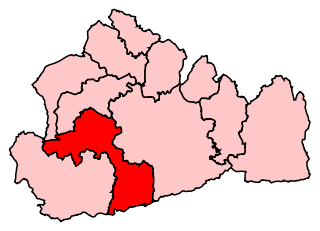
Guildford is a constituency in Surrey represented in the House of Commons of the UK Parliament since 2005 by Anne Milton, a Conservative.

Shere village in Surrey, England

Shere is a village in the Guildford district of Surrey, England 4.8 miles (7.7 km) east south-east of Guildford and 5.4 miles (8.7 km) west of Dorking, centrally bypassed by the A25. It is a small still partly agricultural village chiefly set in the wooded 'Vale of Holmesdale' between the North Downs and Greensand Ridge with many traditional English features. It has a central cluster of old village houses, shops including a blacksmith and trekking shop, tea house, art gallery, two pubs and a Norman church. Shere has a CofE infant and nursery school with 'outstanding academic results' catering for 2- to 7-year-old children which serves the village and surrounding villages and towns, and a museum which opens most afternoons at weekends.

Chilworth, Surrey village in United Kingdom

Chilworth is a village in the Guildford borough of Surrey, England, southeast of Guildford. Chilworth has three churches, two pre-secondary education schools, an independent pub-restaurant and a railway station. The village occupies both sides of the Tillingbourne between outcrops of the Greensand Ridge including St Martha's Hill. Footpaths lead through fields and woodlands along the ranges of hills. Chilworth is split between two civil parishes, Shalford CP to the west and St Martha's CP to the east. It also has a recreation ground with a park that has a sports pavilion used for football, and an all weather table tennis table.

Wonersh farm village in the United Kingdom

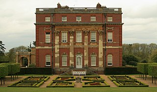
Wonersh is a village and civil parish in the Waverley district of Surrey, England and Surrey Hills Area of Outstanding Natural Beauty. Wonersh contains three Conservation Areas and spans an area three to six miles SSE of Guildford. In the outer London commuter belt, the village is 28 miles (45 km) southwest of London. Wonersh's economy is predominantly a service sector economy. Three architecturally-listed churches are within its boundaries as are a number of notable homes such as Frank Cook's 1905 hilltop mansion, which is a hotel, business and wedding venue.

The list of known High Sheriffs of Surrey extends back to 1066. At various times the High Sheriff of Surrey was also High Sheriff of Sussex.

Hundred of Elmbridge

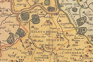
The Hundred of Elmbridge or Elmbridge/Emley Hundred was a geographic subdivision in the north of the county of Surrey, England. The majority of its area forms the borough of Elmbridge in Surrey, with the remainder forming part of the Royal Borough of Kingston upon Thames in Greater London.

The Hundred of Wotton, Wotton Hundred or Dorking Hundred was a hundred in Surrey, England.

St Peters Church, Old Woking Church in Woking, England

St Peter's Church is situated in Old Woking, Surrey, England. It is recorded in the Domesday Book. It also has the third oldest surviving door in the British Isles. It also has the oldest door in Surrey.

Sir Edward Braye was an English Royal Navy captain, justice of the peace, high sheriff and MP.

References

  1. 1 2 Youngs, Frederic (1979). Guide to the Local Administrative Units of England. I: Southern England. London: Royal Historical Society. ISBN   0901050679.
  2. 1 2 3 H.E. Malden (editor) (1911). "The hundred of Blackheath: Introduction and map". A History of the County of Surrey: Volume 3. Institute of Historical Research. Retrieved 30 January 2014.