
Cranham is a residential area of east London, and part of the London Borough of Havering. It is located 17.5 miles (28 km) east-northeast of Charing Cross and comprises an extensive built-up area to the north and a low density conservation area to the south surrounded by open land. It was historically a rural village in the county of Essex and formed an ancient parish. It is peripheral to London, forming the eastern edge of the urban sprawl. The economic history of Cranham is characterised by a shift from agriculture to housing development. As part of the suburban growth of London in the 20th century, Cranham significantly increased in population, becoming part of Hornchurch Urban District in 1934 and has formed part of Greater London since 1965. The 2011 Census population of Cranham was included in Upminster.

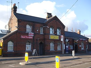
Upminster is a suburban town in East London, England, within the London Borough of Havering. Located 16.5 miles (26.6 km) east-northeast of Charing Cross, it is one of the locally important district centres identified in the London Plan.

The London Borough of Havering in East London, England, forms part of Outer London. It has a population of 259,552 inhabitants; the principal town is Romford, while other communities include Hornchurch, Upminster, Collier Row and Rainham. The borough is mainly suburban, with large areas of protected open space. Romford is a major retail and night time entertainment centre, and to the south the borough extends into the London Riverside redevelopment area of the Thames Gateway. The name Havering is a reference to the Royal Liberty of Havering which occupied the area for several centuries. The local authority is Havering London Borough Council. It is the easternmost London borough.

Thurrock is a unitary authority area with borough status in the ceremonial county of Essex, England. It lies on the north bank of the River Thames immediately east of London and has over 18 miles (29 km) of riverfront including the Port of Tilbury, the principal port for London. Thurrock is within the London commuter belt and is an area of regeneration within the Thames Gateway redevelopment zone. The borough includes the northern ends of the Dartford Crossing.

Chafford Hundred is an area in the Borough of Thurrock in the ceremonial county of Essex, England. Chafford Hundred is north-west of Grays.
Ockendon railway station is located on a passing loop on a single-track branch of the London, Tilbury and Southend line, serving the town of South Ockendon, Essex. It is 18 miles 44 chains (29.9 km) down the line from London Fenchurch Street via Upminster; the following station on the branch is Chafford Hundred. Its three-letter station code is OCK.
North Ockendon is the easternmost settlement of Greater London, England, and part of the London Borough of Havering. It is 18 miles (29 km) east-northeast of Central London and consists of a dispersed settlement within the Metropolitan Green Belt. It was historically an ancient parish in the county of Essex, which was abolished for civil purposes in 1936. North Ockendon is the only inhabited area in Greater London outside the M25 London Orbital Motorway. North Ockendon is north of South Ockendon, in Thurrock, Essex.

Aveley is a town and former civil parish in the unitary authority of Thurrock in Essex, England, and forms one of the traditional Church of England parishes. Aveley is 16 miles (26.2 km) east of Charing Cross. In the 2021 United Kingdom census it had a population of 9,369.
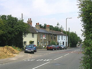
South Ockendon is a town, former civil parish and Church of England parish within the Thurrock borough in Essex in the East of England, United Kingdom. It is located on the border with Greater London, just outside the M25 motorway. The area to the north is North Ockendon. In 2019 it had an estimated population of 22,303 and in the 2021 United Kingdom census it had a population of 22,442.
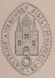
Havering, also known as Havering-atte-Bower, was a royal manor and ancient liberty whose area now forms part of, and gives its name to, the London Borough of Havering in Greater London. The manor was in the possession of the Crown from the 11th to the 19th centuries and was the location of Havering Palace from the 13th to the late 17th century. It occupied the same area as the ancient parish of Hornchurch which was divided into the three chapelries of Havering, Hornchurch and Romford.
The RM postcode area, also known as the Romford postcode area, is a group of twenty postcode districts in south-east England, within nine post towns. These cover parts of eastern Greater London and south-west Essex. Inward mail for the area is sorted, along with mail for the E and IG postcode areas, at the Romford Mail Centre.

West Thurrock is an area, former civil parish and traditional Church of England parish in Thurrock, Essex, England, located 18 miles (28.1 km) east south-east of Charing Cross, London.

Romford is a constituency in Greater London represented in the House of Commons of the UK Parliament since 2001 by Andrew Rosindell, a Conservative.

The Thames Chase Community Forest is a community forest of 9842 hectares located in 47 sites in London and Essex, England. Established in 1990, the community forest is administered by the Thames Chase Trust, with a stated aim "to renew and regenerate the landscape at the edge of East London and South Essex by creating a varied wooded landscape for local people to influence, create, use, enjoy and cherish".

Hornchurch was a local government district in southwest Essex from 1926 to 1965, formed as an urban district for the civil parish of Hornchurch. It was greatly expanded in 1934 with the addition of Cranham, Great Warley, Rainham, Upminster and Wennington; and in 1936 by gaining North Ockendon. Hornchurch Urban District Council was based at Langtons House in Hornchurch from 1929. The district formed a suburb of London and with a population peaking at 131,014 in 1961, it was one of the largest districts of its type in England. It now forms the greater part of the London Borough of Havering in Greater London.

Great Warley is a village in the Warley ward of Brentwood borough in Essex, England. It is situated to the far south west of the county and near to the Greater London boundary and the M25 motorway.

West Horndon is a village and civil parish in the south of the Borough of Brentwood in Essex, England. It is located 20 miles (32 km) east-northeast of Charing Cross in Central London. West Horndon civil parish was abolished in 1934 and created again in 2003 with new boundaries following a petition by residents in 2002. With a population of 1,650 in 2021, it is a predominantly rural parish with some residential and light industrial development. The civil parish includes the village of East Horndon. Dunton Hills, also within the civil parish, is planned to be the location of a new 3,700 home garden village. The local council of the parish is West Horndon Parish Council.
Romford Rural District was a local government district in southwest Essex, England from 1894 to 1934. It surrounded, but did not include, Romford which formed a separate urban district. During the life of the district the area changed in use from rural farm land to sprawling London suburb and in 1926 much of it was removed to form new urban districts.

Bulphan is a village and former civil parish in the borough of Thurrock in Essex and one of the traditional parishes in Thurrock. As of the 2021 census, it had a population of 774.
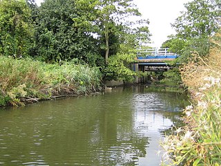
The Mardyke is a small river, mainly in Thurrock, that flows into the River Thames at Purfleet, close to the Queen Elizabeth II Bridge. In part, it forms the boundary between the Essex hundreds of Barstable and Chafford. The river gives its name to the Mardyke Valley—a project aimed at increasing appreciation and usage of recreational land around the Mardyke.
