Related Research Articles

The Alps form part of a Cenozoic orogenic belt of mountain chains, called the Alpide belt, that stretches through southern Europe and Asia from the Atlantic all the way to the Himalayas. This belt of mountain chains was formed during the Alpine orogeny. A gap in these mountain chains in central Europe separates the Alps from the Carpathians to the east. Orogeny took place continuously and tectonic subsidence has produced the gaps in between.

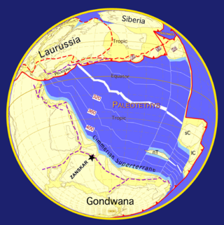
Laurasia was the more northern of two large landmasses that formed part of the Pangaea supercontinent from around 335 to 175 million years ago (Mya), the other being Gondwana. It separated from Gondwana 215 to 175 Mya during the breakup of Pangaea, drifting farther north after the split and finally broke apart with the opening of the North Atlantic Ocean c. 56 Mya. The name is a portmanteau of Laurentia and Eurasia.

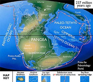
The Tethys Ocean, also called the Tethys Sea or the Neo-Tethys, was a prehistoric ocean during much of the Mesozoic Era and early-mid Cenozoic Era. It was the predecessor to the modern Indian Ocean, the Mediterranean Sea, and the Eurasian inland marine basins.

Panthalassa, also known as the Panthalassic Ocean or Panthalassan Ocean, was the vast superocean that encompassed planet Earth and surrounded the supercontinent Pangaea, the latest in a series of supercontinents in the history of Earth. During the Paleozoic–Mesozoic transition, the ocean occupied almost 70% of Earth's surface, with the supercontinent Pangaea taking up less than half. The original, ancient ocean floor has now completely disappeared because of the continuous subduction along the continental margins on its circumference. Panthalassa is also referred to as the Paleo-Pacific or Proto-Pacific because the Pacific Ocean is a direct continuation of Panthalassa.

Pannotia, also known as the Vendian supercontinent, Greater Gondwana, and the Pan-African supercontinent, was a relatively short-lived Neoproterozoic supercontinent that formed at the end of the Precambrian during the Pan-African orogeny, during the Cryogenian period and broke apart 560 Ma with the opening of the Iapetus Ocean, in the late Ediacaran and early Cambrian. Pannotia formed when Laurentia was located adjacent to the two major South American cratons, Amazonia and Río de la Plata. The opening of the Iapetus Ocean separated Laurentia from Baltica, Amazonia, and Río de la Plata. A 2022 paper argues that Pannotia never fully existed, reinterpreting the geochronological evidence: "the supposed landmass had begun to break up well before it was fully assembled". However, the assembly of the next supercontinent Pangaea is well established.

Avalonia was a microcontinent in the Paleozoic era. Crustal fragments of this former microcontinent underlie south-west Great Britain, southern Ireland, and the eastern coast of North America. It is the source of many of the older rocks of Western Europe, Atlantic Canada, and parts of the coastal United States. Avalonia is named for the Avalon Peninsula in Newfoundland.
The geology of the Himalayas is a record of the most dramatic and visible creations of the immense mountain range formed by plate tectonic forces and sculpted by weathering and erosion. The Himalayas, which stretch over 2400 km between the Namcha Barwa syntaxis at the eastern end of the mountain range and the Nanga Parbat syntaxis at the western end, are the result of an ongoing orogeny — the collision of the continental crust of two tectonic plates, namely, the Indian Plate thrusting into the Eurasian Plate. The Himalaya-Tibet region supplies fresh water for more than one-fifth of the world population, and accounts for a quarter of the global sedimentary budget. Topographically, the belt has many superlatives: the highest rate of uplift, the highest relief, among the highest erosion rates at 2–12 mm/yr, the source of some of the greatest rivers and the highest concentration of glaciers outside of the polar regions. This last feature earned the Himalaya its name, originating from the Sanskrit for "the abode of the snow".

The Caledonian orogeny was a mountain-building cycle recorded in the northern parts of the British Isles, the Scandinavian Caledonides, Svalbard, eastern Greenland and parts of north-central Europe. The Caledonian orogeny encompasses events that occurred from the Ordovician to Early Devonian, roughly 490–390 million years ago (Ma). It was caused by the closure of the Iapetus Ocean when the Laurentia and Baltica continents and the Avalonia microcontinent collided.

The Variscan orogeny, or Hercynian orogeny, was a geologic mountain-building event caused by Late Paleozoic continental collision between Euramerica (Laurussia) and Gondwana to form the supercontinent of Pangaea.

The Paleo-Tethys or Palaeo-Tethys Ocean was an ocean located along the northern margin of the paleocontinent Gondwana that started to open during the Middle Cambrian, grew throughout the Paleozoic, and finally closed during the Late Triassic; existing for about 400 million years.
The Proto-Tethys or Theic Ocean was an ancient ocean that existed from the latest Ediacaran to the Carboniferous.
Cimmeria was an ancient continent, or, rather, a string of microcontinents or terranes, that rifted from Gondwana in the Southern Hemisphere and was accreted to Eurasia in the Northern Hemisphere. It consisted of parts of present-day Turkey, Iran, Afghanistan, Pakistan, Tibet, China, Myanmar, Thailand, and Malaysia. Cimmeria rifted from the Gondwanan shores of the Paleo-Tethys Ocean during the Early Permian and as the Neo-Tethys Ocean opened behind it, during the Permian, the Paleo-Tethys closed in front of it. Because the different chunks of Cimmeria drifted northward at different rates, a Meso-Tethys Ocean formed between the different fragments during the Cisuralian. Cimmeria rifted off Gondwana from east to west, from Australia to the eastern Mediterranean. It stretched across several latitudes and spanned a wide range of climatic zones.

Gondwana was a large landmass, sometimes referred to as a supercontinent. The remnants of Gondwana make up around two-thirds of today's continental area, including South America, Africa, Antarctica, Australia, Zealandia, Arabia, and the Indian Subcontinent.

The Rhenohercynian Zone or Rheno-Hercynian zone in structural geology describes a fold belt of west and central Europe, formed during the Hercynian orogeny. The zone consists of folded and thrust Devonian and early Carboniferous sedimentary rocks that were deposited in a back-arc basin along the southern margin of the then existing paleocontinent Laurussia.
The Saxothuringian Zone, Saxo-Thuringian zone or Saxothuringicum is in geology a structural or tectonic zone in the Hercynian or Variscan orogen of central and western Europe. Because rocks of Hercynian age are in most places covered by younger strata, the zone is not everywhere visible at the surface. Places where it crops out are the northern Bohemian Massif, the Spessart, the Odenwald, the northern parts of the Black Forest and Vosges and the southern part of the Taunus. West of the Vosges terranes on both sides of the English Channel are also seen as part of the zone, for example the Lizard complex in Cornwall or the Léon Zone of the Armorican Massif (Brittany).
The Moldanubian Zone is in the regional geology of Europe a tectonic zone formed during the Variscan or Hercynian Orogeny. The Moldanubian Zone crops out in the Bohemian Massif and the southern part of the Black Forest and Vosges and contains the highest grade metamorphic rocks of Variscan age in Europe.
The Massif Central is one of the two large basement massifs in France, the other being the Armorican Massif. The Massif Central's geological evolution started in the late Neoproterozoic and continues to this day. It has been shaped mainly by the Caledonian orogeny and the Variscan orogeny. The Alpine orogeny has also left its imprints, probably causing the important Cenozoic volcanism. The Massif Central has a very long geological history, underlined by zircon ages dating back into the Archaean 3 billion years ago. Structurally it consists mainly of stacked metamorphic basement nappes.
The Armorican terrane, Armorican terrane assemblage, or simply Armorica, was a microcontinent or group of continental fragments that rifted away from Gondwana towards the end of the Silurian and collided with Laurussia towards the end of the Carboniferous during the Variscan orogeny. The name is taken from Armorica, the Gaulish name for a large part of northwestern France that includes Brittany, as this matches closely to the present location of the rock units that form the main part of this terrane.

The Lhasa terrane is a terrane, or fragment of crustal material, sutured to the Eurasian plate during the Cretaceous that forms present-day southern Tibet. It takes its name from the city of Lhasa in the Tibet Autonomous Region, China. The northern part may have originated in the East African Orogeny, while the southern part appears to have once been part of Australia. The two parts joined, were later attached to Asia, and then were impacted by the collision of the Indian plate that formed the Himalayas.
References
- ↑ Muttoni et al. 2009 , Fig. 2, p. 19
- ↑ Stampfli, von Raumer & Borel 2002 , Middle Devonian Phase, p. 272
- ↑ Stampfli, von Raumer & Borel 2002 , Fig. 3, pp. 268–629
- ↑ Fielding, Frank & Isbell 2008 , pp. 11
- ↑ Stampfli 2000 , Palaeotethys, p. 3; "it contains most of the areas devastated by Attila!"
Sources
- Muttoni, G.; Gaetani, M.; Kent, D. V.; Sciunnach, D.; Angiolini, L.; Berra, F.; Garzanti, E.; Mattei, M.; Zanchi, A. (2009). "Opening of the Neo-Tethys Ocean and the Pangea B to Pangea A transformation during the Permian" (PDF). GeoArabia. 14 (4): 17–48. doi:10.2113/geoarabia140417. S2CID 53416016. Archived from the original (PDF) on 9 August 2017. Retrieved 1 November 2015.
- Stampfli, G. M. (2000). "Tethyan oceans" (PDF). Geological Society, London, Special Publications. 173 (1): 1–23. Bibcode:2000GSLSP.173....1S. doi:10.1144/GSL.SP.2000.173.01.01. S2CID 219202298 . Retrieved 30 November 2019.
- Stampfli, G. M.; von Raumer, J. F.; Borel, G. D. (2002). "Paleozoic evolution of pre-Variscan terranes: From Gondwana to the Variscan collision" (PDF). In Catalán, M.; Hatcher, R. D. Jr.; Arenas, R.; et al. (eds.). Variscan-Appalachian dynamics: The building of the late Paleozoic basement (PDF). Boulder, Colorado: Geological Society of America Special Paper 364. pp. 263–280. doi:10.1130/0-8137-2364-7.263. ISBN 9780813723648 . Retrieved 1 January 2017.
- Fielding, Christopher; Frank, Tracy; Isbell, John (1 January 2008). Resolving the Late Paleozoic Ice Age in Time and Space. Geological Society of America. ISBN 9780813724416 . Retrieved 4 November 2019.
| | This plate tectonics article is a stub. You can help Wikipedia by expanding it. |