Hunsingo

Last updated
Location of the regions of rural Groningen Groningenhistorisch.png
Location of the regions of rural Groningen
Hunsingo in the year 1300 Seelandehunsigo.png
Hunsingo in the year 1300

Hunsingo (Gronings: Hunzego or Hunzengo) is a region in the province of Groningen, Netherlands, between the Reitdiep and Maarvliet. Hunsingo was one of three Ommelanden. It is bordered to the north by the Wadden Sea, to the east Fivelingo, in the west to the Westerkwartier and Friesland and in the south, Gorecht. The region corresponds to the current municipalities De Marne, Eemsmond, the majority of the municipalities of Bedum and Winsum and the former municipality of Middelstum.

Contents

The name means area (go or gau) of the Hunze River. The Hunze no longer exists after the construction of the Reitdiep canal. Originally the Hunze followed a different course with its mouth at Pieterburen on the Wadden Sea, and divided Hunsingo into two parts. [1]

Hunsingo was the first member of the Ommelander Union. The main town was Winsum where the Ommelanden for a short time held their own meetings. The area is largely similar to the Hoogeland region although that is more a geographical indication, while Hunsingo was an administrative unit.

The three Wadden islands of Rottumerplaat, Rottumeroog and Zuiderduintjes belong to this area.

History

Windmill "Hunsingo" in Onderdendam, now a bed and breakfast 1383 Onderdendam.JPG
Windmill "Hunsingo" in Onderdendam, now a bed and breakfast

Like Fivelingo, Hunsingo was originally a Frisian region. Ludger was assigned in 787 the mission areas including the regions of Hugmerthi (Humsterland), Hunusga and Fivilga. The monastery of Fulda received in the ninth century a donation in Middelstum "in pago Hunergewe in regione fresonum". In 1057 the region of "Hunsingo" is mentioned as part of a county donated by the Holy Roman Emperor Henry IV, under the regency of his mother, to the Archbishop of Hamburg, Adalbert. Before that, the Saxon noble house of Brunonen had the fief of the county. In the eleventh century, coins were minted in Winsum, which suggests that Winsum was the capital of the region. In later times Onderdendam became the central place of the region.

The population always spoke an East Frisian, but, by uniting the city of Groningen with the surrounding district, East Frisian has merged with Low Saxon (Platduuts) of the city, although the language of the surrounding countryside still retains a strong East Frisian substrate. In the 13th century laws were recorded in Latin or in the Hunsingoer dialect of East Frisian. [3] [4]

In the seventeenth and eighteenth centuries, Hunsingo was the first member of the Ommelander Union. The most important place in Hunsingo, Winsum, was for a brief period where the Ommelander jonkers held their meetings. Winsum was originally therefore a settlement with an urban character. The proximity of the city of Groningen, however, did not allow it the opportunity to become a real city.

The region was originally divided into two or three subdistricts, which coincided with the oldest seenddistricts (sees or mother parishes). Of these the parishes of Usquert and Leens were the oldest:

De Marne was originally part of the region Humsterland (Westerkwartier); however, the emergence of the Reitdiep and the exploitation of the underlying peat led to it becoming a separate seenddistrict. The district, Middag, is also recognized in Westerkwartier since the sixteenth century. The peat area of Innersdijk (around Bedum) was separated from the Oosterambt around the fourteenth century, while De Marne in the fifteenth century temporarily disintegrated into an eastern and a western part. The various districts were characterized by considerable autonomy, the joint representatives gathered in Onderdendam, that was exactly on the border of the main subdivisions. [5]

In 1659 a new classification was ordered by the States General:

Between 1830 and 1880, 5,900 people emigrated from Hunsingo, almost all going to the United States. This was two-thirds of all emigrations from the entire province of Groningen. Most of the emigrants from Hunsingo ended up in western Michigan, followed by Chicago and a smaller group going to Lafayette, Indiana. [6]

Hunsingo was also the name of the water authority in the area, charged with the management of water levels, canals, dykes and storm barriers. The Hunsingo water board existed from 1856 to 1994 when it was merged into the Noorderzijlvest water board.

Character

Hotel called "Wapen van Hunsingo" (coat of arms of Hunsingo) in Pieterburen Pieterburen RA.JPG
Hotel called "Wapen van Hunsingo" (coat of arms of Hunsingo) in Pieterburen

In Hunsingo, many borg (fortified great houses) were found. This does not imply that there was more nobility in Hunsingo than in the remainder of Groningen. Many of the borgs were destroyed, both by officials and by the dissatisfied people. A famous borg in Hunsingo is the Menkemaborg at Uithuizen. Another is Verhildersum at Leens.

Hunsingo is characterized by meadows, mounds and dikes. Hunsingo has expanded by reclaiming land that initially is filled in by the natural settlement of sedimentary clay by the sea near the dikes (endiking). This area above the old dikes is also known as the Groningen Hogeland (high land). When the new deposits had reached sufficient size, that area was then secured by the construction of a new dyke.[ citation needed ]

Today Hunsingo is one of the main economic arteries of Groningen. This is due to the Eemshaven on the eastern point and the Lauwersmeer National Park and shrimping village of Zoutkamp on the western point. The shrimp company Heiploeg is located in Zoutland. This is the largest shrimp supplier in Europe.

See also

Related Research Articles

Groningen (province) Northeasternmost province of the Netherlands

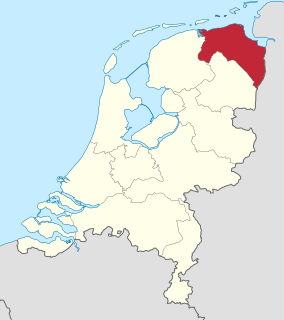
Groningen is the northeasternmost province of the Netherlands. It borders on Friesland to the west, Drenthe to the south, the German state of Lower Saxony to the east, and the Wadden Sea to the north. As of February 2020, Groningen had a population of 586,309 and a total area of 2,960 km2 (1,140 sq mi).

Wadden Sea An intertidal zone in the southeastern part of the North Sea (Netherlands, Germany and Denmark)

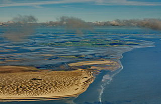
The Wadden Sea is an intertidal zone in the southeastern part of the North Sea. It lies between the coast of northwestern continental Europe and the range of low-lying Frisian Islands, forming a shallow body of water with tidal flats and wetlands. It has a high biological diversity and is an important area for both breeding and migrating birds. In 2009, the Dutch and German parts of the Wadden Sea were inscribed on UNESCO's World Heritage List and the Danish part was added in June 2014.

Frisia Cross-border cultural region in Northern Europe

Frisia is a cross-border cultural region in Northwestern Europe. Stretching along the Wadden Sea, it encompasses the north of the Netherlands and parts of northwestern Germany. The region is traditionally inhabited by the Frisians, a West Germanic ethnic group.

De Marne Municipality in Groningen, Netherlands

De Marne is a former municipality in the northeast of the Netherlands. On 1 January 2019 it merged with the municipalities of Bedum, Eemsmond and Winsum to form the new municipality Het Hogeland.

Frisian Islands

The Frisian Islands, also known as the Wadden Islands or the Wadden Sea Islands, form an archipelago at the eastern edge of the North Sea in northwestern Europe, stretching from the northwest of the Netherlands through Germany to the west of Denmark. The islands shield the mudflat region of the Wadden Sea from the North Sea.

Gronings dialect Friso-Saxon dialect group

Gronings, is a collective name for some Friso-Saxon dialects spoken in the province of Groningen and around the Groningen border in Drenthe and Friesland. Gronings and the strongly related varieties in East Frisia have a strong East Frisian influence and take a remarkable position within West Low German. The dialect is characterized by a typical accent and vocabulary, which differ strongly from the other Low Saxon dialects.

<i>Terp</i> Raised ground to provide a refuge from flooding

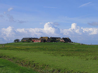
A terp, also known as a wierde, woerd, warf, warft, werf, werve, wurt or værft, is an artificial dwelling mound found on the North European Plain that has been created to provide safe ground during storm surges, high tides and sea or river flooding. The various terms used reflect the regional dialects of the North European region. In English sources, terp appears to be by far the most common term used.

Ommelanden

The Ommelanden are the parts of Groningen province that surround Groningen city. Usually mentioned as synonym for the province in the expression Stad en Ommeland.

Wangerooge Municipality in Lower Saxony, Germany

Wangerooge is one of the 32 Frisian Islands in the North Sea located close to the coasts of the Netherlands, Germany and Denmark. It is also a municipality in the district of Friesland in Lower Saxony in Germany.

West Frisia

West Frisia is a term used to refer to the traditionally Frisian areas that are located west of the Dollart, within the Netherlands. Along with East Frisia and North Frisia, it is one of the most commonly used subdivisions of Frisia.

Rheiderland

The Rheiderland is a region of Germany and the Netherlands between the River Ems and the Bay of Dollart. The German part of the Rheiderland lies in East Frisia, west of the Ems. The Dutch part lies in the Dutch province of Groningen and is mostly part of Oldambt. The Rheiderland is one of the four historic regions on the mainland in the district of Leer; the others being the Overledingerland, the Moormerland and the Lengenerland.

Ezinge Village in Groningen, Netherlands

Ezinge is a village in the Dutch province of Groningen. It is located in the municipality of Westerkwartier, about 15 km northwest of the city of Groningen. Ezinge is the oldest, constantly inhabited village in The Netherlands and is in archeological context referred to as "the Pompeii of the North".

Middelzee

The Middelzee, also called Bordine, was the estuary mouth of the River Boorne now in the Dutch province of Friesland. It ran from as far south as Sneek northward to the Wadden Sea and marked the border between main Frisian regions of Westergoa (Westergo) and Eastergoa (Oostergo). Other historical names for the Middelzee include Bordaa, Borndiep, Boerdiep, and Bordena. The names like Bordine, mean "border".

Flag of Friesland

The Flag of the province of Friesland or Frisian flag, is the official flag of the Netherlands province of Friesland.

Frisian freedom c. 800 – 1523 absence of feudalism and serfdom in Frisia

Friese Freedom or Freedom of the Frisians was the absence of feudalism and serfdom in Frisia, the area that was originally inhabited by the Frisians. Historical Frisia included the modern provinces of Friesland and Groningen, and the area of West Friesland, in the Netherlands, and East Friesland in Germany. During the period of Frisian freedom the area did not have a sovereign lord who owned and administered the land. The freedom of the Frisians developed in the context of ongoing disputes over the rights of local nobility.

Bourtange moor Bog area in northern Germany and Netherlands

The Bourtanger Moor was a bog in eastern parts in the Dutch provinces of Drenthe and Groningen and the bordering German districts of Bentheim and Emsland. A remaining stretch on the border between Drenthe and the districts Emsland and Betheim is now a nature reserve, the Internationaler Naturpark Bourtanger Moor-Bargerveen.

Great Frisian War 15th century war in Friesland

The Great Frisian War was an armed conflict in Frisia which lasted nine years in the 15th century, from 1413 to 1422.

Niehove Village in Groningen, Netherlands

Niehove is a village in the municipality of Westerkwartier in Groningen, Netherlands. The village was located on the island of Humsterland in the former Lauwerszee from c. 800 until c. 1500. It is a terp village with two ring roads and the church in the middle. The village is a protected site. In 2019, Elsevier Weekblad named Niehove the most beautiful village of the Netherlands.

References

  1. Cultural Entities (The Netherlands): Hunsingo Archived 2016-03-04 at the Wayback Machine , Lancewadplan, 2008
  2. History windmill 'Molen Hunsingo', accessed May 9, 2013
  3. The Frisian Language and Literature: A Historical Study, Thomas Hewett Waterman, Finch & Apgar, 1879, pp. 33-36
  4. "De Nederlandse en Vlaamse auteurs · DBNL".
  5. H. van Lengen, 'Tota Frisia: Sieben Seelande und mehr', in: dez. (red.), Die friesische Freiheit des Mittelalters: Leben und Legende, Aurich 2003, pp. 61-68
  6. Faith and Family, Dutch Immigration and Settlement in the United States, 1820-1920, Robert P. Swieringa, Holmes and Meier Pub., 2000, ISBN   9780841913196