Related Research Articles
Northeast Glacier is a steep, heavily crevassed glacier, 13 nautical miles long and 5 nautical miles wide at its mouth, which flows from McLeod Hill westward and then south-westwards into Marguerite Bay between the Debenham Islands and Roman Four Promontory, on the west coast of Graham Land, Antarctica.

Arrowsmith Peninsula is a cape about 40 miles (64 km) long on the west coast of Graham Land, west of Forel Glacier, Sharp Glacier and Lallemand Fjord, and northwest of Bourgeois Fjord, with Hanusse Bay lying to the northwest. It was surveyed by the Falkland Islands Dependencies Survey (FIDS) in 1955-58 and named for Edwin Porter Arrowsmith, Governor of the Falkland Islands.

The Bay of Isles is a bay 9 miles (14 km) wide and receding 3 miles (5 km), lying between Cape Buller and Cape Wilson along the north coast of South Georgia. It was discovered in 1775 by a British expedition under James Cook and so named by him because numerous islands lie in the bay. Of South Georgia's 31 breeding bird species, 17 are found here.

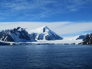
Shambles Glacier is a steep glacier 4 miles (6 km) long and 6 miles (10 km) wide, with very prominent hummocks and crevasses, flowing east between Mount Bouvier and Mount Mangin into Stonehouse Bay on the east side of Adelaide Island. It is the island's largest glacier, and provides an eastern outlet from the giant Fuchs Ice Piedmont which covers the entire western two-thirds of the island. In doing so, Shambles Glacier provides the largest 'gap' in Adelaide Island's north–south running mountain chain.

Wright Peninsula is a peninsula on the east coast of Adelaide Island, Antarctica, lying between Stonehouse Bay to the north and Ryder Bay to the south. On its northern coastline the peninsula is fringed by the Stokes Peaks; on its southern side by the Reptile Ridge. The Princess Royal Range separates the peninsula from the rest of Adelaide Island; the only 'gap' is provided by McCallum Pass.
Mount Barre is a mountain with an ice-covered, pyramidal peak, 2,195 m, standing 2 nautical miles (3.7 km) northeast of Mount Gaudry in the south part of Adelaide Island. Discovered and surveyed in 1909 by the French Antarctic Expedition under Charcot. Resurveyed in 1948 by the Falkland Islands Dependencies Survey (FIDS) and named by the United Kingdom Antarctic Place-Names Committee (UK-APC) for Michel Barre, leader of the French Antarctic Expedition to the Adelie Coast, 1951–52.
Wyatt Glacier is a steep, narrow glacier 6 nautical miles (11 km) long in southern Graham Land. It flows south from the central plateau near Beehive Hill to join the upper part of Gibbs Glacier. Photographed from the air by Ronne Antarctic Research Expedition (RARE), November 1947. Surveyed from the ground by Falkland Islands Dependencies Survey (FIDS), May 1958. Named by United Kingdom Antarctic Place-Names Committee (UK-APC) for Henry T. Wyatt of FIDS, Medical Officer at Detaille Island, 1957, and at Stonington Island, 1958.
Dalgliesh Bay is a bay, 1 nautical mile (2 km) wide and indenting 3 nautical miles (6 km), lying between Lainez Point and Bongrain Point on the west side of Pourquoi Pas Island, off the west coast of Graham Land. It was first roughly surveyed in 1936 by the British Graham Land Expedition under John Rymill. It was resurveyed in 1948 by the Falkland Islands Dependencies Survey (FIDS) and named for David G. Dalgliesh, FIDS medical officer at Stonington Island in 1948–49, who accompanied the 1948 sledge survey party to this area. Stride Peak rises to 675 m at the head of Dalgliesh Bay.
The Stokes Peaks is a group of peaks rising to about 800 m between McCallum Pass and Sighing Peak on the north side of Wright Peninsula, Adelaide Island, Antarctica. They were photographed from the air by the Falkland Islands and Dependencies Aerial Survey Expedition (FIDASE), 1956–57, and surveyed by the British Antarctic Survey (BAS), in 1961–62. They were named by the United Kingdom Antarctic Place-Names Committee (UK-APC) in 1977 for Jeffrey C.A. Stokes, Falkland Islands Dependencies Survey (FIDS) assistant surveyor, Admiralty Bay, 1959–60, and Adelaide Island, 1960–61.
Fuchs Ice Piedmont is an ice piedmont 70 nautical miles (130 km) long, extending in a northeast–southwest direction along the entire west coast of Adelaide Island. It was first mapped in 1909 by the French Antarctic Expedition under Jean-Baptiste Charcot. It was named by the Falkland Islands Dependencies Survey (FIDS) for Sir Vivian E. Fuchs, FIDS base leader and geologist at Stonington Island in 1948–49.
Turner Glacier is a glacier on the east side of Mount Liotard flowing northeast into Ryder Bay, Adelaide Island. The glacier was surveyed by Falkland Islands Dependencies Survey (FIDS), 1948, and photographed from the air by Falkland Islands and Dependencies Aerial Survey Expedition (FIDASE), 1956–57. Named by the United Kingdom Antarctic Place-Names Committee (UK-APC) in 1977 after Andrew John Turner, British Antarctic Survey (BAS) builder, Halley Station, 1973–74; Signy Island, 1974–75; Rothera Station, 1976–77, 1978–80; and Faraday Station, 1982–83.
Eros Glacier is a glacier on the east coast of Alexander Island, Antarctica, 7 nautical miles (13 km) long and 2 nautical miles (4 km) wide at its mouth, flowing southeast from the Planet Heights into George VI Sound immediately north of Fossil Bluff. It was probably first seen on November 23, 1935, by Lincoln Ellsworth, who flew directly over the glacier and obtained photos of features north and south of it. The mouth of the glacier was observed and positioned by the British Graham Land Expedition in 1936 and the Falkland Islands Dependencies Survey (FIDS) in 1948 and 1949. The glacier was mapped in detail from air photos taken by the Ronne Antarctic Research Expedition, 1947–48, by D. Searle of the FIDS in 1960. It was named by the UK Antarctic Place-Names Committee after the minor planet Eros in association with nearby Pluto Glacier and Uranus Glacier.
Mount Ethelwulf is a mainly ice-covered mountain, 2,590 metres (8,500 ft) high, standing between Mount Egbert and Mount Ethelred at the head of Tumble Glacier, in the Douglas Range of northeast Alexander Island, Antarctica. The mountain was probably first observed by Lincoln Ellsworth, who photographed the east side of the Douglas Range from the air on November 23, 1935; its east face was roughly surveyed in 1936 by the British Graham Land Expedition under John Rymill. It was resurveyed in 1948 by the Falkland Islands Dependencies Survey (FIDS) and named for Ethelwulf, Saxon King of England, 839–858. The west face of the mountain was mapped from air photos taken by the Ronne Antarctic Research Expedition, 1947–48, by D. Searle of the FIDS in 1960. Mount Ethelwulf is the fourth highest peak of Alexander Island, succeeded by Mount Paris and proceeded by Mount Huckle.
Fricker Glacier is a glacier, 10 nautical miles (19 km) long, which lies close north of Tindal Bluff and Monnier Point and flows in a northeasterly direction into the southwest side of Mill Inlet, on the east coast of Graham Land, Antarctica. It was charted by the Falkland Islands Dependencies Survey (FIDS) and photographed from the air by the Ronne Antarctic Research Expedition in 1947, and was named by the FIDS for Karl Fricker, a German Antarctic historian.
Mount Liotard is a mountain having a conspicuous ice-covered peak, 2,225 metres (7,300 ft) high, standing midway between Mount Gaudry and Mount Ditte in the south part of Adelaide Island, Antarctica. It was discovered and first surveyed by the Fourth French Antarctic Expedition in 1909. It was resurveyed in 1948 by the Falkland Islands Dependencies Survey (FIDS) and named by the UK Antarctic Place-Names Committee for Andre F. Liotard, a French observer with the FIDS in 1947–48 and the leader of the French Antarctic Expedition, 1949–51.
The Haslam Heights are a line of peaks trending north-northeast–south-southwest, rising to about 1,000 metres (3,300 ft) to the west of Vallot Glacier and Nye Glacier in Arrowsmith Peninsula, Graham Land, Antarctica. They were probably first seen by the French Antarctic Expedition, 1908–10 under Jean-Baptiste Charcot, which roughly charted the area in 1909. They were roughly mapped by the Falkland Islands Dependencies Survey (FIDS) in 1948, and named in 1985 by the UK Antarctic Place-Names Committee (UK-APC) after Rear Admiral Sir David W. Haslam, Hydrographer of the Navy, 1975–85.
The Tyndall Mountains are a group of mountains close south of Avsyuk Glacier in central Arrowsmith Peninsula, Graham Land. Photographed from the air by FIDASE, 1956–57. Mapped by Falkland Islands Dependencies Survey (FIDS) from surveys and air photos, 1948–59. Named by United Kingdom Antarctic Place-Names Committee (UK-APC) for John Tyndall (1820–93), Irish mountaineer and pioneer glaciologist, author of many works on glaciers and the physical properties of ice.
The Terra Firma Islands are a small group of islands lying 8 nautical miles north of Cape Berteaux, off the west coast of Graham Land in West Antarctica.
Relay Hills is a group of low, ice-covered hills, mainly conical in shape, between Mount Edgell and Kinnear Mountains in western Antarctic Peninsula. First roughly surveyed from the ground by British Graham Land Expedition (BGLE), 1936–37. Photographed from the air by Ronne Antarctic Research Expedition (RARE), November 1947. Resurveyed by Falkland Islands Dependencies Survey (FIDS), November 1958. The name, applied by the United Kingdom Antarctic Place-Names Committee (UK-APC), arose because both the BGLE and the FIDS sledging parties had to relay their loads through this area to the head of Prospect Glacier.
Robillard Glacier is a narrow glacier flowing east-northeast and entering the north side of the head of Solberg Inlet, on the east coast of Graham Land. It was discovered by members of East Base of the United States Antarctic Service (USAS), 1939–41, and was photographed from the air in 1947 by the Ronne Antarctic Research Expedition (RARE), under Ronne, and charted in 1948 by the Falkland Islands Dependencies Survey (FIDS). It was named by Ronne for Captain George Robillard, U.S. Navy, of the legal section of the Bureau of Ships, who assisted in gaining Congressional support which resulted in procuring the expedition ship.
References
- ↑ "Hunt Peak". Geographic Names Information System . United States Geological Survey, United States Department of the Interior . Retrieved 2012-07-04.
![]() This article incorporates public domain material from "Hunt Peak". Geographic Names Information System . United States Geological Survey.
This article incorporates public domain material from "Hunt Peak". Geographic Names Information System . United States Geological Survey.
| | This Adelaide Island location article is a stub. You can help Wikipedia by expanding it. |