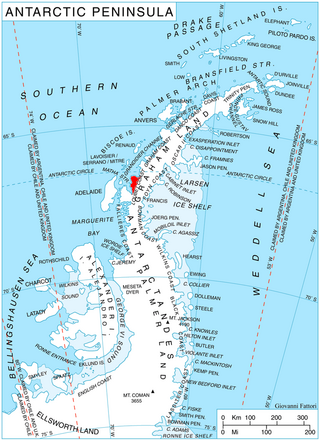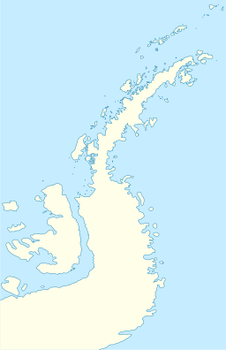
Adelaide Island is a large, mainly ice-covered island, 139 kilometres (75 nmi) long and 37 kilometres (20 nmi) wide, lying at the north side of Marguerite Bay off the west coast of the Antarctic Peninsula. The Ginger Islands lie off the southern end. Mount Bodys is the easternmost mountain on Adelaide Island, rising to over 1,220 m. The island lies within the Argentine, British and Chilean Antarctic claims.

Arrowsmith Peninsula is a cape about 40 miles (64 km) long on the west coast of Graham Land, west of Forel Glacier, Sharp Glacier and Lallemand Fjord, and northwest of Bourgeois Fjord, with Hanusse Bay lying to the northwest. It was surveyed by the Falkland Islands Dependencies Survey (FIDS) in 1955-58 and named for Edwin Porter Arrowsmith, Governor of the Falkland Islands.
Blaiklock Island is a high and rugged, irregular-shaped island 17 kilometres (9 nmi) long, lying between Bigourdan Fjord and Bourgeois Fjord. It is separated from Pourquoi Pas Island by The Narrows and from the west coast of Graham Land by Jones Channel. The feature was partially surveyed in 1936 by the British Graham Land Expedition under Rymill, at which time it was charted as a promontory. It was determined to be an island in 1949 by Kenneth V. Blaiklock, a Falkland Islands Dependencies Survey (FIDS) surveyor for whom it is named.
Mount St. Louis is a mountain on Arrowsmith Peninsula in Graham Land, Antarctica. Its ice-covered slopes rise to 1,280 m (4,200 ft), making it a prominent landmark immediately east of The Gullet. It was first sighted and roughly charted in 1909 by the French Antarctic Expedition (FAE) under J.B. Charcot. Surveyed in 1948 by the Falklands Islands Dependencies Survey (FIDS) who named it for Canadian pilot Peter B. St. Louis.
Barlas Channel is a channel, 8 nautical miles (15 km) long and 2 nautical miles (4 km) wide, in the northern part of Laubeuf Fjord, extending southwest from The Gullet and separating Day Island from Adelaide Island. It was first roughly surveyed in 1936 by the British Graham Land Expedition under John Rymill, and resurveyed in 1948 by the Falkland Islands Dependencies Survey, who named it for William Barlas.
Bartók Glacier is a glacier, 7 nautical miles (13 km) long and 3 nautical miles (6 km) wide, flowing southwest from the southern end of the Elgar Uplands in the northern part of Alexander Island. It was first photographed from the air and roughly mapped by the British Graham Land Expedition in 1937, and more accurately mapped from air photos taken by the Ronne Antarctic Research Expedition, 1947–48, by D. Searle of the Falkland Islands Dependencies Survey in 1960. It was named by the UK Antarctic Place-Names Committee after the Hungarian composer Béla Bartók.
Buchanan Passage is a marine channel separating Liard Island from Adelaide Island at the north end of Hanusse Bay. It was discovered and first charted by the French Antarctic Expedition, 1908–10, under Jean-Baptiste Charcot, and named by the UK Antarctic Place-Names Committee for Captain Peter Buchanan, Royal Navy, commanding officer of HMS Endurance in the Antarctic Peninsula area, 1968–70, who proved that the passage can be used to approach Marguerite Bay from the North, through The Gullet.
Nautilus Head is a prominent headland rising to 975 m near the northeast extremity of Pourquoi Pas Island, off the west coast of Graham Land. It was first surveyed in 1936 by the British Graham Land Expedition (BGLE) under Rymill and resurveyed in 1948 by the Falkland Islands Dependencies Survey (FIDS) who named it after the submarine Nautilus in Jules Verne's Twenty Thousand Leagues Under The Sea. Other features on Pourquoi Pas Island are named after characters from that book.
Day Island is an island, 7 nautical miles (13 km) long and 3 nautical miles (6 km) wide, immediately south of The Gullet and 2 nautical miles (4 km) north of Wyatt Island in the northern part of Laubeuf Fjord, off the west coast of Graham Land in the Antarctic Peninsula. It was first surveyed in 1936 by the British Graham Land Expedition under John Rymill, who gave it the provisional name Middle Island. It was resurveyed in 1948 by the Falkland Islands Dependencies Survey, who renamed it for Vice Admiral Sir Archibald Day, Hydrographer of the Navy.
Krebs Glacier is a glacier flowing west into the head of Charlotte Bay on the west coast of Graham Land, Antarctica. It was charted by the Belgian Antarctic Expedition under Gerlache, 1897–99, and was named by the UK Antarctic Place-Names Committee in 1960 for Arthur Constantin Krebs, who, with Charles Renard, constructed and flew the first dirigible airship capable of steady flight under control, in 1884.
Gunnel Channel is a channel, 0.5 nautical miles (1 km) wide and 7 nautical miles (13 km) long, situated in the south part of Hanusse Bay and separating Hansen Island from the west coast of Graham Land, Antarctica. It was first observed from the air and roughly charted in 1936 by the British Graham Land Expedition under John Rymill. It was surveyed from the ground in 1948 by the Falkland Islands Dependencies Survey who gave this descriptive name. The channel gives a false impression of such narrowness that a boat could not navigate it without scraping her "gunnels" (gunwales) on either side.
Forel Glacier is a glacier 1.5 nautical miles (3 km) wide and 4 nautical miles (7 km) long, flowing southwest into Blind Bay, on the west coast of Graham Land, Antarctica. It was first roughly surveyed in 1936 by the British Graham Land Expedition under John Rymill. Its lower reaches were surveyed in 1949 by the Falkland Islands Dependencies Survey, and the glacier named by them for François-Alphonse Forel, a noted Swiss glacier physicist and author, and first President of the International Commission of Glaciers in 1894.
Hansen Island is an island 6 nautical miles (11 km) long and 3 nautical miles (6 km) wide, lying immediately north of The Gullet at the head of Hanusse Bay, off the west coast of Graham Land, Antarctica. It was first surveyed in 1936 by the British Graham Land Expedition (BGLE) under John Rymill, who used the provisional name "North Island" for this feature. The island was resurveyed in 1948 by the Falkland Islands Dependencies Survey, and was renamed in 1954 by the UK Antarctic Place-Names Committee for Leganger H. Hansen, manager at Messrs. Christian Salvesen's whaling station at Leith Harbor, South Georgia, 1916–37, who gave great assistance to the BGLE, 1934–37.
Hinks Channel is an arc-shaped channel in the northern part of Laubeuf Fjord, 2 nautical miles (4 km) wide and 11 nautical miles (20 km) long, which extends from The Gullet and separates Day Island on the west from Arrowsmith Peninsula and Wyatt Island on the east, off the west coast of Graham Land, Antarctica. It was first roughly surveyed in 1936 by the British Graham Land Expedition under Rymill, and was resurveyed in 1948 by the Falkland Islands Dependencies Survey who named it for Arthur R. Hinks.
The Tyndall Mountains are a group of mountains close south of Avsyuk Glacier in central Arrowsmith Peninsula, Graham Land. Photographed from the air by FIDASE, 1956–57. Mapped by Falkland Islands Dependencies Survey (FIDS) from surveys and air photos, 1948–59. Named by United Kingdom Antarctic Place-Names Committee (UK-APC) for John Tyndall (1820–93), Irish mountaineer and pioneer glaciologist, author of many works on glaciers and the physical properties of ice.

McCall Point is a point on the east side of Lallemand Fjord, 4 nautical miles (7 km) northwest of Salmon Cove on the west coast of Pernik Peninsula, on the Loubet Coast of Graham Land, Antarctica. It was mapped from air photos taken by the Falkland Islands and Dependencies Aerial Survey Expedition, 1956–57, and was named by the UK Antarctic Place-Names Committee after American engineer John G. McCall (1923–54) of the University of Alaska, who first measured the detailed internal movement of a cirque glacier in 1951–52.
Tickle Channel is a narrow channel in the south part of Hanusse Bay, from 1 to 3 nautical miles (6 km) wide and 5 nautical miles (9 km) long, extending northward from The Gullet and separating Hansen Island from the east extremity of Adelaide Island. First seen from the air by the British Graham Land Expedition (BGLE) on a flight in February 1936. Surveyed from the ground in 1948 by the Falkland Islands Dependencies Survey (FIDS), who applied this descriptive name. In Newfoundland and Labrador a tickle is a narrow water passage as between two islands.
Kerr Point is a point 2 nautical miles (4 km) southeast of Georges Point, on the east side of Rongé Island, off the west coast of Graham Land, Antarctica. It was charted by the Belgian Antarctic Expedition under Gerlache, 1897–99, and was named by the UK Antarctic Place-Names Committee in 1960 for Adam J. Kerr, Second Officer of RRS Shackleton, who sounded the adjacent Errera Channel in 1956–57.
The Reference Islands is a group of rocky islands 2 nautical miles (3.7 km) west-northwest of the west tip of Neny Island and 1.5 nautical miles (2.8 km) southeast of Millerand Island, lying in Marguerite Bay off the west coast of Graham Land. First roughly charted in 1936 by the British Graham Land Expedition (BGLE) under Rymill. The islands were surveyed by the Falkland Islands Dependencies Survey (FIDS) in 1947, and so named by them because they served as a convenient reference point for survey work.
The Lassus Mountains are a large group of mountains, 15 nautical miles (28 km) long and 3 nautical miles (6 km) wide, rising to 2,100 metres (6,900 ft) and extending south from Palestrina Glacier in the northwest part of Alexander Island, Antarctica. They overlook Lazarev Bay and a few minor islands within the bay such as Dint Island and Umber Island; Haydn Inlet lies to the south while the Havre Mountains lie immediately north.


