
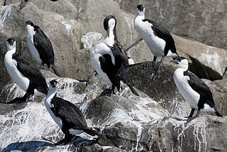
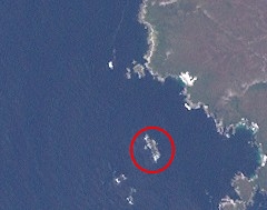
Pedra Branca is a rock islet or small island, located in the Southern Ocean, off the southern coast of Tasmania, Australia. The island is situated approximately 26 km (16 mi) south southeast of South East Cape and is contained within the Southwest National Park, part of the Tasmanian Wilderness World Heritage Site. An erosional remnant of the Tasmanian mainland, the island is approximately 270 m (890 ft) long, 100 m (330 ft) wide, with an elevation of 60 m (200 ft) above sea level. The island is estimated to have separated from the Tasmanian mainland at least 15,000 years ago.

Eddystone is a tower-shaped rock or small island, located in the Southern Ocean, off the southern coast of Tasmania, Australia. The island is situated approximately 27 km (17 mi) from the South East Cape on a bearing of 149° and is contained within the Southwest National Park, part of the Tasmanian Wilderness World Heritage Site. An erosional remnant of the Tasmanian mainland with an elevation of 30 m (98 ft) above sea level, the island is estimated to have separated from the Tasmanian mainland at least 15,000 years ago.

Mewstone is an unpopulated island, composed of muscovite granite, located close to the south coast of Tasmania, Australia. The 13.1-hectare (32-acre) island has steep cliffs and a small flat summit and is part of the Pedra Branca group, lying 12 kilometres (7.5 mi) southeast of Maatsuyker Island, and 22 kilometres (14 mi) off the south coast of Tasmania. Mewstone comprises part of the Southwest National Park and the Tasmanian Wilderness World Heritage Site.
The Sidmouth Rock is a rock islet or small island, located in the Southern Ocean, off the southern coast of Tasmania, Australia. The island is situated approximately 28 kilometres (17 mi) south-east of South East Cape and is contained within the Southwest National Park, part of the Tasmanian Wilderness World Heritage Site. An erosional remnant of the Tasmanian mainland with a diameter of 90 metres (300 ft), the island is estimated to have separated from the Tasmanian mainland at least 15,000 years ago.

The Trumpeter Islets comprise a group of two unpopulated islets, with a combined area of about a hectare, located close to the south-western coast of Tasmania, Australia. Situated some 6 kilometres (3.7 mi) where the mouth of Port Davey meets the Southern Ocean, the 1-hectare (2.5-acre) island is part of the Trumpeter Islets Group, and comprises part of the Southwest National Park and the Tasmanian Wilderness World Heritage Site.
The Hunter Island, the main island of the Hunter Island Group, is a 7,330-hectare (18,100-acre) island, located in Bass Strait, that lies between King Island and north-west Tasmania, Australia.
The Albatross Island, part of the Hunter Island Group, is an 18-hectare (44-acre) island and nature reserve located in Bass Strait, that lies between north-west Tasmania and King Island, Australia. The Peerapper name for the island is Tangatema.

Penguin Islet is a small island nature reserve with an area of 3.46 ha in Bass Strait, south-eastern Australia. It is part of Tasmania’s Hunter Island Group which lies between north-west Tasmania and King Island. It is notable as the only pelican colony in western Bass Strait.

Black Pyramid Rock is an island nature reserve, with an area of 40 ha, in Bass Strait, south-eastern Australia. It is part of Tasmania’s Hunter Island Group which lies between north-west Tasmania and King Island. It is part of the Albatross Island and Black Pyramid Rock Important Bird Area. It is notable for its Australasian gannet colony which, at over 12,000 pairs, is the largest in Tasmania and supports about 20% of the world population of the species.

Trefoil Island , officially known as titima / Trefoil Island, is an island with an area of 115.79 ha, in south-eastern Australia. It is part of Tasmania’s Trefoil Island Group, lying close to Cape Grim, Tasmania's most north-westerly point, in Bass Strait. It is owned by the Trefoil Island Aboriginal Cooperative and is home to an estimated 1.5 million breeding pairs of short-tailed shearwaters, which are subject to annual muttonbirding activities. Approval is required to visit.

Little Trefoil Island is a small island with an area of 0.64 ha, in south-eastern Australia. It is part of Tasmania’s Trefoil Island Group, lying close to Cape Grim, Tasmania's most north-westerly point, in Bass Strait.

The Henderson Islets are a group of two adjacent small rocky islands, with a combined area of 0.41 ha, in south-eastern Australia. They are part of Tasmania’s Trefoil Island Group, lying close to Cape Grim, Tasmania's most north-westerly point, in Bass Strait.

The Harbour Islets are a group of two adjacent small rocky islands, joined at low tide, part of Tasmania’s Trefoil Island Group, lying close to Cape Grim, Tasmania's most north-westerly point, in Bass Strait, with a combined area of 3.13 ha, in south-eastern Australia.

Night Island is a small granite island, with an area of 2.59 ha, is part of the Preservation Island Group, lying in eastern Bass Strait south of Cape Barren Island in the Furneaux Group, Tasmania, Australia.
The Little Waterhouse Island, part of the Waterhouse Island Group, is a 2.5-hectare (6.2-acre) granite island situated in Banks Strait, part of Bass Strait, lying close to the north-eastern coast of Tasmania, Australia.

South East Mutton Bird Islet is a steep unpopulated islet located close to the south-western coast of Tasmania, Australia. Situated 2 kilometres (1.2 mi) south of where the mouth of Port Davey meets the Southern Ocean, the 0.52-hectare (1.3-acre) islet is one of the eight islands that comprise the Mutton Bird Islands Group. The South East Mutton Bird Islet is part of the Southwest National Park and the Tasmanian Wilderness World Heritage Site.
The East Pyramids comprise a group of three steep, rocky unpopulated islets located close to the south-western coast of Tasmania, Australia. Situated some 2 kilometres (1.2 mi) south of where the mouth of Port Davey meets the Southern Ocean, the 6.69-hectare (16.5-acre) islets are one of the eight islands that comprise the Mutton Bird Islands Group. The East Pyramids are part of the Southwest National Park and the Tasmanian Wilderness World Heritage Site.
West Pyramid is an unpopulated steep-sided island located close to the south-western coast of Tasmania, Australia. Situated some 1 kilometre (0.62 mi) north of the mouth of Port Davey where it meets the Southern Ocean, the 2.5-hectare (6.2-acre) island is part of the Trumpeter Islets Group, and comprises part of the Southwest National Park and the Tasmanian Wilderness World Heritage Site.
The Chalky, Big Green and Badger Island Groups Important Bird Area lies in eastern Bass Strait west of Flinders in the Furneaux Group of Tasmania, Australia. Its component islands collectively form a 21 km2 Important Bird Area (IBA) which supports more than 1% of the global populations of the Cape Barren goose, black-faced cormorant, little penguin, white-faced storm-petrel, short-tailed shearwater, Pacific gull, and sooty oystercatcher. It also supports significant numbers of fairy terns.

The Doughboys are a pair of islands near Cape Grim, the northwestern point of Tasmania, Australia. The western island has an area of 5.4 hectares and the eastern island has an area of 7 hectares. The two islands form part of the Trefoil Island Group.
