Hurry Inlet

Last updated
Hurry Inlet
Hurry Fjord
Hurry-fjord-greenland.jpg
Greenland edcp relief location map.jpg
Red pog.svg
Hurry Inlet
Location in Greenland
Location Arctic
Coordinates 70°37′N22°31′W / 70.617°N 22.517°W / 70.617; -22.517
Native nameKangerterajiva (Greenlandic)
Ocean/sea sources Scoresby Sound
Greenland Sea
Basin  countries Greenland
Max. length40 km (25 mi)
Max. width7 km (4.3 mi)

Hurry Inlet (Danish : Hurry Fjord; Greenlandic : Kangerterajiva, meaning 'The Little Fjord') is a fjord in King Christian X Land, eastern Greenland. This fjord is part of the Scoresby Sound system. [1] Administratively it lies in the area of Sermersooq municipality.

Contents

Nerlerit Inaat Airport is located on the western side of the fjord. People from nearby Ittoqqortoormiit like to go to Hurry Inlet to fish Arctic char for recreational purposes. [2]

History

The Hurry Inlet was named "Hurry’s Inlet" in 1822 by William Scoresby (1789 – 1857) in honour of Nicholas Hurry, the owner of his ship, the Baffin. Scoresby assumed that it was a sound that connected with Carlsberg Fjord to the north and that Liverpool Land was an island. Carl Ryder found that the fjord was a dead end and not a marine channel in 1895. The name often appears as "Hurry Fjord" on Danish maps. [3]

There are ancient Inuit ruins by the fjord. [3]

Geography

This fjord is located west of Ittoqqortoormiit in the northern shore of Scoresby Sound. Its mouth opens between Cape Hope to the east and Cape Stewart to the west only about 20 km (12 mi) west of the entrance of Scoresby Sound. It stretches from north to south for about 40 km (25 mi). [4]

To the west the fjord is bound by Jameson Land and to the east by Liverpool Land. The northern end of Hurry Inlet continues northward beyond its head as the Klitdal (Kangerterajittap Ilinnera). The Hans Glacier and the Greta Glacier have their terminus in the shores of the fjord. [4]

Geological map of Scoresby Sound. Scoresby.png
Geological map of Scoresby Sound.
Map of NE Greenland and Iceland. Operational Navigation Chart C-1, 1st edition.jpg
Map of NE Greenland and Iceland.

See also

Related Research Articles

<span class="mw-page-title-main">Fjord</span> Long, narrow inlet with steep sides or cliffs, created by glacial activity

In physical geography, a fjord or fiord is a long, narrow inlet with steep sides or cliffs, created by a glacier. Fjords exist on the coasts of Antarctica, British Columbia (Canada), Chile, Denmark, Germany, Greenland, the Faroe Islands (Denmark), Montenegro, Iceland, Ireland, Kamchatka (Russia), the Kerguelen Islands (France), Newfoundland and Labrador (Canada), New Zealand, Norway, Novaya Zemlya (Russia), Nunavut (Canada), Quebec (Canada), Argentina, Russia, South Georgia Island, Tasmania (Australia), Scotland and the states of Washington, Maine, and Alaska. Norway's coastline is estimated to be 29,000 km (18,000 mi) long with its nearly 1,200 fjords, but only 2,500 km (1,600 mi) long excluding the fjords.

<span class="mw-page-title-main">Scoresby Sound</span>

Scoresby Sound, Greenlandic: Kangertittivaq) is a large fjord system of the Greenland Sea on the eastern coast of Greenland. It has a tree-like structure, with a main body approximately 110 km (68 mi) long that branches into a system of fjords covering an area of about 38,000 km2 (14,700 sq mi). The longest of the fjords extends 340–350 km (210-216 mi) inland from the coastline. The depth is 400–600 m (1,310-1,970 ft) in the main basin, but depths increase to up to 1,450 m (4,760 ft) in some fjords. It is one of the largest and longest fjord systems in the world.

<span class="mw-page-title-main">Milne Land</span>

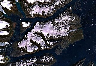
Milne Land or Milneland is a large island in eastern Greenland. It is the third largest island of Greenland, after the main island of Greenland and Disko Island. It is named after British admiral David Milne.

<span class="mw-page-title-main">Cape Hope</span>

Cape Hope is a headland in the Scoresby Sound, east Greenland, Sermersooq municipality.

Liverpool Land is a peninsula in eastern Greenland.

Rode Fjord is a fjord in King Christian X Land, eastern Greenland. The Rode Fjord is part of the Scoresby Sound complex in the area of Sermersooq municipality.

Rype Fjord is a fjord in King Christian X Land, eastern Greenland. This fjord is part of the Scoresby Sound system in the area of Sermersooq municipality.

<span class="mw-page-title-main">Scoresby Land</span> Region in Northeast Greenland National Park and Sermersooq, Greenland

Scoresby Land is an area of Eastern Greenland, which lies partly in Sermersooq and partly in the Northeast Greenland National Park zone. The area is uninhabited, except for Mestersvig, a military outpost.

<span class="mw-page-title-main">Nordvestfjord</span> Fjord in Greenland

Nordvestfjord, meaning 'Northwest Fjord', is a fjord in King Christian X Land, eastern Greenland.

<span class="mw-page-title-main">Ofjord</span> Fjord in eastern Greenland

Ofjord is a fjord in King Christian X Land, eastern Greenland. This fjord is part of the Scoresby Sound system. Administratively it lies in the area of Sermersooq municipality.

<span class="mw-page-title-main">Gaasefjord</span>

Gaasefjord is a fjord in King Christian X Land, eastern Greenland. This fjord is part of the Scoresby Sound system. Administratively it lies in the area of Sermersooq municipality.

<span class="mw-page-title-main">Dijmphna Sound</span> Strait in Greenland

The Dijmphna Sound is a sound in King Frederick VIII Land, Northeast Greenland. Administratively it is part of the Northeast Greenland National Park zone.

<span class="mw-page-title-main">Fonfjord</span>

Fonfjord is a fjord in King Christian X Land, eastern Greenland. This fjord is part of the Scoresby Sound system. Administratively it lies in the area of Sermersooq municipality.

Segelsällskapet Fjord is a fjord in King Christian X Land, eastern Greenland.

Kempe Fjord is a fjord in King Christian X Land, eastern Greenland.

<span class="mw-page-title-main">Carlsberg Fjord</span>

Carlsberg Fjord is a fjord in King Christian X Land, eastern Greenland.

<span class="mw-page-title-main">Davy Sound</span>

The Davy Sound is a sound in King Christian X Land, Northeast Greenland. Administratively it is part of the Northeast Greenland National Park zone.

<span class="mw-page-title-main">Young Sound</span> Sound in Greenland

Young Sound is a marine channel with a fjord structure in King Christian X Land, East Greenland. Administratively it is part of the Northeast Greenland National Park zone.

<span class="mw-page-title-main">Tyrolerfjord</span>

Tyrolerfjord is a fjord in King Christian X Land, East Greenland. Administratively it is part of the Northeast Greenland National Park zone.

<span class="mw-page-title-main">Conger Sound</span>

Conger Sound, also known as Conger Inlet, is a fjord in Peary Land, far northern Greenland.

References

  1. Prostar Sailing Directions 2005 Greenland and Iceland Enroute, p. 116
  2. Hanne Tuborg Sandell, Birger Sandell, Archaeology and Environment in the Scoresby Sund Fjord, p. 120
  3. 1 2 Place names, NE Greenland
  4. 1 2 "Hurry Inlet". Mapcarta. Retrieved 8 August 2019.