
Salal Dam, also known as Salal Hydroelectric Power Station, is a run-of-the-river hydropower project on the Chenab River in the Reasi district of the Jammu and Kashmir. It was the first hydropower project built by India in Jammu and Kashmir under the Indus Water Treaty regime. After having reached a bilateral agreement with Pakistan in 1978, with significant concessions made to Pakistan in the design of the dam, reducing its height, eliminating operating pool, and plugging the under-sluices meant for sediment management, India completed the project in 1987. The concessions made in the interest of bilateralism damaged the long-term sustainability of the dam, which silted up in five years. It currently runs at 57% capacity factor. Its long-term future is uncertain.

Ujjani Dam, also known as Bhima Dam or Bhima Irrigation Project, on the Bhima River, a tributary of the Krishna River, is an earthfill cum Masonry gravity dam located near Ujjani village of Madha Taluk in Solapur district of the state of Maharashtra in India.
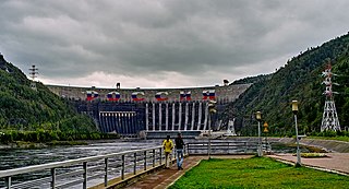
The Sayano-Shushenskaya Dam is located on the Yenisei River, near Sayanogorsk in Khakassia, Russia. It is the largest power plant in Russia and the 12th-largest hydroelectric plant in the world, by average power generation. The full legal name of the power plant, OJSC [Open Joint-Stock Society] P. S. Neporozhny Sayano-Shushenskaya HPP [hydro power plant], refers to the Soviet-time Minister of Energy and Electrification Pyotr Neporozhny. As of 2009 the head of the power plant was Valery Kyari.

The Darbandikhan Dam is a multi-purpose embankment dam on the Diyala River in northern Sulaymaniyah Governorate, Iraq. It was constructed between 1956 and 1961. The purpose of the dam is irrigation, flood control, hydroelectric power production and recreation. Due to poor construction and neglect, the dam and its 249 MW power station have undergone several repairs over the years. A rehabilitation of the power station began in 2007 and was completed in 2013.

The Fengman Dam is a concrete gravity dam 20 km (12 mi) from Jilin City on the Second Songhua River in Jilin Province, China. The main purposes of the dam are hydroelectric power generation and flood control. Construction of the dam began in 1937 and was complete in 1953. The dam is owned and operated by Northeast China Grid Company Limited.
The Jinanqiao Dam or Jin'anqiao Dam is a concrete gravity dam on the Jinsha River 25 km (16 mi) southeast of Lijiang City in Yunnan Province, China. The purpose of the dam is hydroelectric power production and flood control.
The Wanjiazhai Dam is a gravity dam on the Yellow River on the border of Pianguan County, Shaanxi Province and Inner Mongolia Autonomous Region, China. The main purpose of the dam is water supply for the Wanjiazhai Water Control Project along with peak hydroelectric power generation. Construction on the dam began in 1994, the first generator went online in 1998 and the last in 2000.
The Wujiangdu Dam is an arch-gravity dam on the Wu River south of Zunyi, Guizhou Province, China. The purpose of the dam is hydroelectric power generation, flood control and navigation. The dam's power stations contain five generators for a total installed capacity of 1,130 MW.

The Pensacola Dam, also known as the Grand River Dam, is a multiple-arch buttress dam located between the towns of Disney and Langley on the Grand River in Mayes County, Oklahoma. The dam is operated by the Grand River Dam Authority and creates Grand Lake o' the Cherokees. After decades of vision and planning, it was constructed between 1938 and 1940 for the purposes of hydroelectric power generation, flood control and recreation. It is Oklahoma's first hydroelectric power plant and is referred to as the longest multiple-arch dam in the world.

Ruskin Dam is a concrete gravity dam on the Stave River in Ruskin, British Columbia, Canada. The dam was completed in 1930 for the primary purpose of hydroelectric power generation. The dam created Hayward Lake, which supplies water to a 105 MW powerhouse and flooded the Stave's former lower canyon, which ended in a small waterfall approximately where the dam is today.

Stave Falls Dam is a dual-dam power complex on the Stave River in Stave Falls, British Columbia, Canada. The dam was completed in 1912 for the primary purpose of hydroelectric power production. To increase the capacity of Stave Lake, the dam was raised in 1925 and the Blind Slough Dam constructed in an adjacent watercourse 500 m (1,600 ft) to the north, which was the site of the eponymous Stave Falls. In 2000, the dam's powerhouse was replaced after a four-year upgrade. The original Stave Falls powerhouse was once British Columbia's largest hydroelectric power source, and is a National Historic Site of Canada.

Lake Cachi is an artificial lake in central Costa Rica created by the Cachí Dam, an arch dam north of Tapantí National Park, to the east-southeast of Cartago in Cartago Province. The main town is Cachí, away from the east bank of the lake. Built in the 1970s, it was one of the first hydroelectric projects in Costa Rica. It has an installed capacity of 102 MW with three units of 34 MW capacity each.

The Ramganga Dam, also known as the Kalagarh Dam, is an embankment dam on the Ramganga River 3 km (2 mi) upstream of Kalagarh in Pauri Garhwal district, Uttarakhand, India. It is located within the Jim Corbett National Park.
The Koteshwar Dam is a gravity dam on the Bhagirathi River, located 22 km (14 mi) downstream of the Tehri Dam in Tehri District, Uttarakhand, India. The dam is part of the Tehri Hydropower Complex and serves to regulate the Tehri Dam's tailrace for irrigation and create the lower reservoir of the Tehri Pumped Storage Power Station. In addition, the dam has a 400 MW run-of-the-river power station. The project was approved in 2000 and its first generator was commissioned on 27 March 2011, the second on 30 March 2011. The construction site had been inundated in September 2010 by floods. The diversion tunnel was later blocked heaving/collapse of the hill in December 2010. The spillway was commissioned in Jan, 2011. The last two generators were made operational in March 2012.

The Sup'ung Dam, also referred to as the Shuifeng Dam and originally the Suihō Dam, is a gravity dam on the Yalu River between Kuandian Manchu Autonomous County, Liaoning Province in China and Sakju County, North Pyongan Province in North Korea. The dam was constructed by the Japanese between 1937 and 1943 in order to generate electricity and has been repaired and renovated several times throughout the years, mainly due to spillway damage from flooding.
The Jinshuitan Dam is an arch dam on Longquan Creek, a tributary of the Oujiang River in Zhejiang Province, China. It is located about 47 km (29 mi) southwest of Lishui. The dam and power station were completed in 1988 and serve several purposes to include hydroelectric power generation, water supply, flood control and navigation. It is the first dam of the Oujiang River cascade to be constructed and creates the second largest lake in Zhejiang.
The Baozhusi Dam is a gravity dam on the Bailong River, located 23 km (14 mi) northwest of Guangyuan in Sichuan Province, China. Construction on the dam began in 1984, the generators were operational between 1996 and 1998 while the rest of the facilities were complete 2000. The dam was constructed for hydroelectric power generation, flood control and water supply for irrigation and industrial uses. The 132 m (433 ft) tall concrete gravity dam creates a 2,550,000,000 m3 (2,067,319 acre⋅ft) reservoir with a surface area of 61.2 km2 (24 sq mi). On either side of power station at the dam's base, there are two gate-controlled chute spillways. Beside them are two pairs of intermediate sluice-controlled orifice openings. Below the left intermediate opening are two bottom sluices. The total discharge capacity of the spillways and openings is 16,060 m3/s (567,154 cu ft/s). The dam's power station contains 4 x 175 MW Francis turbine-generators which are afford a maximum hydraulic head of 103 m (338 ft) given the dam's height.
The Guxian Dam is a concrete gravity dam on the Luo River, a tributary of the Yellow River, in Luoning County, Henan Province, China. The primary purpose of the dam is flood control but it also generates hydroelectricity and provides water for irrigation. The 125 m (410 ft) tall dam withholds a reservoir of 1,175,000,000 m3 (952,588 acre⋅ft) and provides 848,000,000 m3 (687,485 acre⋅ft) in flood storage. The dam's power station contains three 20 MW Francis turbine-generators for a total installed capacity of 60 MW. Construction on the dam began in 1958 but was suspended several times afterwards. It recommenced in 1978 and the reservoir began to fill in 1991. The dam's generators were commissioned in 1992 and the project complete in 1993. The dam's spillway is controlled by five tainter gates and has a maximum discharge capacity of 11,436 m3/s (403,859 cu ft/s). Flip buckets are used at the spillway base to dissipate water. On the right side of the spillway there are two intermediate orifice openings controlled by hydraulic press-operated radial gates. Two bottom outlets are set on the spillway's left side, also controlled by hydraulic press-operated radial gates. To the left of the bottom outlets is the power station.
The Huanglongtan Dam is a concrete gravity dam located on the Du River, a tributary of the Han River. It is located 25 km (16 mi) west of Shiyan in Hubei Province, China. The main purpose of the dam is hydroelectric power generation but it also provides for flood control. It was constructed between 1969 and 1976 and support a 510 MW power station.
The Unbong Dam, or Yunfeng Dam, is a concrete gravity dam on the Yalu River which borders China and North Korea. It is located 33 km (21 mi) northeast of Ji'an in Jilin Province, China and Chasŏng in Chagang Province, North Korea. The primary purpose of the dam is hydroelectric power generation and it supports a 400 MW power station. Construction of the dam had initially began in August 1942 but was halted in 1945 after the surrender of Japan ending World War II. In October 1959, construction on the dam recommenced and in September 1965, the first of the four 100 MW Francis turbine-generators was operational. The last generator was operational on 4 April 1967. The 113.75 m (373 ft) tall dam creates a reservoir with a storage capacity of 3,895,000,000 m3 (3,157,728 acre⋅ft). The dam's spillway is an overflow type with 21 floodgates and has a maximum discharge of 21,900 m3/s (773,391 cu ft/s). The dam is located before a bend in the river and its power station is located on the other side of a ridge that meets the dam's right abutment. Water is delivered to the power station via two tunnels, 775 m (2,543 ft) and 759 m (2,490 ft) long. Generators 1 and 3 deliver power to China while 2 and 4 deliver to North Korea.


