Älpelekopf is a mountain with an elevation of 1,606 m (5,269 ft) in the Alps. Älpelekopf has a secondary peak situated on a ridge which runs southwest from Riffenkopf to Schrofen at which point the ridge falls off steeply.

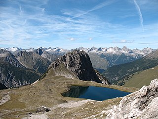
The Alpgundkopf is a mountain, 2,177 m high, in the Allgäu Alps. It lies in the Schafalpenköpfe group, northeast of the Roßgundkopf, from which it is separated by the Alpgundscharte col. To the southeast, 383 metres away, lies the lower Alpkopf and, 1,035 metres away, the small lake of Guggersee.

The Giebel is the northeastern corner of the mountain chain that branches off to the northeast at the Laufbacher Eck. It has a height of 1,949 metres and belongs to the Allgäu grass mountains. Northeast of the Giebel lies the Alpine hut of Giebelhaus, which may be reached on a road from Hinterstein that is not open to the public. From the Giebel there are impressive views down to the Giebelhaus.

The Hochfrottspitze is a 2,649-metre-high (8,691 ft) mountain, made of main dolomite, in the Allgäu Alps near Oberstdorf in Germany and the highest German mountain in the Allgäu Alps. The border with Austria runs along its ridge.
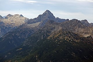
The Hochvogel is a 2,592-metre-high (8,504 ft) mountain in the Allgäu Alps. The national border between Germany and Austria runs over the summit. Although only the thirteenth highest summit in the Allgäu Alps, the Hochvogel dominates other parts of Allgäu Alps and the other ranges in the immediate neighbourhood. This is due to the fact that the majority of the higher peaks are concentrated in the central and western part of the Allgäu Alps. The Hochvogel stands on its own in the eastern part of the mountain group; the nearest neighbouring summits are 200 to 300 metres lower. Experienced climbers can ascend the summit on two marked routes.

The Krottenspitze (2,551m) is a mountain in the Allgäu Alps. It is one of the few rocky summits of the main ridge that is visible from Oberstdorf.

The Laufbacher Eck is a 2,178-metre-high grass mountain in the Allgäu Alps in the south German state of Bavaria.

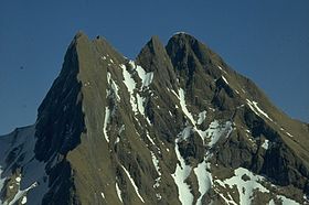
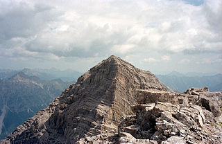
The Mädelegabel is a 2,645 metre high mountain, made of main dolomite, in the Allgäu Alps near Oberstdorf. It is one of the best-known and most-climbed high peaks in the German Alps, Within the Allgäu Alps it is the fourth-highest summit, with rock faces up to 400 metres high. Together with the Trettachspitze and the Hochfrottspitze it forms the famous triumvirate of peaks on the main crest of the Allgäu. Its name comes from Mähder - a mown mountain pasture in the vicinity - and gabel from the appearance of the triumvirate to the north which recalls a fork. Originally the Mädelegabel was the name for all three peaks of the triumvirate; only later were they distinguished from one another by name.

Mußkopf is a mountain in the Allgäu Alps which are located in Bavaria, Germany. It is a peak above a steep couloir, below the Rappensee Hut alpine hut. There is no marked trail to the peak.

The Öfnerspitze is a 2,576 m high, rocky mountain in the Allgäu Alps.

The Trettachspitze is a 2,595-metre-high (8,514 ft) mountain in the Allgäu Alps in Germany. Due to its striking appearance it is one of the best-known mountains in the Allgäu Alps.

The Salober ist a 2,088 -high grass mountain in the Allgäu Alps. It lies northeast of the Laufbacher Eck.
The First Schafalpenkopf or Southwestern Schafalpenkopf is a 2,272-metre-high mountain in the Allgäu Alps. It is part of the Schafalpenköpfe and the Mindelheim Klettersteig.
The Urbeleskarspitze is a 2,632-metre-high mountain peak in the Allgäu Alps. It lies within Austria in the state of Tyrol and is the fifth-highest summit in the Allgäu Alps and the second-highest peak in the Hornbach chain. Its neighbours in the Hornbach chain are the Bretterspitze to the southwest and the Zwölfer Spitze to the northeast.
The Hornbach chain is a string of mountains, about 15 kilometres long, in the Allgäu Alps in the Austrian state of Tyrol.

The Großer Widderstein is a mountain, 2,533 m (AA), in the west Austrian state of Vorarlberg. Topographically it belongs to the Allgäu Alps. It is the highest peak in the subgroup of the Southeastern Walsertal Mountains.

The Sigiswanger Horn is part of the Hörner group in the Allgäu Alps. It reaches a height of 1,527 m and rises between Bolsterlang and Ofterschwang. Like its neighbour, the Rangiswanger Horn, it belongs geologically to the flysch mountains of the Anterior Hörner group, with their numerous boggy meadows and species-rich forested ravines.

The Kreuzkarspitze is a 2,587-metre-high Austrian mountain in the Hornbach chain of the Allgäu Alps.

The Weiherkopf is a summit in the Hörner Group within the Allgäu Alps in Bavaria, Germany, with a height of 1,665 m.