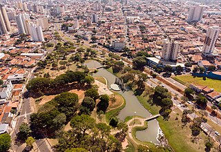
Bauru is a Brazilian municipality in midwestern region of the state of São Paulo. It is the main city of the mesoregion and microregion of Bauru. The population is 379,297 in an area of 667.68 km2. Established in 1896, its boundaries are Reginópolis to the north, Arealva to the northeast, Pederneiras to the east, Agudos and Piratininga to the south and Avaí to the west.

Ibirá is a municipality in the state of São Paulo, Brazil. The population is 12,518 in an area of 190 km². Ibirá is known as a tourist resort, due to the thermal waters.

Icém is a municipality in the northern part of the state of São Paulo in Brazil. The population is 8,304 in an area of 362.59 km². It is part of the Microregion of São José do Rio Preto. It is also known as Princesa do Vale, or "Princess of the Valley." Icem is situated near the important urban centers of São José do Rio Preto, Olímpia, Catanduva, and Mirassol. The Marimbondo Dam, which forms a big reservoir in the Rio Grande, is situated close to Icém.

Igaraçu do Tietê is a municipality in the state of São Paulo in Brazil. The population is 24,749 in an area of 97.7 km². The elevation is 498 m.

Ilha Solteira is a municipality in the state of São Paulo in Brazil. The population is 26,788 in an area of 653 km². The elevation is 335 m. The nearby Ilha Solteira Dam created a reservoir in the Paraná River.

Itu is a historic municipality in the state of São Paulo in Brazil. It is part of the Metropolitan Region of Sorocaba. The population was 175,568 as of 2020, in an area of 640.72 km2. The elevation is 583 m. This place name comes from the Tupi language, meaning big waterfall. Two rivers flow through Itu: Tietê and Jundiaí. Itu has five hospitals, eleven bank agencies and one shopping center, the Plaza Shopping Itu.

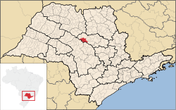
Mineiros do Tietê is a municipality in the state of São Paulo in Brazil. The population is 12,966 in an area of 213 km2 (82 sq mi). It is situated in the center of the state of São Paulo, near the following cities: Dois Córregos (9 km), Barra Bonita (13 km), Jaú (18 km), São Manuel (45 km), Torrinha (35 km), Igaraçu do Tietê (15 km), Lençois Paulista (46 km), Pederneiras (45 km) and Bauru (82 km). It is located at an altitude of 669 meters, near the Tietê River.
Paraibuna is a municipality (município) in the state of São Paulo in Brazil. It is part of the Metropolitan Region of Vale do Paraíba e Litoral Norte. The population is 18,263 in an area of 809.58 km². The elevation is 635 m. The SP-99 highway passes through the town.

Pederneiras is a municipality in the state of São Paulo in Brazil. The population is 47,111 in an area of 729 km². The elevation is 475 m above sea level.

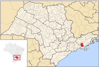
Pedreira is a municipality in the state of São Paulo in Brazil. It is part of the Metropolitan Region of Campinas. The population is 48,463 in an area of 108.82 km². The elevation is 590 m. The town is located 138 km from the capital. It is called "Flor da Porcelana" because of its porcelain related commerce. Pedreira was founded in 1896. It is linearly distributed on Jaguari River banks. The name of the town comes from the name "Pedro", present in the most male members of the founder's family, Colonel João Pedro de Godoy Moreira. Pedreira offers as main attraction its large porcelain, glasses, wood crafts, aluminium, decoration pieces commerce, with shops especialized in tourist service.

Penápolis is a municipality in the state of São Paulo, Brazil. The population is of 63,757 inhabitants (IBGE/2020). The city has an area of 710.8 km².

Cabreúva is a municipality (município) in the state of São Paulo in Brazil. The population is 50,429 in an area of 260.23 km2. The elevation is 640 m. The city takes its name from the Cabreúva tree, known as Kaburé-Iwa in Tupi language.

Queluz is a municipality in the state of São Paulo in Brazil. It is part of the Metropolitan Region of Vale do Paraíba e Litoral Norte.

The Tietê River is a Brazilian river in the state of São Paulo.

Salesópolis is a municipality in the state of São Paulo in Brazil. It is part of the Metropolitan Region of São Paulo. The population is 17,252 in an area of 424.997 km². Salesópolis sits at an elevation of 850 metres (2,790 ft). It is noted for being the source of the Tietê River.

Brotas is a Brazilian municipality located in the state of São Paulo. The population is 24,636 in an area of 1101 km2. The town is known locally for its coffee, on which its economy relies.
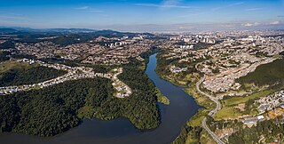
Santana de Parnaíba is a city and municipality in the state of São Paulo in Brazil. It is part of the Metropolitan Region of São Paulo. The population is 142,301 in an area of 179.95 km2 (69.48 sq mi). It was founded in 1625 near the Tietê River by Susana Dias, an important Bandeirante wife. It was the birthplace of prominent Bandeirante Domingos Jorge Velho, and of Warwick Estevam Kerr.

Salto is a municipality in the state of São Paulo in Brazil. It is part of the Metropolitan Region of Sorocaba. The population is 119,736 in an area of 133.06 km². The elevation is 555 m. The city has one main river, rio Tietê. The city has an important geological park, the Moutonée Park.

Tietê is a Brazilian municipality in the state of São Paulo, located in the Metropolitan Region of Sorocaba, in the Meso-region of Piracicaba and in the Microregion of Piracicaba. It is located at latitude 23º06'07 "south and at a longitude 47º42'53" west, being at an altitude of 508 meters. Its estimated population in 2020 was 42,517 inhabitants. It has an area of 392,509 km2. This corresponds to a population density of 86.6 inhabitants/km2.
The Jacaré-Guaçu River is a river of São Paulo state in southeastern Brazil. It flows into the Tietê River near Ibitinga.