Ice-sheet dynamics

Last updated

Glacial flow rate in the Antarctic ice sheet. Antarctica glacier flow rate.jpg
Glacial flow rate in the Antarctic ice sheet.
The motion of ice in Antarctica

Ice sheet dynamics describe the motion within large bodies of ice such as those currently on Greenland and Antarctica. Ice motion is dominated by the movement of glaciers, whose gravity-driven activity is controlled by two main variable factors: the temperature and the strength of their bases. A number of processes alter these two factors, resulting in cyclic surges of activity interspersed with longer periods of inactivity, on both hourly and centennial time scales. Ice-sheet dynamics are of interest in modelling future sea level rise.

Contents

Animation showing glacier changes.
This animation shows the average yearly change in mass, in cm of water, during 2003–2010, over the Indian subcontinent. The yellow circles mark locations of glaciers. There is significant mass loss in this region (denoted by the blue and purple colors), but it is concentrated over the plains south of the glaciers, and is caused by groundwater depletion. A color-bar overlay shows the range of values displayed.

General

Boundary conditions

The interface between an ice stream and the ocean is a significant control of the rate of flow.

The collapse of the Larsen B ice shelf had profound effects on the velocities of its feeder glaciers. Larsen B collapse.jpg
The collapse of the Larsen B ice shelf had profound effects on the velocities of its feeder glaciers.

Ice shelves are thick layers of ice floating on the sea – can stabilise the glaciers that feed them. These tend to have accumulation on their tops, may experience melting on their bases, and calve icebergs at their periphery. The catastrophic collapse of the Larsen B ice shelf in the space of three weeks during February 2002 yielded some unexpected observations. The glaciers that had fed the ice sheet (Crane, Jorum, Green, Hektoria – see image) increased substantially in velocity. This cannot have been due to seasonal variability, as glaciers flowing into the remnants of the ice shelf (Flask, Leppard) did not accelerate. [1]

Ice shelves exert a dominant control in Antarctica, but are less important in Greenland, where the ice sheet meets the sea in fjords. Here, melting is the dominant ice removal process, [2] resulting in predominant mass loss occurring towards the edges of the ice sheet, where icebergs are calved in the fjords and surface meltwater runs into the ocean.

Tidal effects are also important; the influence of a 1 m tidal oscillation can be felt as much as 100 km from the sea. [3] On an hour-to-hour basis, surges of ice motion can be modulated by tidal activity. During larger spring tides, an ice stream will remain almost stationary for hours at a time, before a surge of around a foot in under an hour, just after the peak high tide; a stationary period then takes hold until another surge towards the middle or end of the falling tide. [4] [5] At neap tides, this interaction is less pronounced, without tides surges would occur more randomly, approximately every 12 hours. [4]

Ice shelves are also sensitive to basal melting. In Antarctica, this is driven by heat fed to the shelf by the circumpolar deep water current, which is 3 °C above the ice's melting point. [6]

As well as heat, the sea can also exchange salt with the oceans. The effect of latent heat, resulting from melting of ice or freezing of sea water, also has a role to play. The effects of these, and variability in snowfall and base sea level combined, account for around 80 mm annual variability in ice shelf thickness.

Long-term changes

Over long time scales, ice sheet mass balance is governed by the amount of sunlight reaching the Earth. This variation in sunlight reaching the Earth, or insolation, over geologic time is in turn determined by the angle of the Earth to the Sun and shape of the Earth's orbit, as it is pulled on by neighboring planets; these variations occur in predictable patterns called Milankovitch cycles. Milankovitch cycles dominate climate on the glacial–interglacial timescale, but there exist variations in ice sheet extent that are not linked directly with insolation.

For instance, during at least the last 100,000 years, portions of the ice sheet covering much of North America, the Laurentide Ice Sheet broke apart sending large flotillas of icebergs into the North Atlantic. When these icebergs melted they dropped the boulders and other continental rocks they carried, leaving layers known as ice rafted debris. These so-called Heinrich events, named after their discoverer Hartmut Heinrich, appear to have a 7,000–10,000-year periodicity, and occur during cold periods within the last interglacial. [7]

Internal ice sheet "binge-purge" cycles may be responsible for the observed effects, where the ice builds to unstable levels, then a portion of the ice sheet collapses. External factors might also play a role in forcing ice sheets. Dansgaard–Oeschger events are abrupt warmings of the northern hemisphere occurring over the space of perhaps 40 years. While these D–O events occur directly after each Heinrich event, they also occur more frequently – around every 1500 years; from this evidence, paleoclimatologists surmise that the same forcings may drive both Heinrich and D–O events. [8]

Hemispheric asynchrony in ice sheet behavior has been observed by linking short-term spikes of methane in Greenland ice cores and Antarctic ice cores. During Dansgaard–Oeschger events, the northern hemisphere warmed considerably, dramatically increasing the release of methane from wetlands, that were otherwise tundra during glacial times. This methane quickly distributes evenly across the globe, becoming incorporated in Antarctic and Greenland ice. With this tie, paleoclimatologists have been able to say that the ice sheets on Greenland only began to warm after the Antarctic ice sheet had been warming for several thousand years. Why this pattern occurs is still open for debate. [9] [10]

Glaciers

Flow dynamics

Aerial photograph of the Gorner Glacier (l.) and the Grenzgletscher (r.) flowing (in the image downwards) around the Monte Rosa massif (middle) in the Swiss Alps Aerial Photo of Monte Rosa Massif - Wallis - Switzerland (cropped).jpg
Aerial photograph of the Gorner Glacier (l.) and the Grenzgletscher (r.) flowing (in the image downwards) around the Monte Rosa massif (middle) in the Swiss Alps
The stress-strain relationship of plastic flow (teal section): a small increase in stress creates an exponentially greater increase in strain, which equates to deformation speed. Stress-strain1.svg
The stress–strain relationship of plastic flow (teal section): a small increase in stress creates an exponentially greater increase in strain, which equates to deformation speed.

The main cause of flow within glaciers can be attributed to an increase in the surface slope, brought upon by an imbalance between the amounts of accumulation vs. ablation. This imbalance increases the shear stress on a glacier until it begins to flow. The flow velocity and deformation will increase as the equilibrium line between these two processes is approached, but are also affected by the slope of the ice, the ice thickness and temperature. [11] [12]

When the amount of strain (deformation) is proportional to the stress being applied, ice will act as an elastic solid. Ice will not flow until it has reached a thickness of 30 meters (98 ft), but after 50 meters (164 ft), small amounts of stress can result in a large amount of strain, causing the deformation to become a plastic flow rather than elastic. At this point the glacier will begin to deform under its own weight and flow across the landscape. According to the Glen–Nye flow law, the relationship between stress and strain, and thus the rate of internal flow, can be modeled as follows: [11] [12]

where:

= shear strain (flow) rate
= stress
= a constant between 2–4 (typically 3 for most glaciers) that increases with lower temperature
= a temperature-dependent constant

The lowest velocities are near the base of the glacier and along valley sides where friction acts against flow, causing the most deformation. Velocity increases inward toward the center line and upward, as the amount of deformation decreases. The highest flow velocities are found at the surface, representing the sum of the velocities of all the layers below. [11] [12]

Glaciers may also move by basal sliding, where the base of the glacier is lubricated by meltwater, allowing the glacier to slide over the terrain on which it sits. Meltwater may be produced by pressure-induced melting, friction or geothermal heat. The more variable the amount of melting at surface of the glacier, the faster the ice will flow. [13]

The top 50 meters of the glacier form the fracture zone, where ice moves as a single unit. Cracks form as the glacier moves over irregular terrain, which may penetrate the full depth of the fracture zone.

Subglacial processes

A cross-section through a glacier. The base of the glacier is more transparent as a result of melting. Glacier cross-section.jpg
A cross-section through a glacier. The base of the glacier is more transparent as a result of melting.

Most of the important processes controlling glacial motion occur in the ice-bed contact—even though it is only a few meters thick. [3] Glaciers will move by sliding when the basal shear stress drops below the shear resulting from the glacier's weight.[ clarification needed ]

τD = ρgh sin α
where τD is the driving stress, and α the ice surface slope in radians. [3]
τB is the basal shear stress, a function of bed temperature and softness. [3]
τF, the shear stress, is the lower of τB and τD. It controls the rate of plastic flow, as per the figure (inset, right).

For a given glacier, the two variables are τD, which varies with h, the depth of the glacier, and τB, the basal shear stress.[ clarification needed ]

Basal shear stress

The basal shear stress is a function of three factors: the bed's temperature, roughness and softness. [3]

Whether a bed is hard or soft depends on the porosity and pore pressure; higher porosity decreases the sediment strength (thus increases the shear stress τB). [3] If the sediment strength falls far below τD, movement of the glacier will be accommodated by motion in the sediments, as opposed to sliding. Porosity may vary through a range of methods.

  • Movement of the overlying glacier may cause the bed to undergo dilatancy; the resulting shape change reorganises blocks. This reorganises closely packed blocks (a little like neatly folded, tightly packed clothes in a suitcase) into a messy jumble (just as clothes never fit back in when thrown in in a disordered fashion). This increases the porosity. Unless water is added, this will necessarily reduce the pore pressure (as the pore fluids have more space to occupy). [3]
  • Pressure may cause compaction and consolidation of underlying sediments. [3] Since water is relatively incompressible, this is easier when the pore space is filled with vapour; any water must be removed to permit compression. In soils, this is an irreversible process. [3]
  • Sediment degradation by abrasion and fracture decreases the size of particles, which tends to decrease pore space, although the motion of the particles may disorder the sediment, with the opposite effect. [3] These processes also generate heat, whose importance will be discussed later.
Factors controlling the flow of ice Ice flow controls.jpg
Factors controlling the flow of ice

A soft bed, with high porosity and low pore fluid pressure, allows the glacier to move by sediment sliding: the base of the glacier may even remain frozen to the bed, where the underlying sediment slips underneath it like a tube of toothpaste. A hard bed cannot deform in this way; therefore the only way for hard-based glaciers to move is by basal sliding, where meltwater forms between the ice and the bed itself. [14]

Bed softness may vary in space or time, and changes dramatically from glacier to glacier. An important factor is the underlying geology; glacial speeds tend to differ more when they change bedrock than when the gradient changes. [14]

As well as affecting the sediment stress, fluid pressure (pw) can affect the friction between the glacier and the bed. High fluid pressure provides a buoyancy force upwards on the glacier, reducing the friction at its base. The fluid pressure is compared to the ice overburden pressure, pi, given by ρgh. Under fast-flowing ice streams, these two pressures will be approximately equal, with an effective pressure (pi – pw) of 30 kPa; i.e. all of the weight of the ice is supported by the underlying water, and the glacier is afloat. [3]

Basal melt

A number of factors can affect bed temperature, which is intimately associated with basal meltwater. The melting point of water decreases under pressure, meaning that water melts at a lower temperature under thicker glaciers. [3] This acts as a "double whammy", because thicker glaciers have a lower heat conductance, meaning that the basal temperature is also likely to be higher. [14]

Bed temperature tends to vary in a cyclic fashion. A cool bed has a high strength, reducing the speed of the glacier. This increases the rate of accumulation, since newly fallen snow is not transported away. Consequently, the glacier thickens, with three consequences: firstly, the bed is better insulated, allowing greater retention of geothermal heat. Secondly, the increased pressure can facilitate melting. Most importantly, τD is increased. These factors will combine to accelerate the glacier. As friction increases with the square of velocity, faster motion will greatly increase frictional heating, with ensuing melting – which causes a positive feedback, increasing ice speed to a faster flow rate still: west Antarctic glaciers are known to reach velocities of up to a kilometre per year. [3] Eventually, the ice will be surging fast enough that it begins to thin, as accumulation cannot keep up with the transport. This thinning will increase the conductive heat loss, slowing the glacier and causing freezing. This freezing will slow the glacier further, often until it is stationary, whence the cycle can begin again. [14]

Supraglacial lakes represent another possible supply of liquid water to the base of glaciers, so they can play an important role in accelerating glacial motion. Lakes of a diameter greater than ~300 m are capable of creating a fluid-filled crevasse to the glacier/bed interface. When these crevasses form, the entirety of the lake's (relatively warm) contents can reach the base of the glacier in as little as 2–18 hours – lubricating the bed and causing the glacier to surge. [15] Water that reaches the bed of a glacier may freeze there, increasing the thickness of the glacier by pushing it up from below. [16]

Finally, bed roughness can act to slow glacial motion. The roughness of the bed is a measure of how many boulders and obstacles protrude into the overlying ice. Ice flows around these obstacles by melting under the high pressure on their stoss side; the resultant meltwater is then forced into the cavity arising in their lee side, where it re-freezes. [3]

Pipe and sheet flow

The flow of water under the glacial surface can have a large effect on the motion of the glacier itself. Subglacial lakes contain significant amounts of water, which can move fast: cubic kilometres can be transported between lakes over the course of a couple of years. [17]

This motion is thought to occur in two main modes: pipe flow involves liquid water moving through pipe-like conduits, like a sub-glacial river; sheet flow involves motion of water in a thin layer. A switch between the two flow conditions may be associated with surging behaviour. Indeed, the loss of sub-glacial water supply has been linked with the shut-down of ice movement in the Kamb ice stream. [17] The subglacial motion of water is expressed in the surface topography of ice sheets, which slump down into vacated subglacial lakes. [17]

Effects

Climate change

Rates of ice-sheet thinning in Greenland (2003). Greenland ice sheet thinning rate.png
Rates of ice-sheet thinning in Greenland (2003).

The implications of the current climate change on ice sheets are difficult to ascertain. It is clear that increasing temperatures are resulting in reduced ice volumes globally. [2] (Due to increased precipitation, the mass of parts of the Antarctic ice sheet may currently be increasing, but the total mass balance is unclear. [2] )

Rising sea levels will reduce the stability of ice shelves, which have a key role in reducing glacial motion. Some Antarctic ice shelves are currently thinning by tens of metres per year, and the collapse of the Larsen B shelf was preceded by thinning of just 1 metre per year. [2] Further, increased ocean temperatures of 1 °C may lead to up to 10 metres per year of basal melting. [2] Ice shelves are always stable under mean annual temperatures of −9 °C, but never stable above −5 °C; this places regional warming of 1.5 °C, as preceded the collapse of Larsen B, in context. [2]

Differential erosion enhances relief, as clear in this incredibly steep-sided Norwegian fjord. Geirangerfjord (6-2007).jpg
Differential erosion enhances relief, as clear in this incredibly steep-sided Norwegian fjord.

Increasing global air temperatures take around 10,000 years to directly propagate through the ice before they influence bed temperatures, but may have an effect through increased surfacal melting, producing more supraglacial lakes, which may feed warm water to glacial bases and facilitate glacial motion. [2] In areas of increased precipitation, such as Antarctica, the addition of mass will increase rate of glacial motion, hence the turnover in the ice sheet. Observations, while currently limited in scope, do agree with these predictions of an increasing rate of ice loss from both Greenland and Antarctica. [2] A possible positive feedback may result from shrinking ice caps, in volcanically active Iceland at least. Isostatic rebound may lead to increased volcanic activity, causing basal warming – and, through CO2 release, further climate change. [18]

Cold meltwater provides cooling of the ocean's surface layer, acting like a lid, and also affecting deeper waters by increasing subsurface ocean warming and thus facilitating ice melt.

Our "pure freshwater" experiments show that the low-density lid causes deep-ocean warming, especially at depths of ice shelf grounding lines that provide most of the restraining force limiting ice sheet discharge. [19]

Erosion

Because ice can flow faster where it is thicker, the rate of glacier-induced erosion is directly proportional to the thickness of overlying ice. Consequently, pre-glacial low hollows will be deepened and pre-existing topography will be amplified by glacial action, while nunataks, which protrude above ice sheets, barely erode at all – erosion has been estimated as 5 m per 1.2 million years. [20] This explains, for example, the deep profile of fjords, which can reach a kilometer in depth as ice is topographically steered into them. The extension of fjords inland increases the rate of ice sheet thinning since they are the principal conduits for draining ice sheets. It also makes the ice sheets more sensitive to changes in climate and the ocean. [20]

Marine ice sheet instability

A collage of footage and animation to explain the changes that are occurring on the West Antarctic Ice Sheet, narrated by glaciologist Eric Rignot

Marine ice sheet instability (MISI) describes the potential for ice sheets grounded below sea level to destabilize in a runaway fashion. The mechanism was first proposed in the 1970s [21] [22] by Johannes Weertman and was quickly identified as a means by which even gradual anthropogenic warming could lead to relatively rapid sea level rise. [23] [24] In Antarctica, the West Antarctic Ice Sheet, the Aurora Subglacial Basin, and the Wilkes Basin are each grounded below sea level and are inherently subject to MISI.

The term marine ice sheet describes an ice sheet whose base rests on ground below sea level, and marine ice sheet instability describes the inherent precarious nature of marine ice sheets due to Archimedes' principle. Because seawater is denser than ice, marine ice sheets can only remain stable where the ice is thick enough for its mass to exceed the mass of the seawater displaced by the ice. In other words, wherever ice exists below sea level, it is held in place only by the weight of overlying ice. As a marine ice sheet melts, the weight of the overlying ice decreases. If melt causes thinning beyond a critical threshold, the overlying ice may no longer be heavy enough to prevent the submarine ice below it from lifting off the ground, allowing water to penetrate underneath.

The location of the grounding line, the boundary between the ice sheet and the floating ice shelves, is unstable in this case. The amount of ice flowing over the grounding line initially matches the production of ice from snow upstream. When the grounding line is pushed backwards, due to for instance melt by warm water, the ice sheet is thicker at the new location of the grounding line and the total amount of ice flowing through may increase. (This depends on the slope of the subaerial surface.) As this causes the ice sheet to lose mass, the grounding line is pushed back even further and this self-reinforcing mechanism is the cause of the instability. Ice sheets of this type have accelerated ice sheet retreat. [25] [26]

Strictly speaking the MISI theory is only valid if the ice shelves are free floating and not constrained in an embayment. [27]

The initial perturbation or push-back of the grounding line might be caused by high water temperatures at the base of ice shelves so that melt increases (basal melt). The thinned ice shelves, which earlier stabilized the ice sheet, exert less of an buttressing effect (back stress). [25]

Marine Ice Cliff Instability

A related process known as Marine Ice Cliff Instability (MICI) posits that due to the physical characteristics of ice, subaerial ice cliffs exceeding ~90 meters in height are likely to collapse under their own weight, and could lead to runaway ice sheet retreat in a fashion similar to MISI. [25] For an ice sheet grounded below sea level with an inland-sloping bed, ice cliff failure removes peripheral ice, which then exposes taller, more unstable ice cliffs, further perpetuating the cycle of ice front failure and retreat. Surface melt can further enhance MICI through ponding and hydrofracture. [27] [28]

Ocean warming

Schematic of stratification and precipitation amplifying feedbacks. Stratification: increased freshwater flux reduces surface water density, thus reducing AABW formation, trapping NADW heat, and increasing ice shelf melt. Precipitation: increased freshwater flux cools ocean mixed layer, increases sea ice area, causing precipitation to fall before it reaches Antarctica, reducing ice sheet growth and increasing ocean surface freshening. Ice in West Antarctica and the Wilkes Basin, East Antarctica, is most vulnerable because of the instability of retrograde beds. Schematic-of-stratification-and-precipitation-amplifying-feedbacks.jpg
Schematic of stratification and precipitation amplifying feedbacks. Stratification: increased freshwater flux reduces surface water density, thus reducing AABW formation, trapping NADW heat, and increasing ice shelf melt. Precipitation: increased freshwater flux cools ocean mixed layer, increases sea ice area, causing precipitation to fall before it reaches Antarctica, reducing ice sheet growth and increasing ocean surface freshening. Ice in West Antarctica and the Wilkes Basin, East Antarctica, is most vulnerable because of the instability of retrograde beds.

According to a 2016 published study, cold meltwater provides cooling of the ocean's surface layer, acting like a lid, and also affecting deeper waters by increasing subsurface ocean warming and thus facilitating ice melt.

Our "pure freshwater" experiments show that the low-density lid causes deep-ocean warming, especially at depths of ice shelf grounding lines that provide most of the restraining force limiting ice sheet discharge. [19]

Another theory discussed in 2007 for increasing warm bottom water is that changes in air circulation patterns have led to increased upwelling of warm, deep ocean water along the coast of Antarctica and that this warm water has increased melting of floating ice shelves. [29] An ocean model has shown how changes in winds can help channel the water along deep troughs on the sea floor, toward the ice shelves of outlet glaciers. [30]

Observations

In West Antarctica, the Thwaites and Pine Island glaciers have been identified to be potentially prone to MISI, and both glaciers have been rapidly thinning and accelerating in recent decades. [31] [32] [33] [34] In East Antarctica, Totten Glacier is the largest glacier known to be subject to MISI, [35] and its potential contribution to sea level rise is comparable to that of the entire West Antarctic Ice Sheet. Totten Glacier has been losing mass nearly monotonically in recent decades, [36] suggesting rapid retreat is possible in the near future, although the dynamic behavior of Totten Ice Shelf is known to vary on seasonal to interannual timescales. [37] [38] [39] The Wilkes Basin is the only major submarine basin in Antarctica that is not thought to be sensitive to warming. [33]

In October 2023, a study published in Nature Climate Change projected that ocean warming at about triple the historical rate is likely unavoidable in the 21st century, with no significant difference between mid-range emissions scenarios versus achieving the most ambitious targets of the Paris Agreement—suggesting that greenhouse gas mitigation has limited ability to prevent collapse of the West Antarctic Ice Sheet. [40]

See also

Related Research Articles

<span class="mw-page-title-main">Glacier</span> Persistent body of ice that is moving under its own weight

A glacier is a persistent body of dense ice that is constantly moving under its own weight. A glacier forms where the accumulation of snow exceeds its ablation over many years, often centuries. It acquires distinguishing features, such as crevasses and seracs, as it slowly flows and deforms under stresses induced by its weight. As it moves, it abrades rock and debris from its substrate to create landforms such as cirques, moraines, or fjords. Although a glacier may flow into a body of water, it forms only on land and is distinct from the much thinner sea ice and lake ice that form on the surface of bodies of water.

<span class="mw-page-title-main">Climate of Antarctica</span> Overview of climactic conditions in Antarctica

The climate of Antarctica is the coldest on Earth. The continent is also extremely dry, averaging 166 mm (6.5 in) of precipitation per year. Snow rarely melts on most parts of the continent, and, after being compressed, becomes the glacier ice that makes up the ice sheet. Weather fronts rarely penetrate far into the continent, because of the katabatic winds. Most of Antarctica has an ice-cap climate with extremely cold and dry weather.

<span class="mw-page-title-main">Ice shelf</span> Large floating platform of ice caused by glacier flowing onto ocean surface

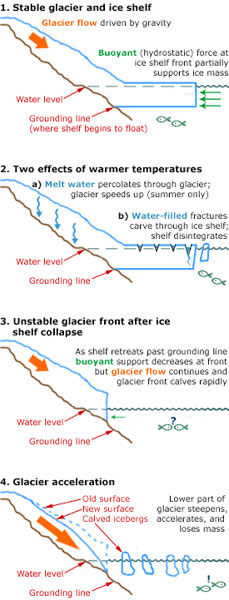
An ice shelf is a large platform of glacial ice floating on the ocean, fed by one or multiple tributary glaciers. Ice shelves form along coastlines where the ice thickness is insufficient to displace the more dense surrounding ocean water. The boundary between the ice shelf (floating) and grounded ice is referred to as the grounding line; the boundary between the ice shelf and the open ocean is the ice front or calving front.

<span class="mw-page-title-main">Ice sheet</span> Large mass of glacial ice

In glaciology, an ice sheet, also known as a continental glacier, is a mass of glacial ice that covers surrounding terrain and is greater than 50,000 km2 (19,000 sq mi). The only current ice sheets are the Antarctic ice sheet and the Greenland ice sheet. Ice sheets are bigger than ice shelves or alpine glaciers. Masses of ice covering less than 50,000 km2 are termed an ice cap. An ice cap will typically feed a series of glaciers around its periphery.

<span class="mw-page-title-main">Amundsen Sea</span> Arm of the Southern Ocean

The Amundsen Sea is an arm of the Southern Ocean off Marie Byrd Land in western Antarctica. It lies between Cape Flying Fish to the east and Cape Dart on Siple Island to the west. Cape Flying Fish marks the boundary between the Amundsen Sea and the Bellingshausen Sea. West of Cape Dart there is no named marginal sea of the Southern Ocean between the Amundsen and Ross Seas. The Norwegian expedition of 1928–1929 under Captain Nils Larsen named the body of water for the Norwegian polar explorer Roald Amundsen while exploring this area in February 1929.

<span class="mw-page-title-main">West Antarctic Ice Sheet</span> Segment of the continental ice sheet that covers West (or Lesser) Antarctica

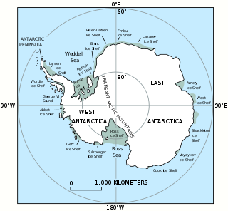
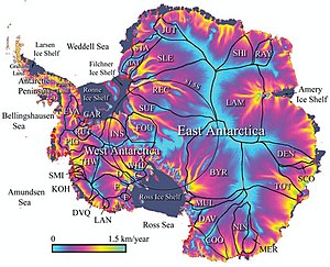
The West Antarctic Ice Sheet (WAIS) is the segment of the continental ice sheet that covers West Antarctica, the portion of Antarctica on the side of the Transantarctic Mountains that lies in the Western Hemisphere. It is classified as a marine-based ice sheet, meaning that its bed lies well below sea level and its edges flow into floating ice shelves. The WAIS is bounded by the Ross Ice Shelf, the Ronne Ice Shelf, and outlet glaciers that drain into the Amundsen Sea.

<span class="mw-page-title-main">Antarctic ice sheet</span> Earths southern polar ice cap

The Antarctic ice sheet is a continental glacier covering 98% of the Antarctic continent, with an area of 14 million square kilometres and an average thickness of over 2 kilometres (1.2 mi). It is the largest of Earth's two current ice sheets, containing 26.5 million cubic kilometres of ice, which is equivalent to 61% of all fresh water on Earth. Its surface is nearly continuous, and the only ice-free areas on the continent are the dry valleys, nunataks of the Antarctic mountain ranges, and sparse coastal bedrock. However, it is often subdivided into East Antarctic ice sheet (EAIS), West Antarctic ice sheet (WAIS), and Antarctic Peninsula (AP), due to the large differences in topography, ice flow, and glacier mass balance between the three regions.

<span class="mw-page-title-main">Melt pond</span> Pools of open water that form on sea ice in the warmer months of spring and summer

Melt ponds are pools of open water that form on sea ice in the warmer months of spring and summer. The ponds are also found on glacial ice and ice shelves. Ponds of melted water can also develop under the ice, which may lead to the formation of thin underwater ice layers called false bottoms.

<span class="mw-page-title-main">Thwaites Glacier</span> Antarctic glacier

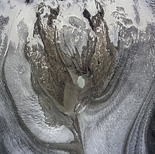
Thwaites Glacier is an unusually broad and vast Antarctic glacier located east of Mount Murphy, on the Walgreen Coast of Marie Byrd Land. It was initially sighted by polar researchers in 1940, mapped in 1959–1966 and officially named in 1967, after the late American glaciologist Fredrik T. Thwaites. The glacier flows into Pine Island Bay, part of the Amundsen Sea, at surface speeds which exceed 2 kilometres (1.2 mi) per year near its grounding line. Its fastest-flowing grounded ice is centered between 50 and 100 kilometres east of Mount Murphy. Like many other parts of the cryosphere, it has been adversely affected by climate change, and provides one of the more notable examples of the retreat of glaciers since 1850.

<span class="mw-page-title-main">Ice stream</span> A region of fast-moving ice within an ice sheet

An ice stream is a region of fast-moving ice within an ice sheet. It is a type of glacier, a body of ice that moves under its own weight. They can move upwards of 1,000 metres (3,300 ft) a year, and can be up to 50 kilometres (31 mi) in width, and hundreds of kilometers in length. They tend to be about 2 km (1.2 mi) deep at the thickest, and constitute the majority of the ice that leaves the sheet. In Antarctica, the ice streams account for approximately 90% of the sheet's mass loss per year, and approximately 50% of the mass loss in Greenland.

<span class="mw-page-title-main">Antarctic bottom water</span> Cold, dense, water mass originating in the Southern Ocean surrounding Antarctica

The Antarctic bottom water (AABW) is a type of water mass in the Southern Ocean surrounding Antarctica with temperatures ranging from −0.8 to 2 °C (35 °F) and absolute salinities from 34.6 to 35.0 g/kg. As the densest water mass of the oceans, AABW is found to occupy the depth range below 4000 m of all ocean basins that have a connection to the Southern Ocean at that level. AABW forms the lower branch of the large-scale movement in the world's oceans through thermohaline circulation.

<span class="mw-page-title-main">Anchor ice</span> Submerged ice anchored to a river bottom or seafloor

Anchor ice is defined by the World Meteorological Organization as "submerged ice attached or anchored to the bottom, irrespective of the nature of its formation". It may also be called bottom-fast ice. Anchor ice is most commonly observed in fast-flowing rivers during periods of extreme cold, at the mouths of rivers flowing into very cold seawater, in the shallow sub or intertidal during or after storms when the air temperature is below the freezing point of the water, and the subtidal in the Antarctic along ice shelves or near floating glacier tongues, and in shallow lakes.

<span class="mw-page-title-main">Nordenskjöld Coast</span> Coast in Antarctica

The Nordenskjöld Coast is located on the Antarctic Peninsula, more specifically Graham Land, which is the top region of the Peninsula. The Peninsula is a thin, long ice sheet with an Alpine-style mountain chain. The coast consists of 15m tall ice cliffs with ice shelves.

<span class="mw-page-title-main">Totten Glacier</span> Glacier in Antarctica

Totten Glacier is a large glacier draining a major portion of the East Antarctic Ice Sheet, through the Budd Coast of Wilkes Land in the Australian Antarctic Territory. The catchment drained by the glacier is estimated at 538,000 km2 (208,000 sq mi), extending approximately 1,100 km (680 mi) into the interior and holds the potential to raise sea level by at least 3.5 m (11 ft). Totten drains northeastward from the continental ice but turns northwestward at the coast where it terminates in a prominent tongue close east of Cape Waldron. It was first delineated from aerial photographs taken by USN Operation Highjump (1946–47), and named by Advisory Committee on Antarctic Names (US-ACAN) for George M. Totten, midshipman on USS Vincennes of the United States Exploring Expedition (1838–42), who assisted Lieutenant Charles Wilkes with correction of the survey data obtained by the expedition.

<span class="mw-page-title-main">Meltwater</span> Water released by the melting of snow or ice

Meltwater is water released by the melting of snow or ice, including glacial ice, tabular icebergs and ice shelves over oceans. Meltwater is often found during early spring when snow packs and frozen rivers melt with rising temperatures, and in the ablation zone of glaciers where the rate of snow cover is reducing. Meltwater can be produced during volcanic eruptions, in a similar way in which the more dangerous lahars form. It can also be produced by the heat generated by the flow itself.

<span class="mw-page-title-main">Overdeepening</span> Characteristic of basins and valleys eroded by glaciers

Overdeepening is a characteristic of basins and valleys eroded by glaciers. An overdeepened valley profile is often eroded to depths which are hundreds of metres below the lowest continuous surface line along a valley or watercourse. This phenomenon is observed under modern day glaciers, in salt-water fjords and fresh-water lakes remaining after glaciers melt, as well as in tunnel valleys which are partially or totally filled with sediment. When the channel produced by a glacier is filled with debris, the subsurface geomorphic structure is found to be erosionally cut into bedrock and subsequently filled by sediments. These overdeepened cuts into bedrock structures can reach a depth of several hundred metres below the valley floor.

Subglacial streams are conduits of glacial meltwater that flow at the base of glaciers and ice caps. Meltwater from the glacial surface travels downward throughout the glacier, forming an englacial drainage system consisting of a network of passages that eventually reach the bedrock below, where they form subglacial streams. Subglacial streams form a system of tunnels and interlinked cavities and conduits, with water flowing under extreme pressures from the ice above; as a result, flow direction is determined by the pressure gradient from the ice and the topography of the bed rather than gravity. Subglacial streams form a dynamic system that is responsive to changing conditions, and the system can change significantly in response to seasonal variation in meltwater and temperature. Water from subglacial streams is routed towards the glacial terminus, where it exits the glacier. Discharge from subglacial streams can have a significant impact on local, and in some cases global, environmental and geological conditions. Sediments, nutrients, and organic matter contained in the meltwater can all influence downstream and marine conditions. Climate change may have a significant impact on subglacial stream systems, increasing the volume of meltwater entering subglacial drainage systems and influencing their hydrology.

<span class="mw-page-title-main">Circumpolar deep water</span> Water mass in the Pacific and Indian oceans formed by mixing of other water masses in the region

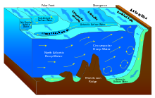
Circumpolar Deep Water (CDW) is a designation given to the water mass in the Pacific and Indian oceans that is a mixing of other water masses in the region. It is characteristically warmer and saltier than the surrounding water masses, causing CDW to contribute to the melting of ice shelves in the Antarctic region.

<span class="mw-page-title-main">Past sea level</span> Sea level variations over geological time scales

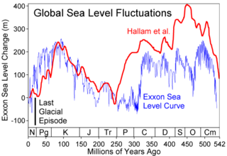
Global or eustatic sea level has fluctuated significantly over Earth's history. The main factors affecting sea level are the amount and volume of available water and the shape and volume of the ocean basins. The primary influences on water volume are the temperature of the seawater, which affects density, and the amounts of water retained in other reservoirs like rivers, aquifers, lakes, glaciers, polar ice caps and sea ice. Over geological timescales, changes in the shape of the oceanic basins and in land/sea distribution affect sea level. In addition to eustatic changes, local changes in sea level are caused by tectonic uplift and subsidence.

An ice shelf basal channel is a type of subglacial meltwater channel that forms on the underside of floating ice shelves connected to ice sheets. Basal channels are generally rounded cavities which form parallel to ice sheet flow. These channels are found mainly around the Greenland and Antarctic ice sheets in places with relatively warm ocean water. West Antarctica in particular has the highest density of basal channels in the world. Basal channels can be tens of kilometers long, kilometers wide, and incise hundreds of meters up into an ice shelf. These channels can evolve and grow just as rapidly as ice shelves can, with some channels having incision rates approaching 22 meters per year. Basal channels are categorized based on what mechanisms created them and where they formed.

References

  1. Scambos, T. A. (2004). "Glacier acceleration and thinning after ice shelf collapse in the Larsen B embayment, Antarctica". Geophysical Research Letters. 31 (18): L18402. Bibcode:2004GeoRL..3118402S. doi: 10.1029/2004GL020670 . hdl: 11603/24296 . S2CID   36917564.
  2. 1 2 3 4 5 6 7 8 Sections 4.5 and 4.6 of Lemke, P.; Ren, J.; Alley, R.B.; Allison, I.; Carrasco, J.; Flato, G.; Fujii, Y.; Kaser, G.; Mote, P.; Thomas, R.H.; Zhang, T. (2007). "Observations: Changes in Snow, Ice and Frozen Ground" (PDF). In Solomon, S.; Qin, D.; Manning, M.; Chen, Z.; Marquis, M.; Averyt, K.B.; Tignor, M.; Miller, H.L. (eds.). Climate Change 2007: The Physical Science Basis. Contribution of Working Group I to the Fourth Assessment Report of the Intergovernmental Panel on Climate Change. Cambridge University Press.
  3. 1 2 3 4 5 6 7 8 9 10 11 12 13 14 Clarke, G. K. C. (2005). "Subglacial processes". Annual Review of Earth and Planetary Sciences. 33 (1): 247–276. Bibcode:2005AREPS..33..247C. doi:10.1146/annurev.earth.33.092203.122621.
  4. 1 2 Bindschadler, Robert A.; King, Matt A.; Alley, Richard B.; Anandakrishnan, Sridhar; Padman, Laurence (22 August 2003). "Tidally Controlled Stick-Slip Discharge of a West Antarctic Ice". Science. 301 (5636): 1087–1089. doi:10.1126/science.1087231. PMID   12934005. S2CID   37375591.
  5. Anandakrishnan, S.; Voigt, D. E.; Alley, R. B.; King, M. A. (April 2003). "Ice stream D flow speed is strongly modulated by the tide beneath the Ross Ice Shelf". Geophysical Research Letters. 30 (7): 1361. Bibcode:2003GeoRL..30.1361A. doi: 10.1029/2002GL016329 . S2CID   53347069.
  6. Walker, Dziga P.; Brandon, Mark A.; Jenkins, Adrian; Allen, John T.; Dowdeswell, Julian A.; Evans, Jeff (16 January 2007). "Oceanic heat transport onto the Amundsen Sea shelf through a submarine glacial trough" (PDF). Geophysical Research Letters. 34 (2): L02602. Bibcode:2007GeoRL..34.2602W. doi:10.1029/2006GL028154. S2CID   30646727.
  7. Heinrich, Hartmut (March 1988). "Origin and Consequences of Cyclic Ice Rafting in the Northeast Atlantic Ocean During the Past 130,000 Years". Quaternary Research. 29 (2): 142–152. Bibcode:1988QuRes..29..142H. doi:10.1016/0033-5894(88)90057-9. S2CID   129842509.
  8. Bond, Gerard C.; Showers, William; Elliot, Mary; Evans, Michael; Lotti, Rusty; Hajdas, Irka; Bonani, Georges; Johnson, Sigfus (1999). "The North Atlantic's 1–2 kyr climate rhythm: Relation to Heinrich events, Dansgaard/Oeschger cycles and the Little Ice Age". Mechanisms of Global Climate Change at Millennial Time Scales. Geophysical Monograph Series. Vol. 112. pp. 35–58. doi:10.1029/GM112p0035. ISBN   978-0-87590-095-7.
  9. Turney, Chris S. M.; Fogwill, Christopher J.; Golledge, Nicholas R.; McKay, Nicholas P.; Sebille, Erik van; Jones, Richard T.; Etheridge, David; Rubino, Mauro; Thornton, David P.; Davies, Siwan M.; Ramsey, Christopher Bronk; Thomas, Zoë A.; Bird, Michael I.; Munksgaard, Niels C.; Kohno, Mika; Woodward, John; Winter, Kate; Weyrich, Laura S.; Rootes, Camilla M.; Millman, Helen; Albert, Paul G.; Rivera, Andres; Ommen, Tas van; Curran, Mark; Moy, Andrew; Rahmstorf, Stefan; Kawamura, Kenji; Hillenbrand, Claus-Dieter; Weber, Michael E.; Manning, Christina J.; Young, Jennifer; Cooper, Alan (25 February 2020). "Early Last Interglacial ocean warming drove substantial ice mass loss from Antarctica". Proceedings of the National Academy of Sciences. 117 (8): 3996–4006. Bibcode:2020PNAS..117.3996T. doi: 10.1073/pnas.1902469117 . PMC   7049167 . PMID   32047039.
  10. Crémière, Antoine; Lepland, Aivo; Chand, Shyam; Sahy, Diana; Condon, Daniel J.; Noble, Stephen R.; Martma, Tõnu; Thorsnes, Terje; Sauer, Simone; Brunstad, Harald (11 May 2016). "Timescales of methane seepage on the Norwegian margin following collapse of the Scandinavian Ice Sheet". Nature Communications. 7 (1): 11509. Bibcode:2016NatCo...711509C. doi:10.1038/ncomms11509. PMC   4865861 . PMID   27167635.
  11. 1 2 3 Easterbrook, Don J., Surface Processes and Landforms, 2nd Edition, Prentice-Hall Inc., 1999[ page needed ]
  12. 1 2 3 Greve, R.; Blatter, H. (2009). Dynamics of Ice Sheets and Glaciers. Springer. doi:10.1007/978-3-642-03415-2. ISBN   978-3-642-03414-5.[ page needed ]
  13. Schoof, C. (2010). "Ice-sheet acceleration driven by melt supply variability". Nature. 468 (7325): 803–806. Bibcode:2010Natur.468..803S. doi:10.1038/nature09618. PMID   21150994. S2CID   4353234.
  14. 1 2 3 4 Boulton, Geoffrey S. (2006). "Glaciers and their Coupling with Hydraulic and Sedimentary Processes". Glacier Science and Environmental Change. pp. 2–22. doi:10.1002/9780470750636.ch2. ISBN   978-0-470-75063-6.
  15. Krawczynski, M. J.; Behn, M. D.; Das, S. B.; Joughin, I. (1 December 2007). "Constraints on melt-water flux through the West Greenland ice-sheet: modeling of hydro- fracture drainage of supraglacial lakes". Eos Trans. AGU. Vol. 88. pp. C41B–0474. Bibcode:2007AGUFM.C41B0474K. Archived from the original on 28 December 2012. Retrieved 4 March 2008.
  16. Bell, R. E.; Ferraccioli, F.; Creyts, T. T.; Braaten, D.; Corr, H.; Das, I.; Damaske, D.; Frearson, N.; Jordan, T.; Rose, K.; Studinger, M.; Wolovick, M. (2011). "Widespread Persistent Thickening of the East Antarctic Ice Sheet by Freezing from the Base". Science. 331 (6024): 1592–1595. Bibcode:2011Sci...331.1592B. doi:10.1126/science.1200109. PMID   21385719. S2CID   45110037.
  17. 1 2 3 Fricker, A.; Scambos, T.; Bindschadler, R.; Padman, L. (March 2007). "An Active Subglacial Water System in West Antarctica Mapped from Space". Science. 315 (5818): 1544–1548. Bibcode:2007Sci...315.1544F. doi:10.1126/science.1136897. ISSN   0036-8075. PMID   17303716. S2CID   35995169.
  18. Pagli, C.; Sigmundsson, F. (2008). "Will present day glacier retreat increase volcanic activity? Stress induced by recent glacier retreat and its effect on magmatism at the Vatnajökull ice cap, Iceland" (PDF). Geophysical Research Letters. 35 (9): L09304. Bibcode:2008GeoRL..35.9304P. doi: 10.1029/2008GL033510 .
  19. 1 2 J. Hansen; M. Sato; P. Hearty; R. Ruedy; M. Kelley; V. Masson-Delmotte; G. Russell; G. Tselioudis; J. Cao; E. Rignot; I. Velicogna; E. Kandiano; K. von Schuckmann; P. Kharecha; A. N. Legrande; M. Bauer; K.-W. Lo (2016). "Ice melt, sea level rise and superstorms: evidence from paleoclimate data, climate modeling, and modern observations that 2 °C global warming could be dangerous". Atmospheric Chemistry and Physics. 16 (6): 3761–3812. arXiv: 1602.01393 . Bibcode:2016ACP....16.3761H. doi: 10.5194/acp-16-3761-2016 . S2CID   9410444.
  20. 1 2 Kessler, Mark A.; Anderson, Robert S.; Briner, Jason P. (2008). "Fjord insertion into continental margins driven by topographic steering of ice". Nature Geoscience. 1 (6): 365. Bibcode:2008NatGe...1..365K. doi:10.1038/ngeo201. Non-technical summary: Kleman, John (2008). "Geomorphology: Where glaciers cut deep". Nature Geoscience. 1 (6): 343. Bibcode:2008NatGe...1..343K. doi:10.1038/ngeo210.
  21. Weertman, J. (1974). "Stability of the Junction of an Ice Sheet and an Ice Shelf". Journal of Glaciology. 13 (67): 3–11. doi: 10.3189/S0022143000023327 . ISSN   0022-1430.
  22. Thomas, Robert H.; Bentley, Charles R. (1978). "A Model for Holocene Retreat of the West Antarctic Ice Sheet". Quaternary Research. 10 (2): 150–170. Bibcode:1978QuRes..10..150T. doi:10.1016/0033-5894(78)90098-4. ISSN   0033-5894. S2CID   129039758.
  23. Mercer, J. H. (1978). "West Antarctic ice sheet and CO2 greenhouse effect: a threat of disaster". Nature. 271 (5643): 321–325. Bibcode:1978Natur.271..321M. doi:10.1038/271321a0. ISSN   0028-0836. S2CID   4149290.
  24. Vaughan, David G. (20 August 2008). "West Antarctic Ice Sheet collapse – the fall and rise of a paradigm" (PDF). Climatic Change. 91 (1–2): 65–79. Bibcode:2008ClCh...91...65V. doi:10.1007/s10584-008-9448-3. ISSN   0165-0009. S2CID   154732005.
  25. 1 2 3 David Pollard; Robert M. DeConto; Richard B. Alley (2015). "Potential Antarctic Ice Sheet retreat driven by hydrofracturing and ice cliff failure". Nature. 412: 112–121. Bibcode:2015E&PSL.412..112P. doi: 10.1016/j.epsl.2014.12.035 .
  26. David Docquier (2016). "Marine Ice Sheet Instability "For Dummies"". EGU.
  27. 1 2 Pattyn, Frank (2018). "The paradigm shift in Antarctic ice sheet modelling". Nature Communications. 9 (1): 2728. Bibcode:2018NatCo...9.2728P. doi:10.1038/s41467-018-05003-z. ISSN   2041-1723. PMC   6048022 . PMID   30013142.
  28. Dow, Christine F.; Lee, Won Sang; Greenbaum, Jamin S.; Greene, Chad A.; Blankenship, Donald D.; Poinar, Kristin; Forrest, Alexander L.; Young, Duncan A.; Zappa, Christopher J. (1 June 2018). "Basal channels drive active surface hydrology and transverse ice shelf fracture". Science Advances. 4 (6): eaao7212. Bibcode:2018SciA....4.7212D. doi:10.1126/sciadv.aao7212. ISSN   2375-2548. PMC   6007161 . PMID   29928691.
  29. "Statement: Thinning of West Antarctic Ice Sheet Demands Improved Monitoring to Reduce Uncertainty over Potential Sea-Level Rise". Jsg.utexas.edu. Retrieved 26 October 2017.
  30. Thoma, M.; Jenkins, A.; Holland, D.; Jacobs, S. (2008). "Modelling Circumpolar Deep Water intrusions on the Amundsen Sea continental shelf, Antarctica" (PDF). Geophysical Research Letters . 35 (18): L18602. Bibcode:2008GeoRL..3518602T. doi:10.1029/2008GL034939. S2CID   55937812.
  31. "After Decades of Losing Ice, Antarctica Is Now Hemorrhaging It". The Atlantic. 2018.
  32. "Marine ice sheet instability". AntarcticGlaciers.org. 2014.
  33. 1 2 Gardner, A. S.; Moholdt, G.; Scambos, T.; Fahnstock, M.; Ligtenberg, S.; van den Broeke, M.; Nilsson, J. (13 February 2018). "Increased West Antarctic and unchanged East Antarctic ice discharge over the last 7 years". The Cryosphere. 12 (2): 521–547. Bibcode:2018TCry...12..521G. doi: 10.5194/tc-12-521-2018 . ISSN   1994-0424.
  34. IMBIE team (2018). "Mass balance of the Antarctic Ice Sheet from 1992 to 2017". Nature. 558 (7709): 219–222. Bibcode:2018Natur.558..219I. doi:10.1038/s41586-018-0179-y. hdl:2268/225208. ISSN   0028-0836. PMID   29899482. S2CID   49188002.
  35. Young, Duncan A.; Wright, Andrew P.; Roberts, Jason L.; Warner, Roland C.; Young, Neal W.; Greenbaum, Jamin S.; Schroeder, Dustin M.; Holt, John W.; Sugden, David E. (2 June 2011). "A dynamic early East Antarctic Ice Sheet suggested by ice-covered fjord landscapes". Nature. 474 (7349): 72–75. Bibcode:2011Natur.474...72Y. doi:10.1038/nature10114. ISSN   0028-0836. PMID   21637255. S2CID   4425075.
  36. Mohajerani, Yara (2018). "Mass Loss of Totten and Moscow University Glaciers, East Antarctica, Using Regionally Optimized GRACE Mascons". Geophysical Research Letters. 45 (14): 7010–7018. Bibcode:2018GeoRL..45.7010M. doi: 10.1029/2018GL078173 . S2CID   134054176.
  37. Greene, Chad A.; Young, Duncan A.; Gwyther, David E.; Galton-Fenzi, Benjamin K.; Blankenship, Donald D. (2018). "Seasonal dynamics of Totten Ice Shelf controlled by sea ice buttressing". The Cryosphere. 12 (9): 2869–2882. Bibcode:2018TCry...12.2869G. doi: 10.5194/tc-12-2869-2018 . ISSN   1994-0416.
  38. Roberts, Jason; Galton-Fenzi, Benjamin K.; Paolo, Fernando S.; Donnelly, Claire; Gwyther, David E.; Padman, Laurie; Young, Duncan; Warner, Roland; Greenbaum, Jamin (23 August 2017). "Ocean forced variability of Totten Glacier mass loss" (PDF). Geological Society, London, Special Publications. 461 (1): 175–186. Bibcode:2018GSLSP.461..175R. doi: 10.1144/sp461.6 . ISSN   0305-8719.
  39. Greene, Chad A.; Blankenship, Donald D.; Gwyther, David E.; Silvano, Alessandro; Wijk, Esmee van (1 November 2017). "Wind causes Totten Ice Shelf melt and acceleration". Science Advances. 3 (11): e1701681. Bibcode:2017SciA....3E1681G. doi:10.1126/sciadv.1701681. ISSN   2375-2548. PMC   5665591 . PMID   29109976.
  40. Naughten, Kaitlin A.; Holland, Paul R.; De Rydt, Jan (23 October 2023). "Unavoidable future increase in West Antarctic ice-shelf melting over the twenty-first century". Nature Climate Change. 13 (11): 1222–1228. Bibcode:2023NatCC..13.1222N. doi: 10.1038/s41558-023-01818-x . S2CID   264476246.

Further reading