
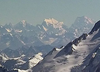
The Karakoram is a mountain range in the Kashmir region spanning the border of Pakistan, China, and India, with the northwestern extremity of the range extending to Afghanistan and Tajikistan. Most of the Karakoram mountain range falls under the jurisdiction of Gilgit-Baltistan, which is controlled by Pakistan. Its highest peak, K2, is located in Gilgit-Baltistan, Pakistan. It begins in the Wakhan Corridor (Afghanistan) in the west, encompasses the majority of Gilgit-Baltistan, Pakistan and extends into Ladakh and Aksai Chin.

Haramosh Peak, also known as Haramosh or Peak 58, is a Karakoram range mountain located in Gilgit-Baltistan, Pakistan. The total population of the Haramosh Valley is at least 8000. The 7,409-meter Haramosh Peak is situated roughly 65 kilometers to the east of Gilgit, within the south-central part of the Rakaposhi-Haramosh Mountains, which is a subrange of the Karakoram range. This mountain rises steeply above the north bank of the Indus River, just upstream from its confluence with the Gilgit River.

The Sulaiman Mountains, also known as Kōh-e Sulaymān or Da Kasē Ghrūna, are a north–south extension of the southern Hindu Kush mountain system in Pakistan and Afghanistan. They rise to form the eastern edge of the Iranian plateau. They are located in the Kandahar, Zabul and Paktia provinces of Afghanistan, and in Pakistan they extend over the northern part of Balochistan and Waziristan as well as Kurram of Khyber Pakhtunkhwa. In southwestern Punjab, the mountains extend into the two districts of Dera Ghazi Khan and Rajanpur, which are located west of the Indus River on the boundary with Balochistan. Bordering the mountains to the east are the plains of the Indus River valley, and to the north are the arid highlands of the Central Hindu Kush whose heights extend up to 3,383 metres (11,099 ft). The total area on which this range spans around 6475 sq. km. Together with the Kirthar Mountains on the border between Balochistan and Sindh, the Sulaiman Mountains form what is known as the Sulaiman-Kirthar geologic province.

The Karakoram Highway, also known as the KKH, National Highway 35, N-35, and the China–Pakistan Friendship Highway, is a 1,300 km (810 mi) national highway which extends from Hasan Abdal in the Punjab province of Pakistan to the Khunjerab Pass in Gilgit-Baltistan, where it crosses into China and becomes China National Highway 314. The highway connects the Pakistani provinces of Punjab and Khyber Pakhtunkhwa plus Gilgit-Baltistan with China's Xinjiang Uyghur Autonomous Region. The highway is a popular tourist attraction and is one of the highest paved roads in the world, passing through the Karakoram mountain range, at 36°51′00″N75°25′40″E at maximum elevation of 4,714 m (15,466 ft) near Khunjerab Pass. Due to its high elevation and the difficult conditions under which it was constructed, it is often referred to as the Eighth Wonder of the World. The highway is also a part of the Asian Highway AH4.

Passu is a small village situated in the Gojal valley of Upper Hunza in the Gilgit Baltistan region of Northern Pakistan. Located along the Karakoram Highway, Passu is a renowned tourist destination. The village is celebrated for its landscapes and breathtaking views of the 7,478-meter Passu Sar mountain, the Passu Glacier, and the Passu Cathedral (Tupopdan) 6,106m.
The Kirthar Mountains are a mountain range that mark the boundary between the Pakistani provinces of Balochistan and Sindh, and which comprise much of the Kirthar National Park. The mountain range forms part of the Kirthar-Sulaiman geological province, which stretches from the Arabian Sea coast north to the Sulaiman Mountains in northwest Pakistan. The highest peak of the mountains is Zardak Peak at 7,430 ft (2,260 m).
Surveyed as K6, but also known as Baltistan Peak, it is a notable peak of the Masherbrum Mountains, a subrange of the Karakoram mountain range in the Gilgit Baltistan region of Pakistan. Despite being much lower than adjoining mountains, the Eight-thousanders and high 7000m peaks such as Masherbrum, K6 has huge, steep faces, and great relief above the nearby valleys.

The Hunza Valley is a mountainous valley in the northern part of the Gilgit-Baltistan region of Pakistan.

The Saltoro Mountains form a subrange within the Karakoram Range and are situated in the southeastern part of the Karakoram. They lie on the southwest side of the Siachen Glacier, which is one of the two longest glaciers in the world outside the polar regions. The name "Saltoro" is also associated with the Saltoro Valley, located west of this range and descending on the Pakistani side of the Saltoro Range, which generally follows the Actual Ground Position Line (AGPL).

Mount Sikaram is a mountain on the Afghanistan–Pakistan border, south of the Kabul River and Khyber Pass. At 4,755 m (15,600 ft), it is the highest peak of the Spīn Ghar, or Safēd Kōh, mountain range.
Nagar Valley once a princely state, now stands as one of the ten districts within the Gilgit-Baltistan region of Pakistan. This valley is situated along the renowned Karakoram Highway, as one travels northward from the city of Gilgit. The valley is home to many high mountain peaks including Rakaposhi (7788m), Diran Peak (7265m), Golden Peak and Rush Peak.
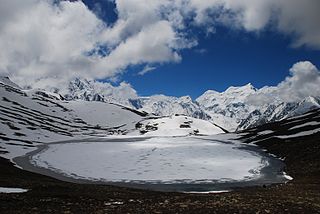
Rush Lake is a high-altitude lake located in Nagar Valley, Gilgit-Baltistan, Pakistan near Rush Peak. At 4,694 metres (15,400 ft), Rush is one of the highest alpine lakes in the world. It is located about 15 km (9 mi) north of Miar Peak and Spantik in the Nagar Valley. It is one of the highest lakes in Pakistan and the 27th-highest lake in the world.

Kalam is a valley located 99 kilometres (62 mi) from Mingora in the northern upper section of Swat Valley along the banks of the Swat River in the Khyber Pakhtunkhwa province of Pakistan. The Swat River was formed as a result of the confluence of two major tributaries, the Gabral and Ushu river.
Tourism in Pakistan is a growing industry. In 2010, Lonely Planet termed Pakistan "tourism's 'next big thing'". The country is geographically and ethnically diverse, and has a number of historical and cultural heritage sites. Condé Nast Traveller ranked Pakistan The Best Holiday Destination for 2020 and also declared it the third-highest potential adventure destination in the world for 2020. As security in the country improves, tourism increases; in two years, it has increased by more than 300%.

The Ganderbal district, is an Indian-administered district in Jammu and Kashmir in the disputed Kashmir region. It was formed in 2007 and has 6 subdistricts (tehsils): Kangan, Ganderbal, Tullamulla, Wakura, Lar, and Gund.

The Actual Ground Position Line (AGPL) divides current positions of Indian and Pakistani military posts and troops along the entire 110 kilometres (68 mi) long frontline in the disputed region of Siachen Glacier. AGPL generally runs along the Saltoro Mountains range, beginning from the northernmost point of the (LOC) at Point NJ 9842 and ending in the north on the Indira Ridge at the India-China-Pakistan LAC tripoint near Sia Kangri about 4 km (2.5 mi) northwest of Indira Col West, with peaks in excess of 7,000 m (23,000 ft) and temperatures ranging to around −55 °C (−67 °F). India gained control of 1,000 square miles (2,600 km2) of disputed territory in 1984 because of its military operations in Siachen. A cease-fire was announced in 2003.
Lulusar-Dodipat National Park is located in the Kaghan Valley in Mansehra District of Khyber-Pakhtunkhwa, Pakistan. The park was created in 2003. The scenic Dudipatsar Lake and Lulusar Lake and peaks are in the park.

Momhil Sar, or Mumhail Sar as pronounced in Wakhi is at 7,414 metres (24,324 ft) above sea level, is the 64th highest mountain peak in the world. Mumhail Sar in Wakhi means the mountain that overlooks or is above Grandmother's cattle pen or paddock. It is situated in Shimshal Valley the Hispar Muztagh subrange of the Karakoram range, a few kilometres to the north-west of its parent peak Trivor.
Sarwali Peak, also known as Dabbar Peak, Toshe Ri, and Toshain-I, is a mountain peak located at an altitude of 6,326 metres (20,755 ft) in Neelum District of the Pakistan-administered Azad Kashmir, in the disputed Kashmir region. It is located at the junction of the Neelam and Shounter valleys on Toshain/Rupal Glacier towering in Rupal Valley of Nanga Parbat. It is the highest point in Azad Jammu and Kashmir.

Haldi Cones are a group of mountains located in Karakoram range in Ghanche district of Gilgit Baltistan in Pakistan. The granite peaks are located in Haldi village located at a distance of 25 km from Khaplu town. Most of these towers and cones are not climbed yet. While the peaks of Khane Valley located in the north of Haldi cones were climbed.
