Indian Bayou | |
|---|---|
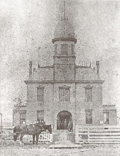
 Indian Bayou School | |
 Indian Bayou Location of Indian Bayou in Louisiana | |
| Coordinates: 30°7′33″N92°14′33″W / 30.12583°N 92.24250°W Coordinates: 30°7′33″N92°14′33″W / 30.12583°N 92.24250°W | |
| Country | United States |
| State | Louisiana |
| Parish | Vermilion |
| Time zone | UTC-6 (CST) |
| • Summer (DST) | UTC-5 (CDT) |
| Area code(s) | 337 |
| FIPS code [1] | 22-37060 |
| GNIS feature ID [1] [2] | 543327 |
Indian Bayou (French : Bayou Indien) is an unincorporated community in Vermilion Parish in southwestern Louisiana, United States. It is part of the Abbeville Micropolitan Statistical Area. It is located approximately seven miles south of Rayne, eight miles north of Kaplan, and fourteen miles southwest of Lafayette. The area acquired its name from the bayou that forms a portion of the northern border of Vermilion Parish with Lafayette and Acadia parishes.

French is a Romance language of the Indo-European family. It descended from the Vulgar Latin of the Roman Empire, as did all Romance languages. French evolved from Gallo-Romance, the spoken Latin in Gaul, and more specifically in Northern Gaul. Its closest relatives are the other langues d'oïl—languages historically spoken in northern France and in southern Belgium, which French (Francien) has largely supplanted. French was also influenced by native Celtic languages of Northern Roman Gaul like Gallia Belgica and by the (Germanic) Frankish language of the post-Roman Frankish invaders. Today, owing to France's past overseas expansion, there are numerous French-based creole languages, most notably Haitian Creole. A French-speaking person or nation may be referred to as Francophone in both English and French.

In law, an unincorporated area is a region of land that is not governed by a local municipal corporation; similarly an unincorporated community is a settlement that is not governed by its own local municipal corporation, but rather is administered as part of larger administrative divisions, such as a township, parish, borough, county, city, canton, state, province or country. Occasionally, municipalities dissolve or disincorporate, which may happen if they become fiscally insolvent, and services become the responsibility of a higher administration. Widespread unincorporated communities and areas are a distinguishing feature of the United States and Canada. In most other countries of the world, there are either no unincorporated areas at all, or these are very rare; typically remote, outlying, sparsely populated or uninhabited areas.

Vermilion Parish is a parish located in the U.S. state of Louisiana. As of the 2010 census, the population was 57,999. The parish seat is Abbeville. The parish was created in 1844.
Contents
Indian Bayou consists of mainly farmland and homes with the exception of a Methodist church, a volunteer fire department, an elementary school, and a few locally owned businesses. Most residents travel to the nearby cities of Crowley or Lafayette for employment or shopping.

Crowley is a city in and the parish seat of Acadia Parish, Louisiana, United States. The population was 13,265 at the 2010 census but 14,225 in 2000, a loss of nearly a thousand persons. It is 63.8 percent Non-Hispanic White.

Lafayette is a city in and the parish seat of Lafayette Parish, Louisiana, located along the Vermilion River in the southwestern part of the state. The city of Lafayette is the fourth-largest in the state, with a population of 126,143 according to 2018 U.S. Census estimates. It is the principal city of the Lafayette, Louisiana Metropolitan Statistical Area, with a 2015 estimated population of 490,488. The larger trade area or Combined Statistical Area of Lafayette-Opelousas-Morgan City CSA was 627,146 in 2015. Its nickname is The Hub City.
At one time, Indian Bayou School served children from Kindergarten through 12th grade. Despite the protests of students and local residents, the Vermilion Parish School Board voted to close the high school in 1991, consolidating with nearby North Vermilion High School. Currently, Indian Bayou Elementary School offers Pre-K through the fifth grade.
Indian Bayou is located at 30.1260374 -92.2426278 along Louisiana Highway 700. Other notable highways passing through the area are Louisiana Hwy 92 and Louisiana Hwy 35.