Loyalhanna Creek is a 50-mile (80 km) long tributary of the Kiskiminetas River in Westmoreland County in the U.S. state of Pennsylvania. The stream is a popular destination for canoeing and recreational trout fishing.

Red Clay Creek is a 12.7-mile-long (20.4 km) tributary of White Clay Creek, running through southeastern Pennsylvania and northern Delaware in the United States. As of 2000, portions of the creek are under wildlife habitat protection.
Bear Run is a 5.0-mile-long (8.0 km) tributary of the Youghiogheny River in Fayette County, Pennsylvania, in the United States.

Slippery Rock Creek is a small stream in Western Pennsylvania, a tributary of Connoquenessing Creek. From its source in Hilliards in Butler County, it flows through McConnells Mill State Park before flowing into the Connoquenessing in Ellwood City. Then, the Connoquenessing flows into the Beaver River just three miles south from the mouth of Slippery Rock.
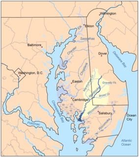
Marshyhope Creek is a 37.0-mile-long (59.5 km) tributary of the Nanticoke River on the Delmarva Peninsula. It rises in Kent County, Delaware, and runs through Caroline County, Maryland, and Dorchester County, Maryland.

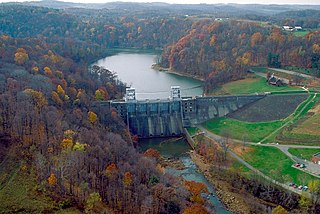
The Casselman River is a 56.5-mile-long (90.9 km) tributary of the Youghiogheny River in western Maryland and Pennsylvania in the United States. The Casselman River drains an area of 576 square miles.

Laurel Hill Creek is a 39.9-mile-long (64.2 km) tributary of the Casselman River in Somerset County, Pennsylvania, in the United States. It is part of the Youghiogheny River watershed, flowing to the Monongahela River, the Ohio River, and ultimately the Mississippi River. Laurel Hill Creek is responsible for draining 126 square miles of the 576 square miles drained by the Casselman River.

Oil Creek is a 46.7-mile (75.2 km) tributary of the Allegheny River in Venango and Crawford counties in the U.S. state of Pennsylvania. It has a drainage area of 319 square miles (830 km2) and joins the Allegheny at Oil City. Attractions along the river include the Drake Well Museum and Oil Creek State Park. The stream was named after the oil that was found along its banks before the historic oil strike by Edwin Drake in Titusville, which Oil Creek flows through. Oil Creek is popular with canoeists and fishers. The creek is rated as a beginners creek for those interested in learning how to safely use canoes and kayaks. Oil Creek is a cold water fishery with bass and trout living in its waters.
Dunbar Creek is a 12.6-mile-long (20.3 km) stream in Fayette County, Pennsylvania, flowing into the Youghiogheny River at Connellsville. The creek is a noted trout stream, with a popular fly fishing only section on its upper portions. The Pennsylvania Fish Commission stocks the stream with brown and brook trout. There are some native brook trout located in its headwaters. The Budinsky hole is a popular fishing spot on the stream.

Jacobs Creek is a 33.4-mile-long (53.8 km) tributary of the Youghiogheny River beginning in Acme, Pennsylvania and draining at its mouth in the town of Jacobs Creek into the Youghiogheny River. Jacobs Creek is the southwestern border of Westmoreland County and the northwestern border of Fayette County. The area was a major producer of rye whiskey in the decades before Prohibition.
Peters Creek is a 16.8-mile-long (27.0 km) tributary of the Monongahela River and part of the Ohio River and Mississippi River watersheds, flowing through southwestern Pennsylvania in the United States.
Redstone Creek is a historically important widemouthed canoe and river boat-navigable brook-sized tributary stream of the Monongahela River in Fayette County, Pennsylvania. The creek is 28.4 miles (45.7 km) long, running from headwaters on Chestnut Ridge north through the city of Uniontown and reaching the Monongahela at Brownsville. Located in a 1/4-mile-wide valley with low streambanks, the site was ideal for ship building in a region geologically most often characterized by steep-plunging relatively inaccessible banks — wide enough to launch and float several large boats, and indeed steamboats after 1811, and slow-moving enough to provide good docks and parking places while craft were outfitting.
Georges Creek is a 17.57 mi (28.28 km) long 4th order tributary to the Monongahela River in Fayette County, Pennsylvania.
Browneller Run is a 1.96 mi (3.15 km) long 2nd order tributary to the Youghiogheny River in Fayette County, Pennsylvania. This is the only stream of this name in the United States.
Washington Run is a 5.16 mi (8.30 km) long 2nd order tributary to the Youghiogheny River in Fayette County, Pennsylvania.
Furnace Run is a 2.70 mi (4.35 km) long 2nd order tributary to the Youghiogheny River in Fayette County, Pennsylvania.
Mounts Creek is a 13.11 mi (21.10 km) long 3rd order tributary to the Youghiogheny River in Fayette County, Pennsylvania.
Connell Run is a 3.14 mi (5.05 km) long 2nd order tributary to the Youghiogheny River in Fayette County, Pennsylvania. This is the only stream of this name in the United States.
Morgan Run is a 5.82 mi (9.37 km) long 2nd order tributary to the Youghiogheny River in Fayette County, Pennsylvania.
Camp Run is a 1.04 mi (1.67 km) long 1st order tributary to the Youghiogheny River in Fayette County, Pennsylvania.