
The District Municipality of Muskoka, more generally referred to as the District of Muskoka or Muskoka, is a regional municipality in Central Ontario, Canada. Muskoka extends from Georgian Bay in the west, to the northern tip of Lake Couchiching in the south, to the western border of Algonquin Provincial Park in the east. A two-hour drive north of Toronto, Muskoka spans 6,475 km2 (2,500 sq mi). Muskoka has some 1,600 lakes, making it a popular cottaging destination.
Lake of Bays is a township municipality within the District Municipality of Muskoka, Ontario, Canada. The township, situated 193 kilometres (120 mi) north of Toronto, is named after the Lake of Bays. During the 2016 census, the township had a population of 3,167 and encompassed 677.91 square kilometres (261.74 sq mi) of land.
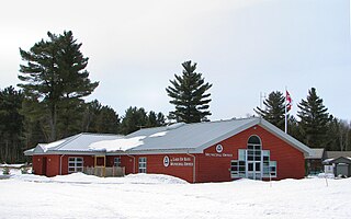
The Township of Muskoka Lakes is a municipality of the District Municipality of Muskoka, Ontario, Canada. It has a year-round population of 6,588.
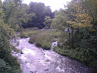
The Indian River is a river in Lanark County in Eastern Ontario, Canada. It is in the Saint Lawrence River drainage basin and is a left tributary of the Mississippi River.

Bala is a compact rural community in the township municipality of Muskoka Lakes, District Municipality of Muskoka in Central Ontario, Canada. It is well-known for the Bala Falls, the source of the Moon River, which flows from Lake Muskoka to the Georgian Bay.

Port Carling is an unincorporated community in the Township of Muskoka Lakes in the Canadian province of Ontario. It has been the municipal seat of the township since 1971. It has several hundred year-round residents and is a service centre for thousands of other seasonal residents in the area.

The Moon River is a river in the municipalities of Georgian Bay and Muskoka Lakes, District Municipality of Muskoka in Central Ontario, Canada. It flows from Lake Muskoka at the community of Bala to Georgian Bay, Lake Huron, south of Parry Sound. The name of the river is thought to be derived from its Ojibwa name moonz-ziibi, which means "moose river".

The Go Home River is a river in the municipality of Georgian Bay, District Municipality of Muskoka in Central Ontario, Canada. It is part of the Great Lakes Basin and lies in geographic Gibson Township. The river flows west, over a dam, from Go Home Lake to empty into Bushby Inlet, on Georgian Bay, Lake Huron. The settlement of Go Home is located about 1.2 kilometres (0.7 mi) further west of the river's mouth.

Nipissing is an incorporated (political) township in Parry Sound District in Central Ontario, Canada. It is on Lake Nipissing and is part of the Almaguin Highlands region. Nipissing was surveyed between 1874 and 1881, and was incorporated in 1888. Among the first settlers in the area were the Chapman and Beatty families. Nipissing Township annexed Gurd Township in 1970. The township also contains a community named Nipissing, which is located on the South River near Chapman's Landing, on the South Bay of Lake Nipissing. The township administrative offices are located in Nipissing.

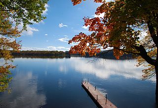
Lake Rosseau is located in Ontario, Canada, about 200 km (120 mi) north of Toronto. The south end of the lake is in the Township of Muskoka Lakes, and the north end is in Seguin Township. The lake is surrounded by many cottages, some dating back to the late 19th century.

Lake Muskoka is located between Port Carling and Gravenhurst, Ontario, Canada. The lake is surrounded by many cottages. The lake is primarily within the boundary of the Township of Muskoka Lakes, the southeast corner is within the boundary of the Town of Gravenhurst and another small portion around the mouth of the Muskoka River is within the boundary of the Town of Bracebridge. The town of Bala is located on the southwest shores of the lake, where the Moon River starts. Lake Muskoka is connected to Lake Rosseau through the Indian River and lock system at Port Carling. The lake is mainly fed by the Muskoka River, Lake Joseph and Lake Rosseau.
Lake Joseph is located in Seguin Township, Ontario. The lake is surrounded by many cottages. Lake Joseph is connected to Lake Rosseau through the narrows at Port Sandfield and the Joseph River.
King's Highway 141, commonly referred to as Highway 141, is a provincially maintained highway in the Canadian province of Ontario. Its western terminus is at Highway 400 south of Horseshoe Lake in Seguin Township while its eastern terminus is at Highway 11 near Port Sydney. The route was designated in 1974 when Highway 532 was renumbered and upgraded from a secondary highway to a King's Highway. The route has remained generally unchanged since, though it was extended by several kilometres on October 7, 2003 when Highway 400 was extended north of Mactier.

Wenonah was a sidewheel steamship, built by Alexander Peter Cockburn, on Lake Muskoka, in 1866. She was the first vessel employed by the Muskoka Navigation Company. She carried passengers, mail and freight, and towed logs for the lumber industry, mainly on a cluster of connected lakes that covered much of the county of Muskoka, Ontario, Canada. Some sources also say she was the first steamship on the Magnetawan River, north of Muskoka.
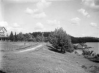
Port Sandfield is a community on Lake Rosseau in Ontario, Canada, located within and governed by the municipality of Muskoka Lakes. It was founded in 1870, when a canal was built connecting Lake Joseph to Lake Rosseau. Alexander Peter Cockburn, a member of the Ontario Provincial Parliament and founder and first President of the Muskoka Settlers’ Association played a leading role in getting the canal funded. The canal was funded at the same time as a lock at Port Carling. The canal and lock allowed a fleet of steamboats to carry freight, mail, cargo and timber over the three largest lakes in the county of Muskoka.

Shadow Lake is a lake in the city of Kawartha Lakes in Central Ontario, Canada. With an area of 356.8 hectares and an elevation of 259 metres (850 ft), it is the second lake upstream of the mouth of the Gull River, and is in the Lake Ontario drainage basin.
Black Donald Lake is a reservoir lake in the Township of Greater Madawaska, Renfrew County and the Township of North Frontenac, Frontenac County in Eastern Ontario, Canada. It is on the Madawaska River and is part of the Saint Lawrence River drainage basin.
The Big East River is a river in Muskoka District and Nipissing District in Northeastern Ontario, Canada. The river is in the Great Lakes Basin, is a left tributary of the Muskoka River, and flows from Algonquin Provincial Park to Huntsville.

Indian River is a First Nations reserve on Lake Rosseau surrounded by Muskoka Lakes and close to the unincorporated community of Port Carling, Ontario. It is shared between the Chippewas of Rama First Nation and the Wahta Mohawks.
Duffy is a railway point and unincorporated place in geographic Medora Township in the municipality of Muskoka Lakes, District Municipality of Muskoka in Central Ontario, Canada. It is on the Canadian Pacific Railway main line between the railway point of Roderick to the south and the dispersed rural community of Mactier to the north. Duffy is on Haggart Creek, and adjacent to Cassady Lake (upstream) and Roderick Lake (downstream) on that creek.

