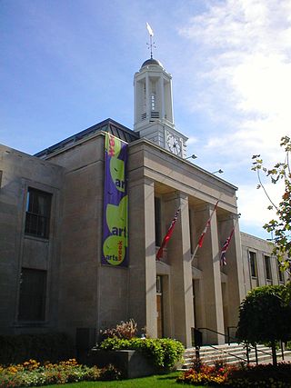
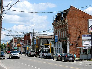
Peterborough is a city on the Otonabee River in Ontario, Canada, about 125 kilometres northeast of Toronto. According to the 2021 Census, the population of the City of Peterborough was 83,651. The population of the Peterborough Census Metropolitan Area (CMA), which includes the surrounding Townships of Selwyn, Cavan Monaghan, Otonabee-South Monaghan, and Douro-Dummer, was 128,624 in 2021. In 2021, Peterborough ranked 32nd among the country's 41 census metropolitan areas according to the CMA in Canada. The current mayor of Peterborough is Jeff Leal.
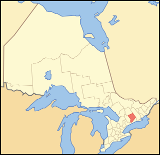
Peterborough County is located in Southern Ontario, Canada. The county seat is The City of Peterborough, which is independent of the county.
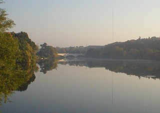
The Otonabee River is a river in Peterborough County in Central Ontario, Canada. The river flows from Katchewanooka Lake, at the north end of the community of Lakefield, through the city of Peterborough to Rice Lake. It is in the Great Lakes Basin and forms part of the Trent-Severn Waterway.
Douro-Dummer is a township in central-eastern Ontario, Canada, in Peterborough County along the Trent-Severn Waterway. It was formed on January 1, 1998, through the amalgamation of Douro and Dummer Townships.
Asphodel–Norwood is a lower tier township municipality in Peterborough County in Central Ontario, Canada, with a 2021 population of 4,658. The land on which the township is situated is the traditional territory of the Mississauga, and became open to European colonization following its survey in 1820. The site that would become Norwood was settled in 1823, and it was incorporated as a village in 1878. The township, in its current form, was created in 1998 by the reunification of the village of Norwood with the surrounding township of Asphodel.

Otonabee–South Monaghan is a township in central-eastern Ontario, Canada, in Peterborough County. The township, located along the Trent–Severn Waterway, was formed on January 1, 1998, through the amalgamation of Otonabee and South Monaghan Townships.

The Trent River is a river in southeastern Ontario which flows from Rice Lake to empty into the Bay of Quinte on Lake Ontario. This river is part of the Trent-Severn Waterway which leads to Georgian Bay. The river is 90 kilometres (56 mi) long. The Trent drains a large portion of south-central Ontario, including most of the Kawartha Lakes and their supplying watersheds.
The Scugog River is a river in the city of Kawartha Lakes in Central Ontario, Canada. It is in the Kawartha Lakes region, is part of the Great Lakes Basin, and is a branch of the Trent-Severn Waterway.

The Crowe River is a river in the counties of Haliburton, Hastings, Northumberland and Peterborough in southern Ontario, Canada. It is in the Lake Ontario drainage basin and is a tributary of the Trent River.
Balsam Lake is a lake in the City of Kawartha Lakes in Central Ontario, Canada. It is in the Great Lakes Basin, is one of the lakes of the Kawartha Lakes, and is at the summit of the Trent–Severn Waterway.
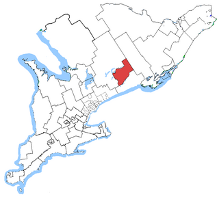
Peterborough—Kawartha is a federal electoral district in Ontario, Canada, that has been represented in the House of Commons of Canada since 1953. Prior to the 2015 election, the riding was known as Peterborough.

Jack Lake is a lake and reservoir in the municipalities of Havelock-Belmont-Methuen and North Kawartha, Peterborough County in Central Ontario, Canada, about 100 mi (160 km) directly northeast of Toronto and at the edge of the Canadian Shield in the northeastern portion of the Kawartha lakes region. The lake is in the Great Lakes Basin, and serves as a small headwater pond for the Trent-Severn Waterway. The Dispersed rural community of Jack Lake is on the northwest shore of the lake, reached by Peterborough County Road 52 / Jack Lake Road from the community of Apsley, about 5 kilometres (3.1 mi) to the north on Ontario Highway 28.
Silver Lake is a small lake in the city of Kawartha Lakes in Central Ontario, Canada. Located near the community of Coboconk, it is the lowest lake on the Gull River, a drainage basin that supplies water at its mouth to Balsam Lake at the top of the Trent-Severn Waterway. Like many other lakes in the Kawarthas, Silver Lake lies in a depression formed between the Precambrian granite to the north, and the Ordovician limestone to the south.
Shadow Lake is a lake in the city of Kawartha Lakes in Central Ontario, Canada. With an area of 356.8 hectares and an elevation of 259 metres (850 ft), it is the second lake upstream of the mouth of the Gull River, and is in the Lake Ontario drainage basin.
Jackson Creek is a creek in Peterborough, Ontario, Canada. It is part of the Great Lakes Basin, and flows to its mouth at Little Lake as a right tributary of the Otonabee River. The Otonabee flows via the Trent River to Lake Ontario.
Koshlong Creek is a river in geographic Glamorgan Township in the municipality of Highlands East, Haliburton County in Central Ontario, Canada. The river is in the Great Lakes Basin and is a left tributary of the Burnt River.
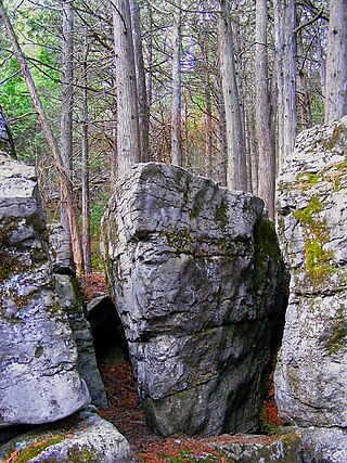
The Warsaw Caves are a group of caverns, a geological feature located in the Warsaw Caves Conservation Area near the village of Warsaw, Ontario, Canada. The caves have long passages and mostly small open areas which are accessible to spelunkers.
The Otonabee Region Conservation Authority (ORCA), sometimes shortened to Otonabee Conservation, is a conservation authority in Ontario, Canada. Established in 1959 and based in Peterborough, its member municipalities include Asphodel-Norwood, Cavan-Monaghan, Douro-Dummer, City of Kawartha Lakes, Otonabee–South Monaghan, City of Peterborough, Selwyn, and Trent Hills. Major watercourses within the watershed administered by ORCA include the Otonabee, Indian, and Ouse rivers, and Baxter, Cavan, Jackson, Miller and Squirrel creeks.
Black Lake is a lake in the municipality of Dysart et al, Haliburton County in Central Ontario, Canada. It is part of the Great Lakes Basin and lies within geographic Dysart Township.

Little Lake is a small lake on the Otonabee River in the city of Peterborough, Ontario, Canada. The lake is in the downtown of the city and is used for fishing, swimming, boating, and for various special events. The lake lies on the water route from Lake Ontario to the Kawartha Lakes. The area around the lake was first settled by Europeans around the start of the 19th century. Steam- and water-powered saw mills were built on the lake and on the river upstream to prepare lumber for shipment overseas. Sawdust and other debris from the mills polluted the lake, killed the fish and clogged up the navigable channels. The smell was so noxious it drove residents near the lake to move. These problems were resolved by the end of the century, when the lake became a hub on the new Trent-Severn Waterway from Lake Ontario to Lake Huron. However, industries attracted by cheap hydroelectric power, such as General Electric used the lake for disposal of industrial chemicals for many years. The pollutants seems to be mostly contained in the sediment, and the lake is now considered safe for recreational use.
