Isla Cristina

Last updated
Isla Cristina (2008). Isla Cristina puerto deportivo.JPG
Isla Cristina (2008).
Isla Cristina, Spain
Ronda Norte.jpg
Flag of Isla Cristina Spain.svg
Escudo de Isla Cristina.svg
Map of Isla Cristina (Huelva).png
Location of Isla Cristina
Municipality Huelva
Government
   Mayor María Luisa Faneca
Area
  Total
50 km2 (20 sq mi)
  Land50 km2 (20 sq mi)
  Water0.00 km2 (0.00 sq mi)
Population
 (2018) [1]
  Total
21,077
  Density420/km2 (1,100/sq mi)
Time zone UTC+1 (CET)
  Summer (DST) UTC+2 (CEST)
Website

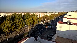
Isla Cristina is a city and municipality located in the province of Huelva, Spain, close to the Portuguese border. According to the 2009 census, the city has a population of 21,324 inhabitants.

Contents

Isla Cristina remains one of the most important fishing ports in Andalusia, its catch being highly prized throughout Spain.

It is a popular summer holiday resort, particularly with the Spaniards themselves. Sevillanos flock to the area in July and August, much of the attraction being the kilometers of 'Blue Flag' standard beaches.

Toponymy

Isla Cristina was given its current name on April 12, 1834 in honor of Maria Christina of the Two Sicilies and her service to the regions of Andalusia and Extremadura during the cholera epidemic of 1833–34. The city was originally called La Higuerita (English: The Little Fig Tree), also La Figarilla or La Figuerta (depending on the language) when it was founded in 1755. The name was christened as Real Isla de La Higuerita (English: Royal Island of the Little Fig Tree) in 1802.

Symbols

The city's main symbols are the water well, the fig tree and the sea, which reflect the culture and history of the city.

Environment

The marismas de Isla Cristina, next to the towns of Ayamonte and Isla Cristina, are a protected nature reserve.

See also

Related Research Articles

<span class="mw-page-title-main">Andalusia</span> Autonomous community of Spain

Andalusia is the southernmost autonomous community in Peninsular Spain, located in the south of the Iberian Peninsula, in southwestern Europe. It is the most populous and the second-largest autonomous community in the country. It is officially recognised as a historical nationality and a national reality. The territory is divided into eight provinces: Almería, Cádiz, Córdoba, Granada, Huelva, Jaén, Málaga, and Seville. Its capital city is Seville, while the seat of its High Court of Justice is the city of Granada.

<span class="mw-page-title-main">Province of Seville</span> Province of Spain

The Province of Seville is a province of southern Spain, in the western part of the autonomous community of Andalusia. It borders the provinces of Málaga and Cádiz in the south, Huelva in the west, Badajoz in the north and Córdoba in the east. Seville is the province's as well as the Andalusian autonomous community's capital.

<span class="mw-page-title-main">Province of Cádiz</span> Province of Spain

Cádiz is a province of southern Spain, in the southwestern part of the autonomous community of Andalusia. It is the southernmost part of mainland Spain, as well as the southernmost part of continental Europe.

<span class="mw-page-title-main">Province of Huelva</span> Province of Spain

Huelva is a province of southern Spain, in the western part of the autonomous community of Andalusia. It is bordered by Portugal, the provinces of Badajoz, Seville, and Cádiz, and the Atlantic Ocean. Its capital is Huelva.

<span class="mw-page-title-main">Huelva</span> City in Andalusia, Spain

Huelva is a municipality of Spain and the capital of the province of Huelva, in the autonomous community of Andalusia. Located in the southwest of the Iberian Peninsula, it sits between the estuaries of the Odiel and Tinto rivers on the Atlantic coast of the Gulf of Cádiz. According to the 2010 census, the city had a population of 149,410.

<span class="mw-page-title-main">El Campillo, Huelva</span> Municipality in Andalusia, Spain

El Campillo, or Campillo, is a municipality of Spain located in the province of Huelva, autonomous community of Andalusia. The municipality spans across a total area of 90.72 km2 and, as of 1 January 2023, it has a registered population of 2,015.

<span class="mw-page-title-main">Cartaya</span> Municipality & Town in Andalusia, Spain

Cartaya is a Spanish locality and municipality in the Province of Huelva,. In 2010 it had 18,415 inhabitants. Its surface area is 226.4 km2 and has a density of 81.34 people per km2.

<span class="mw-page-title-main">Ayamonte</span> Municipality in Andalusia, Spain

Ayamonte is a town and municipality of Spain belonging to the province of Huelva, Andalusia. It is located near the border with Portugal on the mouth of the Guadiana River. According to the 2015 census, the city had a population of 20,357 inhabitants.

<span class="mw-page-title-main">Roman Catholic Diocese of Huelva</span> Roman Catholic diocese in Spain

The Diocese of Huelva is a Latin Church diocese of the Catholic Church located in south-western Spain, and its borders coincide with those of the civil province of Huelva, part of the autonomous community of Andalusia. The diocese forms part of the Ecclesiastical Province of Seville, and is thus suffragan to the Archdiocese of Seville.

<span class="mw-page-title-main">Los Remedios (district)</span> District of Seville, Andalusia, Spain

Los Remedios is a district of Seville, the regional capital of Andalusia, Spain. It is located on the Isla de La Cartuja, south of the district of Triana, between two forks of the Guadalquivir river. It is linked by bridge to the city centre and the districts of Distrito Sur and Bellavista-La Palmera. From the western side of the island, it is linked by road bridge to the city of San Juan de Aznalfarache and shares a boundary in the Guadalquivir with the city of Gelves. The southern tip of La Cartuja is opposite the municipality of Dos Hermanas.

<span class="mw-page-title-main">Islantilla</span>

Islantilla is a seaside town located next to La Antilla, between the municipalities of Lepe and Isla Cristina, in Andalusia, Spain. Islantilla belongs to a tourist region called "Costa de la Luz". Huelva is an urban center close to Islantilla. Islantilla attracts thousands of tourists per year and is known to be one of the most beautiful beach towns in Spain.

<span class="mw-page-title-main">Wharf of the Caravels</span> Maritime museum in Palos de la Frontera, Spain

The Wharf of the Caravels is a museum in Palos de la Frontera, in the province of Huelva, autonomous community of Andalusia, Spain. Its most prominent exhibits are replicas of Christopher Columbus's boats for his first voyage to the Americas, the Niña, the Pinta, and the Santa María. These were built in 1992 for the Celebration of the Fifth Centenary of the Discovery of the Americas. The replica caravels were built between 1990 and 1992, put through shakedown voyages and then, in 1992, sailed the route of Columbus's voyage.

<span class="mw-page-title-main">Romería de El Rocío</span> Pilgrimage in Spain

The Romería de El Rocío is a procession/pilgrimage on the second day of Pentecost to the Hermitage of El Rocío in the countryside of Almonte (Huelva), Andalucia, Spain, in honor of the Virgin of El Rocío. In recent years the Romería has brought together roughly a million pilgrims each year.

<span class="mw-page-title-main">Rociana del Condado</span> Place in Andalusia, Spain

Rociana del Condado is a town located in the province of Huelva, Andalusia, Spain.

<span class="mw-page-title-main">International University of Andalucía</span> Public university in Andalusia, Spain

The International University of Andalucía or UNIA is a university in Andalusia, set up in 1994 to complete the region's educational system. It offers postgraduate and specialty courses. It has campuses in four Andalusian provinces: Huelva, Jaén, Málaga, and Seville.

<span class="mw-page-title-main">Marismas de Isla Cristina</span>

The Marismas de Isla Cristina are located at the mouth of the river Carreras in the province of Huelva, Andalusia, in southern Spain. Created in 1989, the natural park has a surface area of 21.45 square kilometres (8.28 sq mi), shared between the municipalities of Ayamonte and Isla Cristina.

<span class="mw-page-title-main">Saltes Island</span>

Saltes Island is a fluvial islet in the Huelva River estuary, in the province of Huelva, Andalusia, Spain. It is part of the Odiel Marshes biosphere reserve.

<span class="mw-page-title-main">Port of Isla Cristina</span> Port in Huelva, Andalusia

The port of Isla Cristina, belonging to the maritime province of Huelva on the Spanish Costa de la Luz, is the port with the highest turnover in fresh fish in Andalusia and one of the first in tonnage and importance of catches at national level. It is one of the 23 main fishing ports in Spain designated by the FAO. It exports its products to all of Spain and much of Europe. It was originally developed as a way to support the fishing activity of the first settlers in the area in the 18th century. It has grown steadily in extension, reaching over 640,000 m² in 2009 after its latest expansion, although not in terms of the landing of catches. The 1920s marked the highest number of fish landed with almost 16,000 tons in a single year, highlighting the tuna almadraba. As a sardine port it has been, for decades, one of the first in Spain and the traditional species of the port.

<span class="mw-page-title-main">Torre del Catalán</span> Watchtower in Lepe, Spain

The Torre del Catalán is a watchtower located in Lepe, in the province of Huelva (Spain), declared Bien de Interés Cultural.

<span class="mw-page-title-main">Gibraleón-Ayamonte line</span> Former railway line in Spain.

The Gibraleón-Ayamonte line, also known as the Huelva-Ayamonte line, was a 49-kilometer-long Iberian gauge Spanish railway line that came to operate in the province of Huelva. The line was in operation between 1936 and 1987, covering the western coast of Huelva.

References

  1. Municipal Register of Spain 2018. National Statistics Institute.
Wooden bridge to the beach (Puente de la Gola). Isla Cristina Puente de la Gola R01.jpg
Wooden bridge to the beach (Puente de la Gola).

37°11′57″N7°19′17″W / 37.19917°N 7.32139°W / 37.19917; -7.32139