San Juan del Puerto, Spain

Last updated
San Juan del Puerto
Bandera San Juan del Puerto.jpg
Escudo San Juan del Puerto.png
Country Spain
Autonomous community Andalusia
Province Huelva
Area
  Total45 km2 (17 sq mi)
Elevation
10 m (30 ft)
Population
 (2018) [1]
  Total9,198
  Density200/km2 (530/sq mi)
Time zone UTC+1 (CET)
  Summer (DST) UTC+2 (CEST)
Website http://www.sanjuandelpuerto.es/
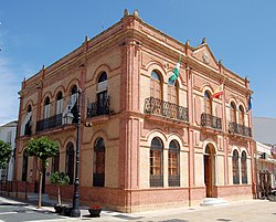
Facade of San Juan del Puerto town hall Ayuntamiento San Juan del Puerto 01.jpg
Facade of San Juan del Puerto town hall

San Juan del Puerto, Spain is a municipality located in the province of Huelva, Spain. In 2005 it had a population of 6,881.

Related Research Articles

<span class="mw-page-title-main">San Juan, Puerto Rico</span> Capital and largest city of Puerto Rico

San Juan is the capital city and most populous municipality in the Commonwealth of Puerto Rico, an unincorporated territory of the United States. As of the 2020 census, it is the 57th-largest city under the jurisdiction of the United States, with a population of 342,259. San Juan was founded by Spanish colonists in 1521, who called it Ciudad de Puerto Rico.

<span class="mw-page-title-main">Castillo San Felipe del Morro</span> 16th-century fortress and citadel in Puerto Rico

Castillo San Felipe del Morro, most commonly known as El Morro(The Promontory), is a large fortress and citadel in the historic district of Old San Juan, Puerto Rico. Commissioned by King Charles I of Spain in 1539, it was first built as a fortified tower in honor of King Philip II, who oversaw its expansion into a hornwork fort by 1595. Over the next 200 years, especially in the reign of King Charles III, El Morro continued to be developed to reach its current form in 1787. Rising 140 ft from the Atlantic shoreline with 18 to 25 ft thick walls, the six-leveled edifice stands on a steep, rocky headland promontory on San Juan Islet guarding the entry to San Juan Bay, the harbor of Old San Juan. El Morro, alongside La Fortaleza, San Cristóbal, El Cañuelo, and other forts part of the Walls of Old San Juan, protected strategically and militarily important Puerto Rico, or La Llave de las Indias , from invasion by competing world powers during the Age of Sail. It was designated a World Heritage Site by UNESCO in 1983.

<span class="mw-page-title-main">Chinandega Department</span> Department of Nicaragua

Chinandega is a department in Nicaragua, located on the border with Honduras. It covers an area of 4,822 km2 and has a population of 441,897. The indigenous inhabitants of Chinandega are the Chorotegas and the Nahuas, and was the location of the pre-Columbian Nahua kingdom of Teswatlan. The capital is the city of Chinandega.

<span class="mw-page-title-main">Roman Catholic Diocese of Mayagüez</span> Diocese of the Catholic Church

The Diocese of Mayagüez is a Latin Church ecclesiastical territory or diocese of the Catholic Church in the United States and consists of the western part of the island of Puerto Rico, an American commonwealth. The diocese is led by a prelate bishop, who pastors the motherchurch in the City of Mayagüez, Catedral Nuestra Señora de la Candelaria in front of the Plaza Colón.

<span class="mw-page-title-main">Río Piedras, Puerto Rico</span> District of San Juan, Puerto Rico

Río Piedras is a populous district of San Juan, and former town and municipality of Puerto Rico, which was merged with the municipality of San Juan in 1951. The district today is composed of various barrios such as Pueblo and Universidad. The historic town was founded in 1714 as El Roble, it was given municipality rights in 1823, and since 1903 it has been the home of the University of Puerto Rico's main campus, earning the popular name of Ciudad Universitaria today. The downtown and historic center of Río Piedras is officially known as the Pueblo barrio of the municipality of San Juan.

<span class="mw-page-title-main">Manuel Quimper</span> 18/19th-century Spanish Peruvian explorer, cartographer, colonial official, and naval officer

Manuel Quimper Benítez del Pino was a Spanish Peruvian explorer, cartographer, naval officer, and colonial official. He participated in charting the Strait of Juan de Fuca and the Sandwich Islands in the late 18th century. He was later appointed a colonial governor in his native Peru at the beginning of the fight for independence there. He retired to Spain, but was able to return to Peru where he served as a naval officer in the new republic and pursued a literary career, publishing over 20 books about his experiences before his death there in Lima.

<span class="mw-page-title-main">Santurce, San Juan, Puerto Rico</span> Barrio of Puerto Rico

Santurce is a barrio of San Juan. Its population in 2020 was 69,469. It is also the biggest and most populated of all the barrios in the capital city with a larger population than most municipalities of Puerto Rico and one of the most densely populated areas of the island .

<span class="mw-page-title-main">Fonseca, La Guajira</span> Municipality and town in Caribbean, Colombia

Fonseca is a municipality located in the Colombian Department of La Guajira. The town celebrates the Festival del Retorno in honor of St Augustine with religious celebrations, vallenato music events and others.

<span class="mw-page-title-main">San Juan de Aznalfarache</span> City in Andalusia, Spain

San Juan de Aznalfarache is a city located in the province of Seville, Spain. According to the 2006 census (INE), the city has a population of 20,121 inhabitants.

<span class="mw-page-title-main">San Juan de la Encinilla</span> Municipality in Castile and León, Spain

San Juan de la Encinilla is a municipality located in the province of Ávila, Castile and León, Spain. According to the 2006 census (INE), the municipality has a population of 124 inhabitants.

<span class="mw-page-title-main">Valdefuentes del Páramo</span> Place in Castile and León, Spain

Valdefuentes del Páramo is a municipality located in the province of León, Castile and León, Spain. According to the 2004 census (INE), the municipality has a population of 388 inhabitants.

<span class="mw-page-title-main">Puerto Rico Department of State</span> Government of Puerto Rico

The Department of State of Puerto Rico was created in July 1952 and is responsible of promoting the cultural, political, and economical relations between Puerto Rico, other jurisdictions of the United States and foreign countries.

<span class="mw-page-title-main">San José Church</span> Catholic church in San Juan, Puerto Rico

San José Church, located in Old San Juan within the historic colonial zone of the capital of Puerto Rico, is one of the first significant works of architecture on the island. The church is one of the earliest surviving examples of 16th-century Spanish Gothic architecture in the Western hemisphere.

<span class="mw-page-title-main">Playita del Condado</span> Beach located in Condado, Puerto Rico

Playita del Condado is a beach located at the end of Avenida Ashford in Condado, Puerto Rico.

The following is a timeline of the history of the municipality of San Juan, Puerto Rico.

Puerto Rico topics have been featured on the stamps of Spain and of the United States. Spanish stamps are found at Postage stamps and postal history of Puerto Rico.

<span class="mw-page-title-main">Condado Beach</span> Beach in Puerto Rico

Condado Beach is a large public-access beach located in Condado, a district of Santurce in San Juan, Puerto Rico.

<span class="mw-page-title-main">Ocean Park Beach</span> Place in San Juan, Puerto Rico

Ocean Park Beach is a large public-access beach located in Ocean Park, a neighborhood of the barrio (district) of Santurce in San Juan, Puerto Rico. The beach used to be known as Último Trolley Beach, since it was the site of the San Juan–Condado streetcar line terminal. A small section located close to Dr. José Celso Barbosa Park is still referred to as El Último Trolley.

<span class="mw-page-title-main">El Escambrón Beach</span> Beach in Puerto Rico

El Escambrón Beach is a public-access beach located in the San Juan Antiguo sub-district (subbarrio) of Puerta de Tierra, next to the Luis Muñoz Rivera Park in San Juan, Puerto Rico. The beach and recreational complex are located on the grounds of the former Escambrón Beach Club and Hotel which featured a large swimming pool enclosed by breakwaters. Although the pool no longer exists, the beach is still enclosed by a series of coral reefs and other natural breakwaters, such as the Peñón de San Jorge reef, making it popular for swimmers and families.

<span class="mw-page-title-main">Plaza del Quinto Centenario</span> Square in San Juan, Puerto Rico

Plaza del Quinto Centenario, also Plaza del V Centenario, popularly referred to as Plaza del Tótem, is a modern square in Old San Juan, Puerto Rico, inaugurated in 1992 to commemorate the 500th anniversary of the European discovery and Spanish conquest of Puerto Rico and the Americas and the first European settlement of San Juan. The square is located between the Ballajá and Mercado neighborhoods of the San Juan Antiguo barrio of San Juan, Puerto Rico. It is located next to the Ballajá Barracks, the Puerto Rican National Gallery and the San José Church, close to El Morro and the San Juan National Historic Site.

References

  1. Municipal Register of Spain 2018. National Statistics Institute.

Crazy mesta.

37°19′N6°50′W / 37.317°N 6.833°W / 37.317; -6.833