Jacobs Creek (Kansas)

Last updated

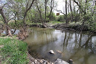
Jacobs Creek is a tributary of the Cottonwood River in the Flint Hills of south central Kansas in the United States. [1]

Tributary stream or river that flows into a main stem river or lake

A tributary or affluent is a stream or river that flows into a larger stream or main stem river or a lake. A tributary does not flow directly into a sea or ocean. Tributaries and the main stem river drain the surrounding drainage basin of its surface water and groundwater, leading the water out into an ocean.

Cottonwood River (Kansas) river in the United States of America

Cottonwood River is one of the principal tributaries of the Neosho River in central Kansas of the United States.

Flint Hills landform

The Flint Hills, historically known as Bluestem Pastures or Blue Stem Hills, are a region in eastern Kansas and north-central Oklahoma named for the abundant residual flint eroded from the bedrock that lies near or at the surface. It consists of a band of hills stretching from Kansas to Oklahoma, extending from Marshall and Washington Counties in the north to Cowley County, Kansas and Kay and Osage Counties in Oklahoma in the south, to Geary and Shawnee Counties west to east. Oklahomans generally refer to the same geologic formation as the Osage Hills or "the Osage."

The headwaters are just south of the Kansas Turnpike and the mouth is at its confluence with the Cottonwood River between Emporia and Saffordville in Kansas. The terrain of the watershed is hilly and used primarily as rangeland. The drainage area upstream of the Kansas Turnpike is only about a few square miles. Jacobs Creek crosses the slightly elevated embankment of the turnpike through culverts.

The Kansas Turnpike is a 236-mile-long (380 km), freeway-standard toll road that lies entirely within the U.S. state of Kansas. It runs in a general southwest–northeast direction from the Oklahoma border to Kansas City. It passes through several major Kansas cities, including Wichita, Topeka, and Lawrence. The turnpike is owned and maintained by the Kansas Turnpike Authority (KTA), which is headquartered in Wichita.

Emporia, Kansas City and County seat in Kansas, United States

Emporia is a city in and the county seat of Lyon County, Kansas, United States. As of the 2010 census, the city population was 24,916. Emporia lies between Topeka and Wichita at the intersection of U.S. Route 50 with Interstates 335 and 35 on the Kansas Turnpike. Emporia is also a college town, home to Emporia State University and Flint Hills Technical College.

Saffordville, Kansas Unincorporated community in Kansas, United States

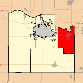
Saffordville is an unincorporated community in Chase County, Kansas, United States.

The Jacobs Creek Flood occurred in 2003.

See also

Related Research Articles

Cottonwood Falls, Kansas City and County seat in Kansas, United States

Cottonwood Falls is the largest city and county seat of Chase County, Kansas. As of the 2010 census, the city population was 903.

Strong City, Kansas City in Kansas, United States

Strong City is a city in Chase County, Kansas, United States. Originally known as Cottonwood Station, in 1881 it was renamed Strong City after William Barstow Strong, then vice-president and general manager, and later president of the Atchison, Topeka and Santa Fe Railway. As of the 2010 census, the city population was 485.

Green Country official tourism region of Oklahoma

Green Country, sometimes referred to as Northeast Oklahoma, is the northeastern portion of the U.S. state of Oklahoma, which lies west of the northern half of Arkansas, the southwestern corner of Missouri, and south of Kansas.

Jacobs Creek, Jacob's Creek or Jacob Creek may refer to:

East-Central Kansas is a region of Kansas. Extending roughly from Osage County, Franklin County, and Miami County in the north to Coffey County, Anderson County and Linn County in the south. The eastern border is Missouri. The region then extends westward towards the Flint Hills to Lyon County. The region is rich with Kansas history, as many locations of this region saw battles in Bleeding Kansas. The infamous abolitionist John Brown and his men battled in Osawatomie. The region geographically features rolling hills and deep forested river valleys. The main crop of this predominantly agricultural region is corn. Much of the area is powered by Wolf Creek Nuclear Generating Station which is located near Burlington. The area is more forested and more moist compared to the rest of the state. The most populous cities of this region include:

Bazaar, Kansas Unincorporated community in Kansas, United States

Bazaar is an unincorporated community in Chase County, Kansas, United States. The community is part of the Emporia Micropolitan Statistical Area.

Plum Creek (Cottonwood River) river in United States of America

Plum Creek is a 35.4-mile-long (57.0 km) stream near the city of Walnut Grove, Minnesota. It passes to the northwest of the town, flowing northeasterly to the Cottonwood River, with its waters then flowing to the Minnesota River and eventually the Mississippi River. Plum Creek lends its name to a regional library network.

Eudora Township, Douglas County, Kansas Township in Kansas, United States

Eudora Township is a township in Douglas County, Kansas, USA. As of the 2010 census, its population was 6,724.

Grant Township, Douglas County, Kansas Township in Kansas, United States

Grant Township is a township in Douglas County, Kansas, USA. As of the 2000 census, its population was 442.

Kanwaka Township, Douglas County, Kansas Township in Kansas, United States

Kanwaka Township is a township in Douglas County, Kansas, USA. As of the 2000 census, its population was 1,317. The name is a portmanteau of the Kansas River and Wakarusa River.

Lecompton Township, Douglas County, Kansas Township in Kansas, United States

Lecompton Township is a township in Douglas County, Kansas, USA. As of the 2000 census, its population was 1,761.

Palmyra Township, Douglas County, Kansas Township in Kansas, United States

Palmyra Township is a township in Douglas County, Kansas, USA. As of the 2000 census, its population was 5,760. It was named after a small trail stop on the Santa Fe Trail that was later absorbed into Baldwin City. When it was first established in 1855, it was called Calhoun, until 1858.

Wakarusa Township, Douglas County, Kansas Township in Kansas, United States

Wakarusa Township is a township in Douglas County, Kansas, USA. As of the 2010 census, its population was 2,318. It was named for the Wakarusa River which flows through Douglas County from Wabaunsee County to the Kansas River near Eudora.

Clements, Kansas Unincorporated community in Kansas, United States

Clements is an unincorporated community in Chase County, Kansas, United States.

The Jacobs Creek flood, also referred to as the Kansas Turnpike flash flood, was a flash flood of the Jacobs Creek that occurred on the night of August 30, 2003, 11 miles (18 km) southwest of Emporia, Kansas, on the Kansas Turnpike. The deadly flash flood occurred on Labor Day weekend and killed six people, five inside of vehicles swept away by the floodwaters and one person who was attempting to rescue those trapped.

Putah Creek State Wildlife Area

Putah Creek Wildlife Area is a state wildlife area of Solano County, California. The 670 acre reserve lies to the southeast of Lake Berryessa, to the south of Monticello Dam and the confluence of Putah Creek and Cold Creek. Trees found here include cottonwood, blue oak and chaparral. Deer, quail, California towhee, Bullock's oriole, and black-headed grosbeak are also found in the area, which also includes Stebbins Cold Canyon Reserve.

Dry Creek is a stream in Redwood and Cottonwood counties, in the U.S. state of Minnesota. It is a tributary of the Cottonwood River.

Cedar Creek, also called Brush Creek, is a stream in Chase County, Kansas. A tributary of the stream is Coon Creek, which is 11 miles (18 km) long. The Cedar Creek's headwaters include three streams, the Cedar Creek, Bill's Creek, and Middle Creek. Cedar Creek and the south fork of the Cottonwood River flow into the Cottonwood River, which is a tributary of the Neosho River. Minnows, crayfish, and spotted bass reside in the stream.

References

Coordinates: 38°16′20″N95°52′01″W / 38.272241°N 95.866933°W / 38.272241; -95.866933

Geographic coordinate system Coordinate system

A geographic coordinate system is a coordinate system that enables every location on Earth to be specified by a set of numbers, letters or symbols. The coordinates are often chosen such that one of the numbers represents a vertical position and two or three of the numbers represent a horizontal position; alternatively, a geographic position may be expressed in a combined three-dimensional Cartesian vector. A common choice of coordinates is latitude, longitude and elevation. To specify a location on a plane requires a map projection.