Longueuil is a city in the province of Quebec, Canada. It is the seat of the Montérégie administrative region and the central city of the urban agglomeration of Longueuil. It sits on the south shore of the Saint Lawrence River directly across from Montreal. The population as of the Canada 2016 Census totalled 239,700, making it Montreal's second largest suburb, the fifth most populous city in Quebec and twentieth largest in Canada.

Sherbrooke is a city in southern Quebec, Canada. Sherbrooke is situated at the confluence of the Saint-François and Magog rivers in the heart of the Estrie administrative region. Sherbrooke is also the name of a territory equivalent to a regional county municipality (TE) and census division (CD) of Quebec, coextensive with the city of Sherbrooke. With 161,323 residents at the 2016 census, It is the sixth largest city in the province and the thirtieth largest in Canada. The Sherbrooke Census Metropolitan Area had 212,105 inhabitants, making it the fourth largest metropolitan area in Quebec and nineteenth largest in Canada.

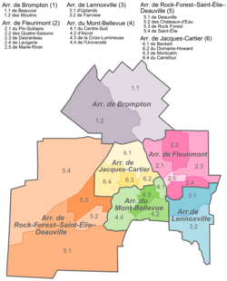
Rock Forest–Saint-Élie–Deauville is an arrondissement, or borough, of the city of Sherbrooke, Quebec.
Fleurimont is an arrondissement, or borough, of the city of Sherbrooke, Quebec, Canada on the Saint-François River. The borough comprises the former city of Fleurimont and the eastern portion of pre-amalgamation Sherbrooke.

Ville-Marie is the name of a borough (arrondissement) in the centre of Montreal, Quebec. The borough is named after Fort Ville-Marie, the French settlement that would later become Montreal, which was located within the present-day borough. Old Montreal is a National Historic Site of Canada.

Le Plateau-Mont-Royal is a borough (arrondissement) of the city of Montreal, Quebec, Canada.

Anjou is a borough (arrondissement) of the city of Montreal. Prior to its 2002 merger it was a city known as Ville d'Anjou.

Le Moyne is a neighbourhood in Longueuil, Quebec, part of the borough of Le Vieux-Longueuil, and a former city. Le Moyne makes up 2% of the total area of Le Vieux-Longueuil borough and is the only neighbourhood of the borough that was not part of the pre-2002 city of Longueuil. Residents of Le Moyne are called Le Moynois.

Mont-Bellevue is an arrondissement, or borough, of the city of Sherbrooke, Quebec. The borough comprises the former town of Ascot and the southern portion of pre-amalgamation Sherbrooke.
Brompton is a borough of the city of Sherbrooke, Quebec. The borough comprises the former city of Bromptonville, which was amalgamated into the city of Sherbrooke on January 1, 2002. Prior to December 30, 1998, "Brompton" referred to a township municipality which occupied some of the territory of the modern-day borough of Brompton.

Saint Denis Street is a major north–south thoroughfare in Montreal, Quebec.

Montreal-South was a suburb of Montreal located on the south shore of the St. Lawrence River founded in 1906. Montréal-Sud was created from land of the Saint-Antoine-de-Longueuil parish. Originally a village in its first five years, Montréal-Sud gained the status of city in 1911.
Sherbrooke is a provincial electoral district in the Estrie region of Quebec, Canada. It comprises the Jacques-Cartier and Mont-Bellevue boroughs of the city of Sherbrooke.

Le Vieux-Longueuil is a borough in the city of Longueuil.
Ville Jacques-Cartier was a city located on the south shore of Montreal, Quebec, Canada. It was named after the founder of New France, Jacques Cartier. Now a defunct city, its former territory makes up a third of the city of Longueuil and more than 80% of Le Vieux-Longueuil borough.

Sherbrooke Street is a major east–west artery and at 31.3 kilometres (19.4 mi) in length, is the second longest street on the Island of Montreal. The street begins in the town of Montreal West and ends on the extreme tip of the island in Pointe-aux-Trembles, intersecting Gouin Boulevard and joining up with Notre-Dame Street. East of Cavendish Boulevard this road is part of Quebec Route 138.
There are some hypotheses concerning the origin of the name of Montreal. The best-known is that it is a variant of "Mount Royal".

The Sainte-Marie neighbourhood is located in the eastern edge of the Centre-Sud in the borough of Ville-Marie. The Jacques Cartier Bridge and Maison Radio-Canada overlook the neighbourhood.

La Cité-Limoilou is the central borough of Quebec City, the oldest, and the most populous, comprising 21.85% of the city's total population. As an administrative division, it is very new, having only been formed on November 1, 2009, from the former boroughs of La Cité and Limoilou.
Mont Bellevue is a peak standing 333 m (1,093 ft), situated in a public park located in the borough of Mont-Bellevue in Sherbrooke, Quebec. The park also covers Mont Bellevue's parent peak, Mont John-S.-Bourque(elevation: 365 m ), as well as 200 ha of land, 30 km (19 mi) of trails, and several different types of ecosystems. Claiming 20% of the total park land, it is the largest park in Sherbrooke.