Sherbrooke is a city in southern Quebec, Canada. It is at the confluence of the Saint-François and Magog rivers in the heart of the Estrie administrative region. Sherbrooke is also the name of a territory equivalent to a regional county municipality (TE) and census division (CD) of Quebec, coextensive with the city of Sherbrooke. With 161,323 residents at the Canada 2016 Census, It is the sixth largest city in the province and the 30th largest in Canada. The Sherbrooke Census Metropolitan Area had 212,105 inhabitants, making it the fourth largest metropolitan area in Quebec and 19th in Canada.

The Estrie is an administrative region of Quebec that replaced the Eastern Townships. Estrie, a French neologism, was coined as a derivative of est, "east". Originally settled by anglophones, today it is about 90 per cent francophone. Anglophones are concentrated in Lennoxville, home of the region's only English-speaking university, Bishop's University. The Eastern Townships School Board runs 20 elementary schools, three high schools, and a learning centre.

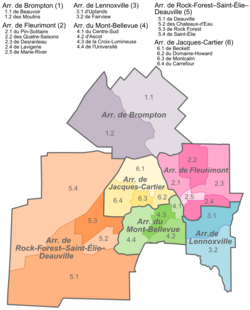
Lennoxville is an arrondissement, or borough, of the city of Sherbrooke, Quebec, Canada. Lennoxville is located at the confluence of the St. Francis and Massawippi Rivers approximately five kilometres south of downtown Sherbrooke.

Rock Forest–Saint-Élie–Deauville is an arrondissement, or borough, of the city of Sherbrooke, Quebec.
Fleurimont is an arrondissement, or borough, of the city of Sherbrooke, Quebec, Canada on the Saint-François River. The borough comprises the former city of Fleurimont and the eastern portion of pre-amalgamation Sherbrooke.

Le Plateau-Mont-Royal is a borough (arrondissement) of the city of Montreal, Quebec, Canada.
Brompton is a borough of the city of Sherbrooke, Quebec. The borough comprises the former city of Bromptonville, which was amalgamated into the city of Sherbrooke on January 1, 2002. Prior to December 30, 1998, "Brompton" referred to a township municipality which occupied some of the territory of the modern-day borough of Brompton.

Saint Denis Street is a major north–south thoroughfare in Montreal, Quebec.

CKOY-FM is a French-language Canadian radio station located in Sherbrooke, Quebec.
CFGE-FM is a French-language Canadian radio station located in Sherbrooke, Quebec. The station airs an adult contemporary format, and is part of the Rythme FM network which operates across much of Quebec. The station's transmitter is located at Mount Bellevue.

Route 216 is a two-lane east/west highway in Quebec, Canada, which starts in Sainte-Catherine-de-Hatley in the Estrie region at the junction of Route 108 and ends in Sainte-Perpétue in Chaudière-Appalaches at the junction of Route 204.
Catherine Island is an island in the Alexander Archipelago of southeastern Alaska, United States. It is part of the City and Borough of Sitka and lies just off the northeast corner of Baranof Island, separated from it by Portage Arm. The U.S. Forest Service named Catherine Island in 1935 after Catherine I of Russia. Catherine Island has a land area of 86.936 km2 and no resident population.

Hochelaga-Maisonneuve is a provincial electoral district in Quebec, Canada, that elects members to the National Assembly of Quebec. The district is located within Montreal, and its territory mostly covers the borough of Mercier–Hochelaga-Maisonneuve, and also parts of Rosemont–La Petite-Patrie, Ville-Marie and Le Plateau-Mont-Royal boroughs. It is bordered to the east by the Canadian National Railway yard, to the south by the Saint Lawrence River, to the north by Rachel and Sherbrooke Streets and to the west by Frontenac Street.
Saint-François is a provincial electoral district in the Estrie region of Quebec, Canada that elects members to the National Assembly of Quebec. It notably icludes parts of the city of Sherbrooke as well as the municipalities of Coaticook and Compton.
Sherbrooke is a provincial electoral district in the Estrie region of Quebec, Canada. It comprises the Jacques-Cartier and Mont-Bellevue boroughs of the city of Sherbrooke.

Sherbrooke Street is a major east–west artery and at 31.3 kilometres (19.4 mi) in length, is the second longest street on the Island of Montreal. The street begins in the town of Montreal West and ends on the extreme tip of the island in Pointe-aux-Trembles, intersecting Gouin Boulevard and joining up with Notre-Dame Street. East of Cavendish Boulevard this road is part of Quebec Route 138.
The city of Sherbrooke, Quebec is divided into six boroughs, each with a president and council.
Mont-Bellevue may refer to:
Jacques-Cartier is an arrondissement, or borough, of the city of Sherbrooke, Quebec. The borough comprises the portion of pre-amalgamation Sherbrooke located north of the Magog River. It contains the Carrefour de l'Estrie shopping centre and the Bois Beckett Park, one of few old-growth forests in the region.

Mont Bellevue is a peak standing 333 m (1,093 ft), situated in a public park located in the borough of Mont-Bellevue in Sherbrooke, Quebec. The park also covers Mont Bellevue's parent peak, Mont John-S.-Bourque(elevation: 365 m ), as well as 200 ha of land, 30 km (19 mi) of trails, and several different types of ecosystems. Claiming 20% of the total park land, it is the largest park in Sherbrooke.