Related Research Articles

Monterey County, officially the County of Monterey, is a county located on the Pacific coast of the U.S. state of California. As of the 2010 census, the population was 415,057. The county seat and largest city is Salinas.
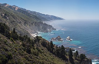
Big Sur is a rugged and mountainous section of the Central Coast of California between Carmel Highlands and San Simeon, where the Santa Lucia Mountains rise abruptly from the Pacific Ocean. It is frequently praised for its dramatic scenery. Big Sur has been called the "longest and most scenic stretch of undeveloped coastline in the contiguous United States," a "national treasure that demands extraordinary procedures to protect it from development" and "one of the most beautiful coastlines anywhere in the world, an isolated stretch of road, mythic in reputation." The stunning views, redwood forests, hiking, beaches, and other recreational opportunities have made Big Sur a popular destination for about 7 million people who live within a day's drive and visitors from across the world. It is among the top 35 tourist destinations world-wide. The region receives about the same number of visitors as Yosemite National Park, but offers extremely limited bus service, few restrooms, and a narrow two-lane highway with few places to park alongside the road. North-bound traffic during the peak summer season and holiday weekends is often backed up for about 20 miles (32 km) from Big Sur Village to Carmel.

The Central Coast is an area of California, United States, roughly spanning the coastal region between Point Mugu and Monterey Bay. It lies northwest of Los Angeles County and south of San Mateo and Santa Clara counties. From south to north, there are six counties that make up the Central Coast: Ventura, Santa Barbara, San Luis Obispo, Monterey, San Benito, and Santa Cruz.

Andrew Molera State Park is a relatively undeveloped state park on the Big Sur coast of California, United States, preserving land as requested by former owner Frances Molera. Situated at the mouth of the Big Sur River, the property was part of the Rancho El Sur land grant, and later owned by Californio pioneer John Bautista Rogers Cooper and his descendants. Cooper's grandchildren Andrew and Frances Molera inherited the property from their mother in 1918. Andrew popularized the artichoke in California in 1922, and died in 1931. In 1965, Frances sold the property to The Nature Conservancy, stipulating that the park to be created should be named for her brother.

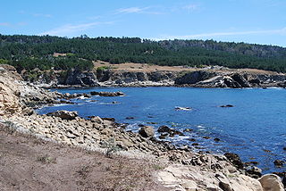
Point Lobos and the Point Lobos State Natural Reserve is the "crown jewel" of California's 280 state parks. Australian-born landscape artist Francis McComas described the point as the "greatest meeting of land and water in the world." Adjoining Point Lobos is "one of the richest marine habitats in California." The ocean habitat is protected by two marine protected areas, the Point Lobos State Marine Reserve and Point Lobos State Marine Conservation Area. The sea near Point Lobos is considered one the best locations for scuba diving on the Monterey Peninsula and along the California coast.
McGrath State Beach is a protected beach park located on the south bank of the mouth of Santa Clara River in the city of Oxnard, California. McGrath State Beach is one of the best bird-watching areas in California, with the lush riverbanks of the Santa Clara River and sand dunes along the shore. A nature trail leads to the Santa Clara Estuary Natural Preserve. Camping sites are available. Two miles of beach provide surfing and fishing opportunities. Just south of the station is the undeveloped Mandalay Beach Park which is about a mile downcoast beach walk from the park or a bike ride along Harbor Blvd. Located south of Ventura on Harbor Boulevard, the beach is on the Pacific Coast Bicycle Route and the California Coastal Trail.
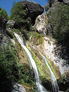
Salmon Creek Falls is a 120-foot waterfall in the southern Big Sur area, Monterey County, California. They are near Gorda, in the Santa Lucia Range and within the Monterey Ranger District of the Los Padres National Forest.

Middleton Beach is a coastal suburb of Albany, Western Australia, located within the City of Albany approximately 4 kilometres (2.5 mi) east of the city centre. The traditional owners, the Noongar peoples, know the place as Binalup meaning the place of first light since the sun rises over the waters in the morning. The main road between the city and the locality is via Middleton Road. It is home to a caravan park and numerous holiday units which provide accommodation for visitors to the Albany region.

Garrapata State Park is a state park of California, USA, located on California State Route 1 6.7 miles (10.8 km) south of Carmel and 18 miles (29 km) north of Big Sur Village on the Monterey coast. It is marked only with one sign on the west side of the road. Numbered turnouts mark each parking area. The 2,939-acre (1,189 ha) park was established in 1979.

McWay Falls is an 80-foot-tall (24 m) waterfall on the coast of Big Sur in central California that flows year-round from McWay Creek in Julia Pfeiffer Burns State Park, about 37 miles (60 km) south of Carmel, into the Pacific Ocean. During high tide, it is a tidefall. The only other tidefall in California is Alamere Falls.

William Randolph Hearst Memorial State Beach is located near the historic town of San Simeon along California State Route 1, in San Luis Obispo County, California, United States. It is named for newspaper magnate William Randolph Hearst (1863–
Gerstle Cove State Marine Reserve (SMR) is a marine protected area that lies onshore from Salt Point State Park, within the Salt Point State Marine Conservation Area, in Sonoma County on California’s north central coast. The marine protected area covers 0.1 square miles. Gerstle Cove SMR prohibits the take of all living resources.

Stewarts Point State Marine Reserve (SMR) and Stewarts Point State Marine Conservation Area (SMCA) are two adjoining marine protected areas that extend offshore from about a mile south of Black Point to Fisk Mill Cove, in Sonoma County on California’s north central coast. The marine protected areas cover 25.22 square miles. Stewarts Point SMR prohibits the take of all living marine resources. Stewarts Point SMCA prohibits the take of all living marine resources, except recreational shore based take of marine aquatic plants, marine invertebrates, finfish by hook and line, surf smelt by beach net, and species authorized by Title 14 Section 28.80 by hand-held dip net.
Salt Point State Marine Conservation Area (SMCA) is a marine protected area that lies onshore from Fisk Mill Cove and south along Salt Point State Park in Sonoma County on California’s north central coast. The marine protected area covers 3.12 square miles. Salt Point SMCA prohibits the take of all living marine resources, except the recreational take of abalone and finfish.
Little River State Beach is a protected beach of California, United States, in Humboldt County. It is located at the mouth of the Little River, 13 miles (21 km) north of Eureka right off U.S. Route 101. The 152-acre (62 ha) park was established in 1931.

Rancho San José y Sur Chiquito was a 8,876-acre (35.92 km2) Mexican land grant in present-day Big Sur, in Monterey County, California, given in 1835 to Teodoro Gonzalez and re-granted by Governor Juan Alvarado the same year to Marcelino Escobar. The grant, including Point Lobos, was located south of the Carmel River, extending inland along the coastal mountains, and south along the Pacific coast. It included San Jose Creek, Malpaso Creek, Soberanes Creek, Tres Pinos Creek, Garrapata Creek, and ended on the north side of Palo Colorado Canyon. The map drawn c. 1853 indicated a road or trail was already present along the coast.

Ragged Point is a headland on California's Central Coast. It is located at the southern end of Big Sur in northern San Luis Obispo County. The Ragged Point Inn and Resort is located in the area, which, as with much of Big Sur, features seaside cliffs, beaches, and hiking trails.

Big Sur Coast Highway is a section of California State Route 1 through the Big Sur region of California that is widely considered to be one of the most scenic driving routes in the United States, if not the world. It was the first California Scenic Highway and the first federal All American Road. It has been compared to the Amalfi Coast of Italy, the rugged scenic north coast of Taiwan, and roadways in the Andes. Condé Nast Traveler named State Route 1 through Big Sur one of the top 10 world-famous streets, comparable to Broadway in New York City and the Champs-Élysées in Paris.
The Southern Redwood Botanical Area is a 17 acres (6.9 ha) ecological preserve in the southern region of Big Sur in Monterey County, California. It contains the southernmost naturally occurring Redwood. The trees are located in the Little Redwood Gulch watershed adjacent to the Silver Peak Wilderness. The area is just north of the Salmon Creek trailhead.
Pfeiffer Beach is located in the Big Sur region of California. It is one of the most popular beaches on the Central Coast and is well known for Keyhole Rock, a popular photography subject. On a limited number of days in December and January each year, photographers crowd the beach to obtain pictures of the setting sun visible through the arch. Due to the steep terrain prevalent along the Big Sur coast, it one of the few ocean access points within Big Sur
References
- ↑ "Beaches". Big Sur Chamber of Commerce. Retrieved 29 August 2015.
- ↑ "Sand Dollar Beach & Jade Cove". California's Best Beaches. Retrieved 29 August 2015.
- ↑ "Big Sur Beaches". See Monterey. Retrieved 29 August 2015.
