
State Route 1 (SR 1) is a major north–south state highway that runs along most of the Pacific coastline of the U.S. state of California. At 656 miles (1,056 km), it is the longest state route in California, and the second-longest in the US after Montana Highway 200. SR 1 has several portions designated as either Pacific Coast Highway (PCH), Cabrillo Highway, Shoreline Highway, or Coast Highway. Its southern terminus is at Interstate 5 (I-5) near Dana Point in Orange County and its northern terminus is at U.S. Route 101 (US 101) near Leggett in Mendocino County. SR 1 also at times runs concurrently with US 101, most notably through a 54-mile (87 km) stretch in Ventura and Santa Barbara counties, and across the Golden Gate Bridge.

San Luis Obispo County, officially the County of San Luis Obispo, is a county on the Central Coast of California. As of the 2020 census, the population was 282,424. The county seat is San Luis Obispo.
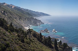
Big Sur is a rugged and mountainous section of the Central Coast of the U.S. state of California, between Carmel Highlands and San Simeon, where the Santa Lucia Mountains rise abruptly from the Pacific Ocean. It is frequently praised for its dramatic scenery. Big Sur has been called the "longest and most scenic stretch of undeveloped coastline in the contiguous United States", a sublime "national treasure that demands extraordinary procedures to protect it from development", and "one of the most beautiful coastlines anywhere in the world, an isolated stretch of road, mythic in reputation". The views, redwood forests, hiking, beaches, and other recreational opportunities have made Big Sur a popular destination for visitors from across the world. With 4.5 to 7 million visitors annually, it is among the top tourist destinations in the United States, comparable to Yosemite National Park, but with considerably fewer services, and less parking, roads, and related infrastructure.

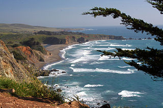
The Central Coast is an area of California, roughly spanning the coastal region between Point Mugu and Monterey Bay. It lies northwest of Los Angeles and south of the San Francisco Bay Area, and includes the rugged, rural, and sparsely populated stretch of coastline known as Big Sur.

Point Mugu is a cape or promontory within Point Mugu State Park on the Pacific Coast in Ventura County, near the city of Port Hueneme and the city of Oxnard. The name is believed to be derived from the Chumash Indian term "Muwu", meaning "beach", which was first mentioned by Cabrillo in his journals in 1542. Mugu Lagoon is a salt marsh just upcoast from the promontory within the Naval Base Ventura County formerly called the Naval Air Station Point Mugu.

The Santa Lucia Mountains or Santa Lucia Range is a rugged mountain range in coastal central California, running from Carmel southeast for 140 miles (230 km) to the Cuyama River in San Luis Obispo County. The range is never more than 11 miles (18 km) from the coast. The range forms the steepest coastal slope in the contiguous United States. Cone Peak at 5,158 feet (1,572 m) tall and three miles (5 km) from the coast, is the highest peak in proximity to the ocean in the lower 48 United States. The range was a barrier to exploring the coast of central California for early Spanish explorers.

Guadalupe-Nipomo Dunes is the largest remaining dune system south of San Francisco and the second largest in the U.S. state of California. It encompasses an 18-mile (29 km) stretch of coastline on the Central Coast of California and extends from southern San Luis Obispo County to northern Santa Barbara County.

Montaña de Oro is a state park in Central Coastal California, six miles southwest of Morro Bay and two miles south of Los Osos.

The California Coastal National Monument is located along the entire coastline of the U.S. state of California. This monument ensures the protection of all islets, reefs and rock outcroppings along the coast of California within 12 nautical miles (22 km) of shore along the entire 840-mile (1,350 km) long coastline. Conservative estimates are for at least 20,000 such outcroppings. The monument was created by Bill Clinton via Presidential proclamation on January 11, 2000, with the authority in section two of the Antiquities Act of 1906. As of 2014, the monument has expanded to 2,272 acres (919 ha). The U.S. Bureau of Land Management, an agency of the U.S. Department of the Interior that manages the monument, has developed gateways in cooperation with other agencies along the California coast to introduce the monument to the public. These include the Trinidad, Point Arena, Fort Bragg-Mendocino, Pigeon Point Lighthouse, Piedras Blancas State Marine Reserve and Marine Conservation Area, and the Palos Verdes Peninsula. Although being the most-viewed national monument in California, people are usually unaware that the entire coastline is a national monument.
San Carpóforo Creek flows through San Carpóforo Canyon and into the Pacific Ocean in a small bay 20 miles (32 km) north of San Simeon on the Central Coast of California. The creek is generally considered to be the southern border of the Big Sur region of Central California.
Garrapata State Park is a state park of California, United States, located on California State Route 1 6.7 miles (10.8 km) south of Carmel-by-the-Sea and 18 miles (29 km) north of Big Sur Village on the Monterey coast. The 2,939-acre (1,189 ha) park was established in 1979. California sea lions, harbor seals and sea otters frequent the coastal waters while gray whales pass close by during their yearly migration.

MacKerricher State Park is a state park in California in the United States. It is located 3 miles (4.8 km) north of Fort Bragg in Mendocino County. It covers 9 miles (14 km) of coastline and contains several types of coastal habitat, including beaches, dunes, headlands, coves, wetlands, tide pools, forest, and a freshwater lake.

McWay Falls is an 80-foot-tall (24 m) waterfall on the coast of Big Sur in central California that flows year-round from McWay Creek in Julia Pfeiffer Burns State Park, about 37 miles (60 km) south of Carmel, into the Pacific Ocean. During high tide, it is a tidefall, a waterfall that empties directly into the ocean. The only other tidefall in California is Alamere Falls.

William Randolph Hearst Memorial State Beach is located near the historic town of San Simeon along California State Route 1, in San Luis Obispo County, California, United States. It is named for newspaper magnate William Randolph Hearst (1863–1951), whose family is closely associated with the area.

The Land Conservancy of San Luis Obispo County (LCSLO) is a non-profit land trust organization that has been operating in San Luis Obispo County, California since 1984. The LCSLO is dedicated to the voluntary and collaborative preservation and improvement of lands that hold significant scenic, agricultural, habitat, and cultural values. Their work aims to benefit both the local community and wildlife that depends on these lands.
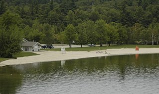
Mount Sunapee State Park is a public recreation area in Newbury, New Hampshire. The state park's nearly 3,000 acres (1,200 ha) include most of Mount Sunapee and a beach area on Lake Sunapee. Park activities include swimming, hiking, camping, skiing, fishing, picnicking, and non-motorized boating. The park's ski area is operated as Mount Sunapee Resort under the management of Vail Resorts Inc.
Big Sur Coast Highway is a section of California State Route 1 through the Big Sur region of California that is widely considered to be one of the most scenic driving routes in the United States, if not the world. It is both a National Scenic Highway and a California Scenic Highway, and was described by Australian painter Francis McComas as the "greatest meeting of land and water in the world". Condé Nast Traveler named State Route 1 through Big Sur one of the top ten world-famous streets, comparable to Broadway in New York City and the Champs-Élysées in Paris. The road itself is a destination for visitors.
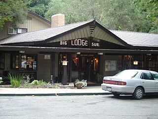
Big Sur Village is an unincorporated community in the Big Sur region, in Monterey County, California, United States. It is located along a 1-mile-long (1.6 km) stretch of Big Sur Coast Highway in the Big Sur Valley 24 miles (39 km) south of Carmel, California. The village contains the largest collection of shops and visitor services along the entire 71-mile (114 km) segment of California State Route 1 between Malpaso Creek near Carmel Highlands in the north and San Carpóforo Creek near San Simeon in the south. The population of the entire coastal region is about 1,463. The collection of small roadside businesses and homes is often confused with the larger region, also known as Big Sur. On March 6, 1915, United States Post Office granted the English-speaking residents' request to change the name of their post office from Arbolado to Big Sur. Caltrans also refers to the village as Big Sur.
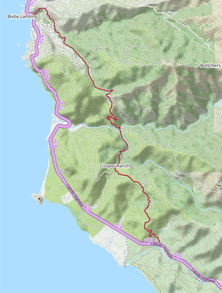
The Old Coast Road is a dirt road that still exists in part and preceded the current Big Sur Coast Highway along the northern coast of Big Sur, California. It was initially a trail created by Rumsen and Esselen Native Americans to travel along the coast in present-day Monterey County, California. Soon after the Spanish arrived, Governor Teodoro Gonzalez granted land that included portions of the trail as Rancho San Jose y Sur Chiquito to Marcelino Escobar in 1835. Governor Juan Alvarado re-granted the land to Escobar the same year. The Rancho included land from Carmel to near Palo Colorado Canyon. José Castro gained possession of the land in about 1848. He improved the trail from Monterey to Palo Colorado Canyon as early as 1853. A hand-drawn map created c. 1853 accompanying the grant indicated a road or trail was already present along the coast.
