Jagdishpur, Sultanpur

Last updated

Jagdishpur
Jagdīspur
Town
Jagdishpur block map (Sultanpur).png
Map showing Jagdishpur CD block
India Uttar Pradesh location map.svg
Red pog.svg
Jagdishpur
Location in Uttar Pradesh, India
Coordinates: 26°27′23″N81°37′08″E / 26.456357°N 81.618961°E / 26.456357; 81.618961 [1]
CountryFlag of India.svg  India
State Uttar Pradesh
Division Faizabad division
District Amethi
Elevation
70 m (230 ft)
Languages
  Official Hindi, Urdu
Time zone UTC+5:30 (IST)
Websitewww.upgov.in

Jagdishpur is a town, [2] community development block, [3] and former pargana in Musafirkhana tehsil of Amethi district, Uttar Pradesh, India. [3] [2] It is also called Nihalgarh, Chak Jangla, or Nihalgarh-Jagdispur. [2] The distinction is that Jagdishpur was the original village, Chak Jangla was an outlying hamlet of Jagdishpur, and Nihalgarh was a fort built in Chak Jangla in the early 1700s and that no longer exists. [2] The town is located at the crossroads between the Lucknow-Jaunpur and Raebareli-Faizabad highways. [2]

Contents

History

Jagdishpur was originally named after a Brahmin zamindar named Jagdis who lived at the time when the area was ruled by the Bhars. [2] In 1715, the Bhale Sultan leader Nihal Khan established a fort at the outlying hamlet of Chak Jangla. [2] He named the fort Nihalgarh after himself, and a town sprang up around it that came to eclipse Jagdishpur proper. [2] In 1750, the tehsildar Mirza Latif Beg besieged and captured Nihalgarh; he then made it his residence. [2] Up to that time, there had been two parganas in the area at Kishni and Sathin (or Satanpur), but either Nihal Khan or Mirza Latif Beg united the two parganas into one based at Jagdishpur. [2] Sometime after 1750 but before the 20th century, the fort of Nihalgarh was torn down. [2]

At the turn of the 20th century, the town of Jagdishpur/Nihalgarh had a police station, a middle vernacular school with about 150 students, and a registration office located at the Gulabganj sarai. [2] It also had a small bazar, which mostly dealt in everyday goods like food and clothing, as well as brass vessels made by the Thatheras. [2] There was only one masonry house, which had been built by a wealthy Agarwal Bania named Balmukand who had acquired a small estate by purchase and mortgage. [2] Balmukand's successor, Bibi Rampiari, owned seven villages and two pattis in the area at the time. [2] As of 1901, the population of the town was 2,121 people, including 1,168 Muslims. [2]

The 1951 census recorded Jagdishpur as having a district board-run primary school, with 197 students in attendance as of 1 January of the year. [4]

The 1961 census recorded Jagdishpur as having a police force of 2 sub-inspectors, 1 head constable, and 14 constables. [5] It had a dispensary run by a local body with 12 male beds and 8 female beds, a maternity and child welfare centre, and a post office. [5] Average attendance of the Dussehra festival was about 1,500 people then. [5]

Villages

Jagdishpur CD block has the following 91 villages: [3]

Village nameTotal land area (hectares)Population (in 2011)
Banbhariya 756.94,800
Sitauli 358.82,338
Dhudehri 326.93,087
Rajkheta 108725
Palia Paschim 477.83,541
Koilesh Mubaraqpur 499.33,841
Sendurwa 4945,506
Kamrauli 396.34,453
Utelwa 429.22,552
Niyawa 209.92,760
Sarai Alam 120.9652
Ankara 70.6701
Shahpur Allad Husain 107.3793
Mangrauli 971,783
Bagmira 1081,255
Rasta Mau 274.73,943
Lakhanipur 155.41,817
Daulatpur Nisura 358.93,169
Pure Moti Shukul 30.2366
Mirapur 199.51,058
Gadriya Dih 314.54,187
Deokali 269.84,602
Mau Atwara 554.64,551
Makhdum Pur 117.8865
Nihal Pur 82.61,525
Mohuddinpur 70.8854
Katehti 237.52,658
Ashrafpur 86.11,224
Matiyari Kalan 207.61,165
Pichhuti 421.42,686
Nasirabad 128.5870
Kachnaaw 530.24,989
Thauri 731.46,916
Dichauli 503.34,346
Alinagar 80.31,024
Purab Gaon 224.82,680
Jalalpur Mafi 79.6691
Bhikhanpur 66.71,643
Daulatpur Lonhat 407.56,910
Moh Mau 390.14,412
Husain Ganj Kalan 480.24,009
Namadar Pur 46.8722
Kaima 307.62,332
Imli Gaon 373.94,386
Bechu Garh 163.61,237
Tanda 558.95,851
Khairatpur 183.22,278
Parwej Pur 126.51,039
Mangauli 359.42,866
Sohrat Singh 27.51,175
Ranka Pur 76.3835
Mohabbat Pur 353.92,341
Misharauli 269.22,120
Bagahi 258.12,292
Sindhiyawan 466.87,418
Arifpur 23.7296
Loshan Pur 90.8461
Garha 83.7874
Malawa 113.31,496
Mangraura 128.61,585
Sarai Hetan 42.3447
Dulari Nagar 835.82,846
Jalal Pur Tiwari 362.43,588
Urwa 135.11,047
Nisura 205.92,283
Mirapur Nisura 41.6288
Mubarakpur 102.41,658
Maraucha Tetarpur 236.31,216
Uttar Gaon 305.13,272
Siryari 119.91,094
Saresar 176.82,971
Mohammad Pur 108.6701
Kapuripur 102.81,235
Purab Gaon 89.7779
Badhauli 215.62,111
Mudupur Umraula 3812,938
Naudand 328.62,948
Rampur Gosai 55.7473
Babu Pur Sharia 180.42,672
Khau Pur 148.4761
Shesh Pur 981,315
Hasawa Sukhn Pur 165.41,721
Hasan Pur Jareye 78.5338
Itraur 204.42,105
Dakkhin Gaon Mau 323.13,443
Harimau 246.74,001
Gunge Mau 195.41,893
Gaimau 255.61,617

Related Research Articles

<span class="mw-page-title-main">Sultanpur district</span> District of Uttar Pradesh in India

Sultanpur district is a district in the Awadh region of the Indian state of Uttar Pradesh. This district is a part of Ayodhya division in Uttar Pradesh. The administrative headquarters of the district is Sultanpur city. The total area of Sultanpur district is 2672.89 Sq. km.

<span class="mw-page-title-main">Gosainganj, Lucknow</span> Town in Uttar Pradesh, India

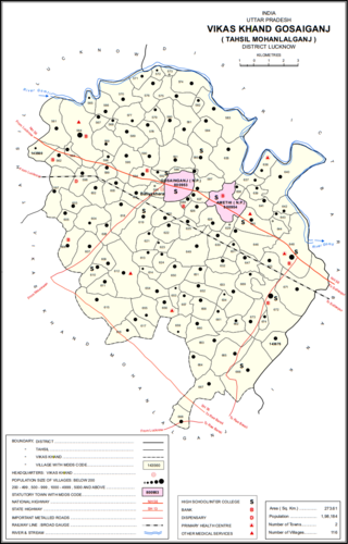
Gosainganj, also spelled Goshainganj or Gosaiganj is a town and nagar panchayat in Lucknow district of Uttar Pradesh, India. It is the seat of a community development block, which is included in the tehsil of Mohanlalganj. As of 2011, its population is 9,649, in 1,685 households. The starting point of the Purvanchal Expressway i.e. Chand Saray village is situated 2.5 km away from Gosainganj.

Jagdishpur is a town in Amethi in the Indian state of Uttar Pradesh.

<span class="mw-page-title-main">Ajgain</span> Village in Uttar Pradesh, India

Ajgain is a village in Nawabganj block of Unnao district, Uttar Pradesh, India. It is located northeast of Unnao, near the main Lucknow-Kanpur road. It has a railway station on the Lucknow-Kanpur line, lying between Sonik and Kusumbhi. It holds a market on Mondays and Fridays, with grain and vegetables being the main items of trade. As of 2011, the population of Ajgain is 8,926, in 1,481 households.

<span class="mw-page-title-main">Parsandan</span> Village in Uttar Pradesh, India

Parsandan is a village in Nawabganj block of Unnao district, Uttar Pradesh, India. It was historically the capital of a pargana, since at least the time of Akbar. As of 2011, its population is 3,946, in 778 households.

<span class="mw-page-title-main">Karanpur, Raebareli</span> Village in Uttar Pradesh, India

Karanpur is a village in Bachhrawan block of Rae Bareli district, Uttar Pradesh, India. Located 23 km from the city of Raebareli, Karanpur was historically one of the main villages in the Bachhrawan pargana. As of 2011, Karanpur's population is 4,171, in 791 households.

<span class="mw-page-title-main">Thulendi</span> Village in Uttar Pradesh, India

Thulendi is a village in Bachhrawan block of Rae Bareli district, Uttar Pradesh, India. It is located 6 km from Bachhrawan, the block headquarters, on an elevated plain with clayey soil. A historic village, Thulendi served as a pargana headquarters from the early 1400s until the late 1700s, and it has several old monuments including a fort built under the Jaunpur Sultanate and two large tanks othat are said to be even older. As of 2011, Thulendi's population is 6,616, in 1,195 households.

<span class="mw-page-title-main">Kumhrawan</span> Village in Uttar Pradesh, India

Kumhrawan is a village in Shivgarh block of Rae Bareli district, Uttar Pradesh, India. Formerly a pargana headquarters, it consists of a main village and several scattered hamlets. As of 2011, Kumhrawan has a population of 2,441, in 426 households.

<span class="mw-page-title-main">Inhauna</span> Village in Uttar Pradesh, India

Inhauna is a village and corresponding in Singhpur block of Rae Bareli district, Uttar Pradesh, India. As of 2011, its population is 13,049, in 2,021 households. Located at the junction of the Raebareli-Rudauli and Lucknow-Jaunpur roads, Inhauna is an old town that once served as the seat of a pargana as well as (briefly) a tehsil, and it has the ruins of an old fort built under the Nawabs of Awadh. The old marketplace, known as Ratanganj, was built in 1863 by the tahsildar Ratan Narain. Markets are held twice per week, on Mondays and Thursdays, and most of the trade is in livestock.

<span class="mw-page-title-main">Jagdishpur, Dih, Raebareli</span> Village in Uttar Pradesh, India

Jagdishpur is a village in Dih block of Rae Bareli district, Uttar Pradesh, India. It is located 21 km from Raebareli, the district headquarters. As of 2011, it has a population of 4,538 people, in 840 households. It belongs to the nyaya panchayat of Dih.

<span class="mw-page-title-main">Chak Gajraj</span> Village in Uttar Pradesh, India

Chak Gajraj is a village in Khiron block of Rae Bareli district, Uttar Pradesh, India. It is located 11 km from Lalganj, the tehsil headquarters. As of 2011, it has a population of 429 people, in 68 households. It has 1 primary school and no healthcare facilities and it does not host a weekly haat or a permanent market. It belongs to the nyaya panchayat of Semari.

<span class="mw-page-title-main">Chak Lodipur</span> Village in Uttar Pradesh, India

Chak Lodipur is a village in Rahi block of Rae Bareli district, Uttar Pradesh, India. It is located 8 km from Rae Bareli, the district headquarters. As of 2011, it has a total population of 449 people, in 89 households. It has one primary school and no medical facilities and it does not host a weekly haat or a permanent market. It belongs to the nyaya panchayat of Rustampur.

<span class="mw-page-title-main">Gaimau</span> Village in Uttar Pradesh, India

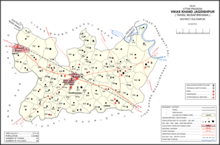
Gaimau is a village in Jagdishpur block of Sultanpur district, Uttar Pradesh, India. It is located 50 km from Sultanpur, the district headquarters. As of 2011, it has a population of 1,617 people, in 255 households. It has one primary school and no healthcare facilities and does not host a permanent market or weekly haat. It belongs to the nyaya panchayat of Harimau.

<span class="mw-page-title-main">Jaisinghpur, Sultanpur</span> Village in Uttar Pradesh, India

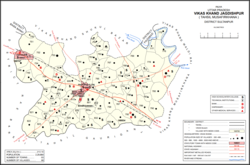
Jaisinghpur is a village and tehsil headquarters in Sultanpur district, Uttar Pradesh, India. As of 2011, it has a population of 2,211 people, in 353 households. It has 4 primary schools and one hospital. It hosts a haat on Tuesdays and Saturdays mostly dealing in tat patti. It serves as the headquarters of a nyaya panchayat which also includes 23 other villages. It is also the seat of a community development block, which was inaugurated in 1953.

<span class="mw-page-title-main">Jamo, Uttar Pradesh</span> Village in Uttar Pradesh, India

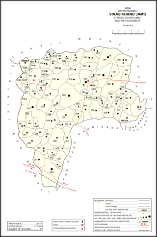
Jamo, also spelled Jamun or Jamon, is a village and community development block headquarters in Gauriganj tehsil of Amethi district, Uttar Pradesh, India. As of 2011, it has a population of 6,734 people, in 1,182 households. It was historically the capital of the pargana of Gaura Jamun. It is located at the intersection of four minor district roads, some of which are prone to flooding during the rainy season.

<span class="mw-page-title-main">Dakhinwara, Amethi</span> Village in Uttar Pradesh, India

Dakhinwara is a village in Jamo block of Amethi district, Uttar Pradesh, India. As of 2011, it has a population of 3,840 people, in 613 households. It has two primary schools and one maternity and child welfare centre and it hosts a weekly haat but not a periodic market. It belongs to the nyaya panchayat of Jamo.

<span class="mw-page-title-main">Gaura, Jamo</span> Village in Uttar Pradesh, India

Gaura is a village in Jamo block of Amethi district, Uttar Pradesh, India. The namesake of the historical pargana of Gaura Jamun, Gaura consists of a main site called Gaura khas in the northeast surrounded by several smaller hamlets. The village lands are fertile and contain many orchard groves. In the east-central part there is a large jhil which provides a convenient source of irrigation but also sometimes overflows and floods the surrounding fields. Gaura is located just north of Jamo on the Gauriganj-Jagdishpur road, and another road also leads off to Musafirkhana.

<span class="mw-page-title-main">Katari, Amethi</span> Village in Uttar Pradesh, India

Katari is a village in Jamo block of Amethi district, Uttar Pradesh, India. It is located by a stream called the Naiya or Kandu nala, which flows east toward the Gomti river. The main highway from Lucknow to Jaunpur passes further north. Katari was historically the seat of a taluqdari estate held by a leading branch of the Kanhpuria Rajputs.

<span class="mw-page-title-main">Baraulia</span> Village in Uttar Pradesh, India

Baraulia is a village in Jamo block of Amethi district, Uttar Pradesh, India. As of 2011, it has a population of 3,878 people, in 691 households. It has one primary school and no healthcare facilities and it hosts both a regular market and a weekly haat. It belongs to the nyaya panchayat of Hardo.

<span class="mw-page-title-main">Piparpur, Bhadar</span> Village in Uttar Pradesh, India

Piparpur is a village in Bhadar block of Amethi district, Uttar Pradesh, India. The historical capital of the pargana of Asal, Piparpur is located on the road from Amethi to Chanda, just west of the intersection with the main Allahabad-Faizabad road. Running through the village is a stream that originates in the Bhujwa jhil and flows into neighbouring Prataphgarh district where it joins with the Chamraura. The banks of this stream are well-wooded; they used to be more so, but a lot of it was cut down around the turn of the 20th century to provide materials for the railway. There is also some significant usar land, especially in the north of the village.

References

  1. "Geonames Search". Do a radial search using these coordinates here.
  2. 1 2 3 4 5 6 7 8 9 10 11 12 13 14 15 16 Nevill, H.R. (1903). Sultanpur: A Gazetteer, Being Volume XLVI Of The District Gazetteers Of The United Provinces Of Agra And Oudh. Allahabad: Government Press. pp. 183–6. Retrieved 13 November 2021.
  3. 1 2 3 "Census of India 2011: Uttar Pradesh District Census Handbook - Sultanpur, Part A (Village and Town Directory)" (PDF). Census 2011 India. pp. 94–111. Retrieved 13 November 2021.
  4. Census of India, 1951: District Census Handbook Uttar Pradesh (49 - Rae Bareli District) (PDF). Allahabad. 1955. p. 199. Retrieved 13 November 2021.{{cite book}}: CS1 maint: location missing publisher (link)
  5. 1 2 3 Census 1961: District Census Handbook, Uttar Pradesh (44 - Sultanpur District) (PDF). Lucknow. 1965. pp. 118, 121–2, 126, 128, 142–3. Retrieved 13 November 2021.{{cite book}}: CS1 maint: location missing publisher (link)