Baramadpur

Last updated

Baramadpur
Barāmadpur
Village
Akhand Nagar block map.png
Map showing Baramadpur (#191) in Akhand Nagar CD block
India Uttar Pradesh location map.svg
Red pog.svg
Baramadpur
Location in Uttar Pradesh, India
Coordinates: 26°14′25″N82°39′32″E / 26.240391°N 82.658968°E / 26.240391; 82.658968 [1]
CountryFlag of India.svg  India
State Uttar Pradesh
Division Faizabad division
District Sultanpur
Area
[2]
  Total3.506 km2 (1.354 sq mi)
Population
 (2011) [2]
  Total3,251
  Density930/km2 (2,400/sq mi)
Languages
  Official Hindi, Urdu
Time zone UTC+5:30 (IST)

Baramadpur is a village in Akhand Nagar block of Kadipur tehsil in Sultanpur district of Uttar Pradesh, India. [2] As of 2011, it has a population of 3,251 people, in 442 households. [2] It has one primary school and one primary health centre and it hosts both a regular market and a weekly haat. [2] It is part of the nyaya panchayat of Sajampur. [3]

Located 58 km from Sultanpur, the district headquarters, [4] Baramadpur is surrounded by the Majhui River to the north, Nawab Yusuf Road to the east, the Faizabad-Shahganj-Jaunpur Railway line to the west, and Kalwaribandh village to the south. Baramadpur is 20 km from Shahganj and 27 km from Akbarpur on Nawab Yusuf Road. Although the village is part of Sultanpur district, its post office is linked to Ambedkar Nagar district.

Shri Kashi Ram Rashtriya Inter College is a government aided school in Baramadpur which is affiliated to UP Board is the main center of education in Baramadpur.

New upcoming Purvanchal Expressway is going to provide Baramadpur a faster connectivity to Lucknow, Azamgarh and Gorakhpur (via Gorakhpur Link Expressway). In Baramadpur Purvanchal Expressway is intersecting with NH 135A which connects Baramadpur to Ayodhya and Varanasi. Also Purvanchal Expressway is crossing Shahganj-Ayodhya railway line in Kalwari Bandh (near Tulsi Nagar railway station) and Rail over bridge is under construction. Uttar Pradesh Chief Minister Yogi Adityanath visited Kalwari Bandh on Feb 8th 2020 to inspect Purvanchal Expressway construction status.

Demographic history

The 1951 census recorded Baramadpur as comprising 2 hamlets, with a total population of 996 people (491 male and 505 female), in 158 households and 148 physical houses. [5] The area of the village was given as 892 acres. [5] 58 residents were literate, 52 male and 6 female. [5] The village was listed as belonging to the pargana of Aldemau and the thana of Dostpur. [5] It had a district-board run primary school with 63 students in attendance as of 1 January 1951. [5]

The 1961 census recorded Baramadpur as comprising 4 hamlets, with a total population of 1,144 people (577 male and 567 female), in 186 households and 174 physical houses.. [6] The area of the village was given as 892 acres. [6]

The 1981 census recorded Baramadpur as having a population of 1,733 people, in 252 households, and having an area of 361.40 hectares. [4] The main staple foods were listed as wheat and rice. [4]

The 1991 census recorded Baramadpur as having a total population of 2,141 people (1,049 male and 1,092 female), in 285 households and 271 physical houses. [3] The area of the village was listed as 346.12 hectares. [3] Members of the 0-6 age group numbered 437, or 20% of the total; this group was 50% male (218) and 50% female (219). [3] Members of scheduled castes numbered 636, or 30% of the village's total population, while no members of scheduled tribes were recorded. [3] The literacy rate of the village was 53% (606 men and 302 women, counting only people age 7 and up). [3] 470 people were classified as main workers (463 men and 7 women), while 28 people were classified as marginal workers (all women); the remaining 1,643 residents were non-workers. [3] The breakdown of main workers by employment category was as follows: 402 cultivators (i.e. people who owned or leased their own land); 27 agricultural labourers (i.e. people who worked someone else's land in return for payment); 0 workers in livestock, forestry, fishing, hunting, plantations, orchards, etc.; 0 in mining and quarrying; 4 household industry workers; 1 worker employed in other manufacturing, processing, service, and repair roles; 4 construction workers; 3 employed in trade and commerce; 5 employed in transport, storage, and communications; and 24 in other services. [3]

Related Research Articles

Bilariaganj is the second largest city and a Nagar Palika Parishad in Azamgarh division after its capital city Azamgarh in the state of Uttar Pradesh, India.

<span class="mw-page-title-main">Akbarpur, Ambedkar Nagar</span> City in Uttar Pradesh, India

Akbarpur is a city, municipal corporation, tehsil, and the administrative headquarters of Ambedkar Nagar district in the state of Uttar Pradesh, India. It is a part of Ayodhya division.

<span class="mw-page-title-main">Nawab Yusuf Road</span> Road in Uttar Pradesh, India

Nawab Yusuf Road is situated in the Indian state of Uttar Pradesh, it connects Jaunpur to Ayodhya via Shahganj and Akbarpur.

Rajesultanpur or Raje Sultanpur is a town and nagar panchayat in Ambedkar Nagar district in the Indian state of Uttar Pradesh.

National Highway 135A, commonly referred to as NH 135A is a national highway in India. It is a secondary route of National Highway 35. NH-135A runs in the state of Uttar Pradesh in India. बमयय

<span class="mw-page-title-main">Sultanpur Khera</span> Village in Uttar Pradesh, India

Sultanpur Khera is a village in Sataon block of Rae Bareli district, Uttar Pradesh, India. As of 2011, its population is 7,619, in 1,384 households. It has 4 primary schools and no healthcare facilities. Sultanpur Khera hosts two festivals: one is dedicated to Parvin Devi and takes place on Chaitra Sudi 9, and the other is dedicated to Purvi Devi and takes place on Asvina Sudi 9. Vendors bring earthenware pottery, bangles, and various everyday items to sell at both festivals.

<span class="mw-page-title-main">Kahinjar</span> Village in Uttar Pradesh, India

Kahinjar is a village in Sareni block of Rae Bareli district, Uttar Pradesh, India. It is located 20 km from Lalganj, the tehsil headquarters. Kahinjar historically served as the headquarters of a mahal since at least the time of Akbar, before being merged into the pargana of Sareni under the Nawabs of Awadh. As of 2011, Kahinjar has a population of 2,099 people, in 354 households. It has one primary school and no healthcare facilities. It belongs to the nyaya panchayat of Rasulpur.

<span class="mw-page-title-main">Dudhwan</span> Village in Uttar Pradesh, India

Dudhwan is a village in Sareni block of Rae Bareli district, Uttar Pradesh, India. It is located 21 km from Lalganj, the tehsil headquarters. As of 2011, it has a population of 2,638 people, in 408 households. It belongs to the nyaya panchayat of Raipur.

<span class="mw-page-title-main">Sultanpur Jala</span> Village in Uttar Pradesh, India

Sultanpur Jala is a village in Dalmau block of Rae Bareli district, Uttar Pradesh, India. As of 2011, it has a population of 839 people, in 157 households. It has one primary school and no healthcare facilities.

<span class="mw-page-title-main">Nisgar</span> Village in Uttar Pradesh, India

Nisgar is a village in Sareni block of Rae Bareli district, Uttar Pradesh, India. It is located on the bank of the Ganges, 23 km from the tehsil headquarters at Lalganj. Nisgar is mentioned in the late 16th-century Ain-i-Akbari as the seat of a mahal in the sarkar of Lucknow. It was later merged into the pargana of Sareni under the Nawabs of Awadh in the 1700s.

<span class="mw-page-title-main">Singhaur Tara</span> Village in Uttar Pradesh, India

Singhaur Tara is a village in Sareni block of Rae Bareli district, Uttar Pradesh, India. It is located on the bank of the Ganges, 18 km from the tehsil headquarters at Lalganj. Singhaur Tara is probably identical with the mahal called "Tara Singhaur" Ain-i-Akbari in the late 16th century. This mahal was in the sarkar of Lucknow. It was later merged into the pargana of Sareni under the Nawabs of Awadh in the 1700s.

<span class="mw-page-title-main">Gaimau</span> Village in Uttar Pradesh, India

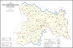
Gaimau is a village in Jagdishpur block of Sultanpur district, Uttar Pradesh, India. It is located 50 km from Sultanpur, the district headquarters. As of 2011, it has a population of 1,617 people, in 255 households. It has one primary school and no healthcare facilities and does not host a permanent market or weekly haat. It belongs to the nyaya panchayat of Harimau.

<span class="mw-page-title-main">Sajampur</span> Village in Uttar Pradesh, India

Sajampur is a village in Akhand Nagar block of Kadipur tehsil in Sultanpur district of Uttar Pradesh, India. As of 2011, it has a population of 1,749 people, in 246 households. It has one primary school and no healthcare facilities and it does not host a regular market or a weekly haat. It serves as the seat of a nyaya panchayat which also includes 13 other villages.

<span class="mw-page-title-main">Muradabad, Sultanpur</span> Village in Uttar Pradesh, India

Muradabad is a village in Akhand Nagar block of Kadipur tehsil in Sultanpur district, Uttar Pradesh, India. As of 2011, it has a population of 1,543 people, in 238 households. It has one primary school and no healthcare facilities and it hosts both a regular market and a weekly haat. It belongs to the nyaya panchayat of Sajampur.

<span class="mw-page-title-main">Karai, Sultanpur</span> Village in Uttar Pradesh, India

Karai is a village in Akhand Nagar block of Kadipur tehsil in Sultanpur district, Uttar Pradesh, India. As of 2011, it has a population of 1,399 people, in 196 households. It has one primary school and no healthcare facilities and it does not host a regular market or a weekly haat. It belongs to the nyaya panchayat of Sajampur.

<span class="mw-page-title-main">Raipur, Akhand Nagar</span> Village in Uttar Pradesh, India

Raipur is a village in Akhand Nagar block of Kadipur tehsil in Sultanpur district, Uttar Pradesh, India. As of 2011, it has a population of 1,738 people, in 307 households. It has one primary school and no healthcare facilities and it does not host a regular market or a weekly haat. It belongs to the nyaya panchayat of Sajampur.

<span class="mw-page-title-main">Ramnagar, Akhand Nagar</span> Village in Uttar Pradesh, India

Ramnagar is a village in Akhand Nagar block of Kadipur tehsil in Sultanpur district, Uttar Pradesh, India. As of 2011, it has a population of 983 people, in 144 households. It has no healthcare facilities and it does not host a regular market or a weekly haat. It belongs to the nyaya panchayat of Sajampur.

<span class="mw-page-title-main">Jaisinghpur, Sultanpur</span> Village in Uttar Pradesh, India

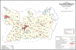
Jaisinghpur is a village and tehsil headquarters in Sultanpur district, Uttar Pradesh, India. As of 2011, it has a population of 2,211 people, in 353 households. It has 4 primary schools and one hospital. It hosts a haat on Tuesdays and Saturdays mostly dealing in tat patti. It serves as the headquarters of a nyaya panchayat which also includes 23 other villages. It is also the seat of a community development block, which was inaugurated in 1953.

<span class="mw-page-title-main">Shahgarh, Amethi</span> Village in Uttar Pradesh, India

Shahgarh is a village and community development block headquarters in Gauriganj tehsil of Amethi district, Uttar Pradesh, India. As of 2011, it has a population of 3,201 people, in 525 households. It historically was the seat of a taluqdari estate held by a branch of the Bandhalgoti Rajputs. Today it serves as the seat of a nyaya panchayat which also includes 13 other villages.

<span class="mw-page-title-main">Piparpur, Bhetua</span> Village in Uttar Pradesh, India

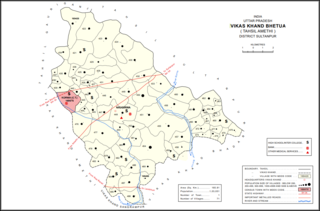
Piparpur is a village in Bhetua block of Amethi district, Uttar Pradesh, India. As of 2011, it has a population of 1,025 people, in 186 households. It has one primary school and no healthcare facilities and hosts a weekly haat but not a permanent market. It belongs to the nyaya panchayat of Amey Maphi.

References

  1. "Geonames Search". Do a radial search using these coordinates here.
  2. 1 2 3 4 5 "Census of India 2011: Uttar Pradesh District Census Handbook - Sultanpur, Part A (Village and Town Directory)" (PDF). Census 2011 India. pp. 539–56. Retrieved 13 November 2021.
  3. 1 2 3 4 5 6 7 8 Census 1991 Series-25 Uttar Pradesh Part-XII B Village & Townwise Primary Census Abstract District Census Handbook District Raebareli (PDF). 1992. pp. xxiv–xxviii, 324–5. Retrieved 28 November 2021.
  4. 1 2 3 Census 1981 Uttar Pradesh: District Census Handbook Part XIII-A: Village & Town Directory, District Rae Bareli (PDF). 1982. pp. 284–5. Retrieved 28 November 2021.
  5. 1 2 3 4 5 Census of India, 1951: District Census Handbook Uttar Pradesh (49 - Rae Bareli District) (PDF). Allahabad. 1955. pp. 106–7, 199. Retrieved 28 November 2021.{{cite book}}: CS1 maint: location missing publisher (link)
  6. 1 2 Census 1961: District Census Handbook, Uttar Pradesh (44 - Sultanpur District) (PDF). Lucknow. 1965. pp. cxxxxli–cxxxlii. Retrieved 28 November 2021.{{cite book}}: CS1 maint: location missing publisher (link)