
Kuala Lumpur Sentral Station is a transit-oriented development that houses the main railway station of Kuala Lumpur, the capital of Malaysia. Opened on 16 April 2001, KL Sentral replaced the old Kuala Lumpur railway station as the city's main inter-city railway station. KL Sentral is the largest railway station in Malaysia, and also in Southeast Asia from 2001 to 2021, before Krung Thep Aphiwat Central Terminal in Bangkok, Thailand was completed.

Bangsar is a residential suburb on the outskirts of Kuala Lumpur, lying about 4 kilometres (2.5 mi) south-west of the city centre. It is part of the Lembah Pantai parliamentary constituency. Bangsar is administered by Dewan Bandaraya Kuala Lumpur (DBKL), unlike other townships in the Klang Valley such as Petaling Jaya and Subang Jaya which have their municipal councils. Neighbourhood residents' associations and business councils play a part in communicating with the local authority, but they exercise no legal or administrative power. Malays make up most of the population at 61%, followed by the Chinese at 24%, Indians at 15%.
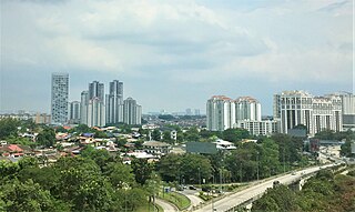
Petaling Jaya, colloquially referred to as "PJ", is a city in Petaling District, in the state of Selangor, Malaysia. Originally developed as a satellite township for Kuala Lumpur, the capital of Malaysia, it is part of the Greater Kuala Lumpur area. Petaling Jaya was granted city status on 20 June 2006. It has an area of approximately 97.2 square kilometres (37.5 sq mi).
Federal Highway is a Malaysian controlled-access highway connecting the capital city of Kuala Lumpur, and Klang, Selangor. The highway starts from Seputeh in Kuala Lumpur to Klang, Selangor. It is the busiest highway in Klang Valley during rush hour from/to Kuala Lumpur. The Federal Highway is coded as Federal Route 2.
The New Pantai Expressway (Malay: Lebuhraya Baru Pantai)New Pantai Expressway, is a controlled-access highway in the Klang Valley region of Peninsular Malaysia. The 19.6-kilometre (12.2-mile) expressway runs parallel to the Federal Highway, between Subang Jaya, Selangor in the southwest and Bangsar, Kuala Lumpur in the northeast.

Kuala Lumpur Middle Ring Road 2, Federal Route 28, is a ring road built by the Malaysian Public Works Department (JKR) to connect neighborhoods near the boundary of Federal Territory of Kuala Lumpur and Selangor. Altogether, the 65.0 km (40.4 mi) of the entire system consists of Federal Route 28, Damansara–Puchong Expressway Damansara–Puchong Expressway and Shah Alam Expressway Shah Alam Expressway. However, the Kuala Lumpur Middle Ring Road 2 is generally referred to as Route 28 since Route 28 occupies about two-thirds of the system.
The Federal Route 2 is a major east–west oriented federal highway in Malaysia. The 276.9 kilometres (172 mi) road connects Port Klang in Selangor to Kuantan Port in Pahang. The Federal Route 2 became the backbone of the road system linking the east and west coasts of Peninsula Malaysia before being surpassed by the East Coast Expressway E8.
Federal Route 5 is one of the three north–south oriented backbone federal roads running along the west coast of Peninsular Malaysia, Malaysia. The 655.85 kilometres (408 mi) federal highway runs from Jelapang, Perak in the north to Skudai, Johor in the south.

Brickfields is a neighbourhood located on the western flank of central Kuala Lumpur, Malaysia. It is known as Kuala Lumpur's Little India due to the high percentage of Indian residents and businesses. Brickfields has been ranked third in Airbnb's list of top trending destinations.

Sunway City is an 800-acre integrated township in Subang Jaya, Selangor, Malaysia. This township is named after its developer, Sunway Group, which had also got its name from Sungai Way, a suburb in Selangor. Sunway City is said to incorporate the urban planning concept of a 15-minute city.
Transport in Greater Kuala Lumpur includes a road network, a railway network, airports, and other modes of public transport. Greater Kuala Lumpur is conterminous with the Klang Valley, an urban conglomeration consisting of the city of Kuala Lumpur, as well as surrounding towns and cities in the state of Selangor. The Klang Valley has the country's largest airport, the Kuala Lumpur International Airport (KLIA), as well as the country's largest intermodal transport hub and railway station, Kuala Lumpur Sentral.

Tun Sambanthan station, is a Malaysian elevated monorail station that forms a part of the Kuala Lumpur Monorail line located in Kuala Lumpur and opened alongside the rest of the line and other adjoining monorail stations on 31 August 2003.

Jalan Klang Lama or Old Klang Road, Federal Route 2 is the oldest and the first major road in Kuala Lumpur, Malaysia. It was built before the Federal Highway was built in 1965. The road was constructed by the Federation of Malaya government from 1956 to 1959. The road was opened on 14 January 1959 by the Ministry of Public Works, Sardon Jubir. The road passing the two towns namely Sungei Way and Petaling Jaya.

Greater Kuala Lumpur is the geographical term that determines the boundaries of metropolitan Kuala Lumpur in Malaysia. Though similar to the term "Klang Valley", there remains a variation between the two. Ranked as the 30th-largest in Asia, it covers a total land size of 13,565.61km2.

The Malaysian Expressway System is a network of national controlled-access expressways in Malaysia that forms the primary backbone network of Malaysian national highways. The network begins with the Tanjung Malim–Slim River tolled road which was opened to traffic on 16 March 1966, later North–South Expressway (NSE), and is being substantially developed. Malaysian toll road-expressways are built by private companies under the supervision of the government highway authority, Malaysian Highway Authority. While toll-free expressways are built by Malaysian Public Works Department or Jabatan Kerja Raya Malaysia (JKR) in Malay.

The Sungai Besi Expressway, abbreviated as SBE, is a major controlled-access highway in the Klang Valley region of Peninsular Malaysia. The 28.3-kilometre (17.6-mile) expressway runs between Serdang and Ampang, Selangor through southeastern Kuala Lumpur, parallel and directly adjacent to the North–South Expressway and the Kuala Lumpur–Seremban Expressway.
The following is an alphabetical list of articles related to Selangor.
Old Town is the oldest urban area within the city of Petaling Jaya, a combined area of four inner suburbs within one of the biggest cities in Malaysia's most developed state of Selangor.

Setiawangsa–Pantai Expressway (SPE) is a 29.8-kilometre (18.5 mi) expressway in Klang Valley, Malaysia that connects Taman Melati and Klang Gates from FT 28 Kuala Lumpur Middle Ring Road 2 to Sprint Expressway - Kerinchi Link and FT 2 Federal Highway at Kerinchi near Pantai and University of Malaya. The alignment of this highway will traverse north to south of Kuala Lumpur and will serve areas such as Tunku Abdul Rahman University of Management and Technology, Wangsa Maju, Setiawangsa, Ampang, the Tun Razak Exchange and Bandar Malaysia development corridor as well as providing a connection to Kuala Lumpur-Karak Experessay to the east coast. It was built and maintained by Ekovest Berhad. It is formerly known as DUKE Phase 3.

