The Rah Ahan Stadium is a multi-purpose stadium in Tehran, Iran. It is currently used mostly for football matches and is the home stadium of Rah Ahan F.C., who currently play in Iran's Premier Football League. The stadium was owned by Persepolis F.C. prior to 1975. The stadium holds 12,000 people.
Yakubu Gowon Stadium is a multi-purpose stadium in the Elekahia suburb of Port Harcourt, Nigeria. It is currently used mostly for football matches and is the home stadium of Rivers United F.C. formerly Dolphins F.C. The stadium has a capacity of 16,000 people. In 2015, it was renamed in honor of former military head of state, General Yakubu Gowon.

Nové Hony is a village and municipality in Lučenec District in the Banská Bystrica Region of central Slovakia.

Krivaja is a village in Serbia. It is situated in the Bačka Topola municipality, in the North Bačka District, Vojvodina province. The village has a Serb ethnic majority and its population numbering 986 people.

Wolne is a village in the administrative district of Gmina Sztabin, within Augustów County, Podlaskie Voivodeship, in north-eastern Poland. It lies approximately 4 kilometres (2 mi) north-east of Sztabin, 21 km (13 mi) south-east of Augustów, and 66 km (41 mi) north of the regional capital Białystok.
Osiny-Zarębów is a village in the administrative district of Gmina Dmosin, within Brzeziny County, Łódź Voivodeship, in central Poland.

Milejów is a village in the administrative district of Gmina Rozprza, within Piotrków County, Łódź Voivodeship, in central Poland. It lies approximately 8 kilometres (5 mi) north-east of Rozprza, 7 km (4 mi) south of Piotrków Trybunalski, and 52 km (32 mi) south of the regional capital Łódź.

Wincentów is a settlement in the administrative district of Gmina Secemin, within Włoszczowa County, Świętokrzyskie Voivodeship, in south-central Poland. It lies approximately 7 kilometres (4 mi) north of Secemin, 10 km (6 mi) west of Włoszczowa, and 55 km (34 mi) west of the regional capital Kielce.

Janochy is a village in the administrative district of Gmina Troszyn, within Ostrołęka County, Masovian Voivodeship, in east-central Poland. It lies approximately 3 kilometres (2 mi) north-west of Troszyn, 10 km (6 mi) east of Ostrołęka, and 105 km (65 mi) north-east of Warsaw.
Jeziórko is a settlement in the administrative district of Gmina Czersk, within Chojnice County, Pomeranian Voivodeship, in northern Poland.

Rozpędziny is a village in the administrative district of Gmina Kwidzyn, within Kwidzyn County, Pomeranian Voivodeship, in northern Poland. It lies approximately 4 kilometres (2 mi) south-west of Kwidzyn and 76 km (47 mi) south of the regional capital Gdańsk.

Jastrzębie is a village in the administrative district of Gmina Osieczna, within Starogard County, Pomeranian Voivodeship, in northern Poland. It lies approximately 8 kilometres (5 mi) north-west of Osieczna, 31 km (19 mi) south-west of Starogard Gdański, and 69 km (43 mi) south-west of the regional capital Gdańsk.

Łuby is a village in the administrative district of Gmina Osiek, within Starogard County, Pomeranian Voivodeship, in northern Poland. It lies approximately 8 kilometres (5 mi) west of Osiek, 31 km (19 mi) south of Starogard Gdański, and 75 km (47 mi) south of the regional capital Gdańsk.

Janiszewko is a village in the administrative district of Gmina Pelplin, within Tczew County, Pomeranian Voivodeship, in northern Poland. It lies approximately 3 kilometres (2 mi) south of Pelplin, 22 km (14 mi) south of Tczew, and 52 km (32 mi) south of the regional capital Gdańsk.

Stocki Młyn is a settlement in the administrative district of Gmina Pelplin, within Tczew County, Pomeranian Voivodeship, in northern Poland. It lies approximately 5 kilometres (3 mi) south of Pelplin, 25 km (16 mi) south of Tczew, and 54 km (34 mi) south of the regional capital Gdańsk.
Janiki Małe is a village in the administrative district of Gmina Zalewo, within Iława County, Warmian-Masurian Voivodeship, in northern Poland.

Kołpaki is a settlement in the administrative district of Gmina Purda, within Olsztyn County, Warmian-Masurian Voivodeship, in northern Poland. It lies approximately 9 kilometres (6 mi) west of Purda and 10 km (6 mi) south-east of the regional capital Olsztyn.

Donje Luge is a small town in Berane Municipality, Montenegro. According to the 2003 census, the town has a population of 1861 people.

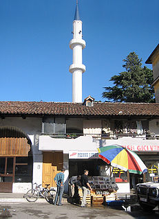
The Mosque of Mahmud Agha Kokonozi or New Bazaar Mosque is an Ottoman-era mosque built in 1750 and one of the few mosques that survived the communist dictatorship under the Hoxhaist regime.


