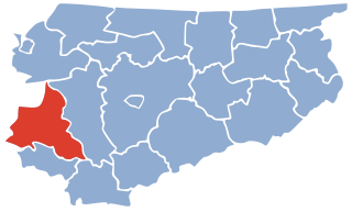
Gromoty is a village in the administrative district of Gmina Iława, within Iława County, Warmian-Masurian Voivodeship, in northern Poland. It lies approximately 11 kilometres (7 mi) east of Iława and 55 km (34 mi) west of the regional capital Olsztyn.
Kozianka is a settlement in the administrative district of Gmina Iława, within Iława County, Warmian-Masurian Voivodeship, in northern Poland.
Nejdyki is a village in the administrative district of Gmina Iława, within Iława County, Warmian-Masurian Voivodeship, in northern Poland. It lies approximately 5 kilometres (3 mi) north-west of Iława and 69 km (43 mi) west of the regional capital Olsztyn.
Papiernia is a settlement in the administrative district of Gmina Iława, within Iława County, Warmian-Masurian Voivodeship, in northern Poland.
Rudzienice is a village in the administrative district of Gmina Iława, within Iława County, Warmian-Masurian Voivodeship, in northern Poland. It lies approximately 8 kilometres (5 mi) north-east of Iława and 58 km (36 mi) west of the regional capital Olsztyn.
Szeplerzyzna is a village in the administrative district of Gmina Iława, within Iława County, Warmian-Masurian Voivodeship, in northern Poland. It lies approximately 3 kilometres (2 mi) south-west of Iława and 68 km (42 mi) west of the regional capital Olsztyn.
Szwalewo is a settlement in the administrative district of Gmina Iława, within Iława County, Warmian-Masurian Voivodeship, in northern Poland.
Trupel is a village in the administrative district of Gmina Kisielice, within Iława County, Warmian-Masurian Voivodeship, in northern Poland. It lies approximately 8 kilometres (5 mi) east of Kisielice, 14 km (9 mi) west of Iława, and 78 km (48 mi) west of the regional capital Olsztyn.
Napromek is a village in the administrative district of Gmina Lubawa, within Iława County, Warmian-Masurian Voivodeship, in northern Poland. It lies approximately 22 km (14 mi) south-east of Iława and 54 km (34 mi) south-west of the regional capital Olsztyn.
Brusiny is a village in the administrative district of Gmina Susz, within Iława County, Warmian-Masurian Voivodeship, in northern Poland. It lies approximately 6 kilometres (4 mi) south-east of Susz, 16 km (10 mi) north-west of Iława, and 72 km (45 mi) west of the regional capital Olsztyn.
Lubnowy Wielkie is a village in the administrative district of Gmina Susz, within Iława County, Warmian-Masurian Voivodeship, in northern Poland. It lies approximately 8 kilometres (5 mi) north of Susz, 26 km (16 mi) north-west of Iława, and 77 km (48 mi) west of the regional capital Olsztyn.
Bajdy is a village in the administrative district of Gmina Zalewo, within Iława County, Warmian-Masurian Voivodeship, in northern Poland. It lies approximately 5 kilometres (3 mi) north-west of Zalewo, 31 km (19 mi) north of Iława, and 64 km (40 mi) west of the regional capital Olsztyn.
Brzeziniak is a settlement in the administrative district of Gmina Zalewo, within Iława County, Warmian-Masurian Voivodeship, in northern Poland. It lies approximately 3 kilometres (2 mi) north-west of Zalewo, 30 km (19 mi) north of Iława, and 61 km (38 mi) west of the regional capital Olsztyn.
Duba is a village in the administrative district of Gmina Zalewo, within Iława County, Warmian-Masurian Voivodeship, in northern Poland.
Karpowo is a village in the administrative district of Gmina Zalewo, within Iława County, Warmian-Masurian Voivodeship, in northern Poland. It lies approximately 11 kilometres (7 mi) south of Zalewo, 18 km (11 mi) north of Iława, and 58 km (36 mi) west of the regional capital Olsztyn.
Polajny is a village in the administrative district of Gmina Zalewo, within Iława County, Warmian-Masurian Voivodeship, in northern Poland. It lies approximately 6 kilometres (4 mi) south of Zalewo, 23 km (14 mi) north of Iława, and 60 km (37 mi) west of the regional capital Olsztyn.
Pomielin is a village in the administrative district of Gmina Zalewo, within Iława County, Warmian-Masurian Voivodeship, in northern Poland. It lies approximately 9 kilometres (6 mi) south of Zalewo, 20 km (12 mi) north of Iława, and 59 km (37 mi) west of the regional capital Olsztyn.
Rudnia is a village in the administrative district of Gmina Zalewo, within Iława County, Warmian-Masurian Voivodeship, in northern Poland. It lies approximately 6 kilometres (4 mi) south of Zalewo, 23 km (14 mi) north of Iława, and 58 km (36 mi) west of the regional capital Olsztyn.
Urowo is a village in the administrative district of Gmina Zalewo, within Iława County, Warmian-Masurian Voivodeship, in northern Poland. It lies approximately 14 kilometres (9 mi) south-east of Zalewo, 18 km (11 mi) north-east of Iława, and 54 km (34 mi) west of the regional capital Olsztyn.
Witoszewo is a village in the administrative district of Gmina Zalewo, within Iława County, Warmian-Masurian Voivodeship, in northern Poland. It lies approximately 7 kilometres (4 mi) west of Zalewo, 27 km (17 mi) north of Iława, and 66 km (41 mi) west of the regional capital Olsztyn.