
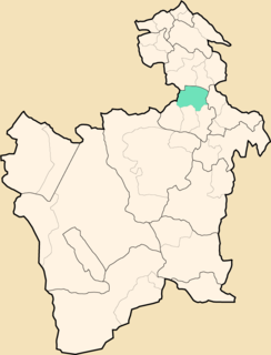
José María Linares is a province in the eastern parts of the Bolivian department of Potosí. Its capital is Puna.
The Tumusla River is a river of Bolivia in the Potosí Department as well as in the Chuquisaca Department. It gets waters from the Los Frailes and Chichas mountain ranges. Upstream the river is named Yura and Toropalca. Cotagaita, a right affluent, is its most important tributary.

Potosí Municipality is the capital municipality of the Tomás Frías Province in the Potosí Department in Bolivia. Its seat is Potosí which is the capital of the department as well.
Tinguipaya Municipality is the first municipal section of the Tomás Frías Province in the Potosí Department in Bolivia. Its seat is Tinguipaya.

Yocalla Municipality is the second municipal section of the Tomás Frías Province in the Potosí Department in Bolivia. Its seat is Yocalla.
Jatun Mayu is a Bolivian river in the Cochabamba Department, Tiraque Province, Tiraque Municipality and south of it in the Arani Province, Vacas Municipality. It is one of the most important tributaries of Parqu Qucha, a lake north west of Vacas. It originates north east of Punata. It changes its directions from north west to north, then near Palca it abruptly turns to the south east.
Jatun Mayu or Hatun Mayu may refer to:
Kachi Mayu is a Bolivian river east of Poopó Lake in the Oruro Department, Challapata Province, Challapata Municipality. Its source, the Jach'a Juqhu River, is considered the origin of the Pillku Mayu.

Jatun Mayu is a Bolivian river in the Cochabamba Department, Esteban Arce Province, in the Anzaldo and Sacabamba Municipalities. Its waters flow to Laguna Angostura.
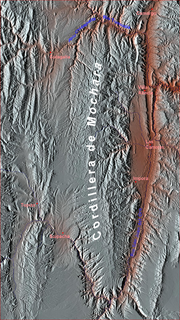
Tarapaya River, originally also called Qayara, is a Bolivian river in the Potosí Department, Tomás Frías Province. Its direction is mainly north. Tarapaya is a right tributary of the upper Pillku Mayu.
Jayaq Mayu is a Bolivian river in the Potosí Department, Tomás Frías Province, in the south of Potosí. It originates on the west side of the mountain Cerro Rico or P'utuqsi Urqu located in the Potosí Municipality. Then it flows in a north west direction until meeting Agua Dulce River in the Yocalla Municipality. This river shortly afterwards forms the Tarapaya River at its confluence with Ribera de la Vera Cruz. Jayaq Mayu belongs to the Pillku Mayu drainage basin.
Jatun Mayu which downstream successively is named Challajtiri Mayu, Rosario, Agua Castilla, Jatun Mayu again and Qaysa is a Bolivian river in the provinces of Antonio Quijarro, José María Linares and Tomás Frías of the Potosí Department. It belongs to the Pillku Mayu river basin.

Yana Mayu is a 4,797-metre-high (15,738 ft) mountain in the Potosí mountain range of the Bolivian Andes. It is located in the Potosí Department, on the border of the Cornelio Saavedra Province, Chaqui Municipality, and the José María Linares Province, Puna Municipality. It is situated northeast of Jatun Kunturiri. The lakes named Kimsa Qucha and Q'ara Qucha lie at its feet.
Wayra Wasi is a 4,416-metre-high (14,488 ft) mountain in the Bolivian Andes. It is situated in the Potosí Department, Tomás Frías Province, Potosí Municipality. Wayra Wasi lies west of Jatun Q'asa and the Ch'aki Mayu. The river originates southeast of the mountain. It flows to the north.
Jatun Q'asa is a 4,590-metre-high (15,059 ft) mountain in the Bolivian Andes. It is situated in the Potosí Department, Tomás Frías Province, Potosí Municipality. Some of the nearest settlements are Umallani and Salla K'uchu. Jatun Q'asa lies east Wayra Wasi, between the Ch'aki Mayu in the west and the Challwiri River (Challviri) in the east. Both rivers flow to the north as right tributaries of the Pillku Mayu.
Jatun Urqu is a 2,629-metre-high (8,625 ft) mountain in the Bolivian Andes. It is located in the Potosí Department, Chayanta Province, Ravelo Municipality. It lies east of the Quri Mayu.
Jatun Mayu is a Bolivian river in the Chuquisaca Department, Jaime Zudáñez Province, Icla Municipality. It is a left affluent of the Icla River. It belongs to the watershed of the Pillku Mayu.
Lluqu Lluqu is a 4,234-metre-high (13,891 ft) mountain in the Bolivian Andes. It is located in the Potosí Department, Antonio Quijarro Province, Porco Municipality. Lluqu Lluqu lies between the Topala River and the Jatun Mayu northwest of Urqu Maki.
Jatun Ch'utu is a mountain in the Bolivian Andes which reaches a height of approximately 4,220 m (13,850 ft). It is located in the Potosí Department, Tomás Frías Province, Potosí Municipality. It lies southeast of the village of Juch'uy Wasi (Juchuy Huasi). The Jatun Mayu flows along its southern slopes.


