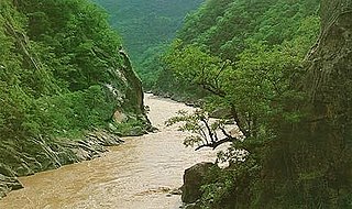
Pilcomayo is a river in central South America. At 1,100 kilometres (680 mi) long, it is the longest western tributary of the Paraguay River. Its drainage basin is 270,000 square kilometres (100,000 sq mi) in area, and its mean discharge is 200 cubic metres per second (7,100 cu ft/s).

José María Linares is a province in the eastern parts of the Bolivian department of Potosí. Its capital is Puna.
Luru Mayu Lake is a lake in Bolivia located in the Potosí Department, Sud Lípez Province, San Pablo de Lípez Municipality. At an elevation of 4,666 m, its surface area is 12 km². It lies in the Eduardo Avaroa Andean Fauna National Reserve, northwest of a mountain called Luru Mayu. The lake is named after a river which originates in the mountains south and southeast of the lake.
The Tumusla River is a river of Bolivia in the Potosí Department as well as in the Chuquisaca Department. It gets waters from the Los Frailes and Chichas mountain ranges. Upstream the river is named Yura and Toropalca. Cotagaita, a right affluent, is its most important tributary.
The Yura River is a river of Bolivia in the Potosí Department, Antonio Quijarro Province. Its waters flow to the Pillku Mayu while the river successively receives the names Toropalca, Tumusla, Camblaya and Pilaya. Pilaya River is a right tributary of Pillku Mayu.
Tarapaya is one of the cantons of the Potosí Municipality, the capital municipality of the Tomás Frías Province in the Potosí Department of Bolivia. During the census of 2001 it had 1,042 inhabitants. Its seat is Tarapaya with a population of 11 in 2001. It is situated east of Tarapaya River.

Potosí Municipality is the capital municipality of the Tomás Frías Province in the Potosí Department in Bolivia. Its seat is Potosí which is the capital of the department as well.
Jatun Mayu which upstream is called Tinkipaya is a Bolivian river in the Potosí Department, Tomás Frías Province, Tinkipaya Municipality, Tinkipaya Canton, north of Potosí. It is a left tributary of the upper Pillku Mayu. The confluence is about 10 km south east of Tinkipaya.
Puka Mayu is a Bolivian river in the Potosí Department, Nor Lípez Province, Colcha "K" Municipality. It originates in the Cordillera de Lípez and empties into the Uyuni salt flat. The mouth lies west and south west of the town Uyuni and north east of the mouth of the Río Grande de Lípez.
Kachi Mayu is a Bolivian river east of Poopó Lake in the Oruro Department, Challapata Province, Challapata Municipality. Its source, the Jach'a Juqhu River, is considered the origin of the Pillku Mayu.
Ch'aki Mayu, also Kachi Mayu, is a Bolivian river in the Potosí Department. It flows towards the Pillku Mayu.
Jayaq Mayu is a Bolivian river in the Potosí Department, Tomás Frías Province, in the south of Potosí. It originates on the west side of the mountain Cerro Rico or P'utuqsi Urqu located in the Potosí Municipality. Then it flows in a north west direction until meeting Agua Dulce River in the Yocalla Municipality. This river shortly afterwards forms the Tarapaya River at its confluence with Ribera de la Vera Cruz. Jayaq Mayu belongs to the Pillku Mayu drainage basin.
Jatun Mayu which downstream successively is named Challajtiri Mayu, Rosario, Agua Castilla, Jatun Mayu again and Qaysa is a Bolivian river in the provinces of Antonio Quijarro, José María Linares and Tomás Frías of the Potosí Department. It belongs to the Pillku Mayu river basin.
T'uruchipa is a Bolivian river in the Potosí Department, José María Linares Province, Ckochas Municipality, T'uruchipa Canton. It is a right tributary to the Pillku Mayu.

Tatasi River is a Bolivian river in the Potosí Department, Sud Chichas Province, Atocha Municipality and Tupiza Municipality. It is a left tributary of Tupiza River and belongs to the river basin of the upper Pillku Mayu.

Lik'ichiri is a mountain in the Andes of Bolivia in the Potosí Department, Tomás Frías Province, Potosí Municipality. It lies north of Potosí and the river Samasa and east of the village Tarapaya. Lik'ichiri is about 4,086 metres (13,406 ft) high.
Waylla Tira is a 4,324-metre-high (14,186 ft) mountain in the Andes of Bolivia. It is located in the Potosí Department, Tomás Frías Province, Potosí Municipality. Waylla Tira lies east of the Challwiri River, an affluent of the Pillku Mayu.
Luru Mayu is a 5,888-metre-high (19,318 ft) mountain in Bolivia. It is located in the Potosí Department, Sud Lípez Province, San Pablo de Lípez Municipality. It lies in the Eduardo Avaroa Andean Fauna National Reserve, southeast of a lake named Luru Mayu.
Wañuma is a 4,202-metre-high (13,786 ft) mountain in the Andes of Bolivia. It is located in the Potosí Department, Cornelio Saavedra Province, Tacobamba Municipality. Wañuma lies on the right bank of the Ch'aki Mayu. Its waters flow to the Pillku Mayu :


